List of Irish counties by highest point

This is a list of Irish counties by their highest point. These are most commonly known as county high points but are also sometimes referred to as county tops and county peaks. There are 32 counties in Ireland but in the case of 10 counties, marked with (‡), the highest point is shared between two counties, so there are only 27 distinct Irish county high points. This list is generated from the Irish MountainViews Online Database (October 2018 edition). The overall ranking of an Irish County High Point against all other peaks in Ireland is based on the Vandeleur-Lynam definition where a peak must have a minimum topographic prominence of 15 metres (49 ft) to be on the list of peaks in Ireland. The four Irish provincial tops, also referred to as province high points, are also listed. The listings of Irish county high points under the definitions of Irish mountains (e.g. Furths, Marilyn, Arderins), are also provided.
The list of Irish county and provincial high points contains four of Ireland's five Real Munros, and 14 of Ireland's 25 P600 "Major" mountains.
Ireland's County High Points is one of 16 sub-lists, which together comprise the complete list of 188 major Irish geographical high points.
List
- # = Rank Table
- H = Height
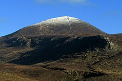
Gallery


 Mullaghmeen Hill in County Westmeath, the lowest of all County Tops in Ireland.
 Carn Clonhugh (or Corn Hill) in County Longford, is the most isolated County Top in Ireland.


