Pitt Street
Pitt Street is a major street in the Sydney central business district in New South Wales, Australia. The street runs through the entire city centre from Circular Quay in the north to Waterloo, although today's street is in two disjointed sections after a substantial stretch of it was removed to make way for Sydney's Central railway station. Pitt Street is well known for the pedestrian only retail centre of Pitt Street Mall, a section of the street which runs from King Street to Market Street.
Pitt Street is a one way (southbound only) from Circular Quay to Pitt Street Mall and (northbound only) from Pitt Street Mall to Goulburn Street, while Pitt Street Mall is for pedestrians only. It is dominated by retail and commercial office space.
History
Pitt Street was originally named Pitt Row, and is one of the earliest named streets in Sydney. Pitt Street is believed to have been named by Governor Arthur Phillip in honour of William Pitt the Younger, at the time, the Prime Minister of Great Britain. In 1853, Pitt Street was extended north from Hunter Street to Circular Quay.

Pitt Street was previously a one-way street in a southerly direction from Circular Quay to Campbell Street. In preparation for the construction of the Pitt Street Mall, in February 1987 the sections between Hunter Street and Martin Place, and Martin Place and King Street were converted to two-way cul de sacs to allow the Martin Place plaza to be extended. This was later reverted and today the Circular Quay to King Street section is one-way throughout in a southerly direction. From Goulburn Street to Park Street was converted to become one-way in a northerly direction. The Market Street to Park Street section initially remained as a southbound street, but was later converted to run northbound. The Goulburn Street to Campbell Street section was converted to two-way.
Tram line
The Circular Quay to Central station line was an important part of the Sydney tram network. It was an extremely busy service for passengers transferring from suburban trains, particularly prior to the opening of the City Circle underground railway line in 1926. Trams operated in a loop from Central station, running north along Pitt Street to Circular Quay returning south via Castlereagh Street. These tracks were also used by some eastern and south-western routes during busy periods. The line closed on 27 September 1957 with four tram services replaced with buses and three others diverted to operate via Elizabeth Street. The line made use of the sandstone viaduct onto the colonnade above Eddy Avenue at Central station, which since 1997 has formed part of the Inner West Light Rail.
Heritage-listed properties
The following properties, located on or adjacent to Pitt Street, are listed on various national, state, and/or local government heritage registers:
- Bulletin Place warehouses, on Bulletin Place, between Pitt Street and Macquarie Place
- Commonwealth Trading Bank Building
- Kings Hotel
- Pitt Street Uniting Church
- Soul Pattinson Building
- The Strand Arcade
- Sydney School of Arts building
- Former Sydney Water Head Office
- The Sydney Club
- Wales House, now part of the Radisson Blu hotel chain
Pitt Street Cycleway
During the COVID-19 epidemic in 2020 the City of Sydney installed a "pop up" (or temporary) cycleway on Pitt Street. This cycleway was the busiest of all the pop up cycleways installed, with an average of 4430 weekly trips.
In March 2021 the city announced the cycleway would become permanent. It now connects to the King Street cycleway at the south end.
Gallery
![Sydney's first Tramways depot, corner of Pitt Street and what was then Gipps St West and Garden Road, looking SE across the Old Cemeteries towards Surry Hills. Eddy Avenue roughly follows Garden Road,[25] c. 1880.](https://upload.wikimedia.org/wikipedia/commons/thumb/9/9b/The_first_Tramways_Dated_c._10_1_1880_Depot_at_Pitt_Street.jpg/120px-The_first_Tramways_Dated_c._10_1_1880_Depot_at_Pitt_Street.jpg) Sydney's first Tramways depot, corner of Pitt Street and what was then Gipps St West and Garden Road, looking SE across the Old Cemeteries towards Surry Hills. Eddy Avenue roughly follows Garden Road, c. 1880.
Sydney's first Tramways depot, corner of Pitt Street and what was then Gipps St West and Garden Road, looking SE across the Old Cemeteries towards Surry Hills. Eddy Avenue roughly follows Garden Road, c. 1880.

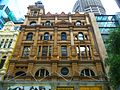 Building in Italianate style
 Restored 1903 building
 Pitt Street Mall from King Street looking south
 Looking south c. 1900
 Archival image of Pitt and Hunter Streets, showing Wales House
 Pitt Street Uniting Church interior
 Building labourer on a stone being hoisted up to building, Pitt St, Sydney, c. 1930s. Photo by Sam Hood.
 Pitt Street Uniting Church
![Sydney's first Tramways depot, corner of Pitt Street and what was then Gipps St West and Garden Road, looking SE across the Old Cemeteries towards Surry Hills. Eddy Avenue roughly follows Garden Road,[25] c. 1880.](https://en.wikipedia.org/wiki/File:The_first_Tramways_Dated_c._10_1_1880_Depot_at_Pitt_Street.jpg)
_City_Tattersals_Club.JPG)

_Pitt_Street_(a).JPG)
_Pitt_Street_(d).JPG)


Pitt_St_Uniting_Church-5.jpg)
.jpg)
Pitt_St_Uniting_Church-4.jpg)
References
External links
- Catherine Bishop (2011). "Women of Pitt Street 1858". Dictionary of Sydney. Retrieved 30 September 2015. [CC-By-SA]
- Shirley Fitzgerald – City of Sydney History Unit (2008). "Poverty Point [corner of Park and Pitt Streets]". Dictionary of Sydney. Retrieved 28 September 2015. [CC-By-SA]