Wikipedia:WikiProject Maps/Conventions/Locator maps

This page provides conventions for the creation of locator maps.
Usage: Locator maps are first create blank maps aiming to be derivated into several specific Locator maps, Areas maps, Historical maps, Exchange maps.
Creation: Locator maps are conveniently derivate from country or wider area Location maps (blank). The map maker has to color the ocean, land, rivers, subject area, to the Locator maps conventional colours. Locator maps are very basic, and should not have, or have very few labels. Their aim is to show the geographical occupation in a wider context, not to explain this occupation.
Convention
Inset maps
Inset maps may be used with in locator maps so that the location can be seen in a wider context; the subject being located within larger-scale map (the local map), accompanied by a smaller scale map of the country or wider region (the wide map). Two versions are commonly seen:
- The wide map in an inset within the local map;
- The local map as an inset within the wide map.
As an example of each:
 |  |
Gallery of examples
| This Wikipedia page may require cleanup to meet Wikipedia's quality standards. No cleanup reason has been specified. Please help improve this Wikipedia page if you can; the talk page may contain suggestions. |
 Note: This widely used scheme should now become the semi-official locator style.
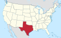 State within its larger union (USA)
 Zoomed in territory with circle markers
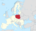 Country within its larger union (European Union)
 Country w/o context
-en.svg)
.svg)
_(zoom).svg)
.svg)
.svg)
Ancient scheme
Extended content |
|---|
This 2008 scheme has been supersed by the 2012 scheme. |
See also
- Commons:Category:SVG locator maps (location map scheme)
- Wikipedia:WikiProject Maps/Conventions/Locator maps (2008) - supersed
- Hack, Hans; Aisch, Gregor (Oct 10, 2018), Introducing Locator Maps in Datawrapper, Datawrapper
- Hack, Hans; Aisch, Gregor (Oct 10, 2018), Locator Maps App, Datawrapper