List of earthquakes in 2026

Earthquakes in 2026
List of earthquakes in 2026 is located in Earth
List of earthquakes in 2026
Approximate epicenters of notable earthquakes in 2026
StrongestMw 7.8  Philippines
Mw 7.8  Indonesia
DeadliestMw 7.5  Venezuela
6,509 deaths
Total fatalities7,199
Number by magnitude
9.0+0
8.0–8.90
7.0–7.913
6.0–6.9108
5.0–5.91,475
4.0–4.911,004
← 2025

This is a list of earthquakes in 2026. Only earthquakes of magnitude 6 or above are included, unless they result in significant damage and/or casualties. All dates are listed according to UTC time. The maximum intensities are based on the Modified Mercalli intensity scale. Earthquake magnitudes are based on data from the United States Geological Survey (USGS).

Compared to other years

Number of earthquakes worldwide for 2016–2026
[Edit]
Magnitude1999200020012002200320042005200620072008200920102011201220132014201520162017201820192020202120222023202420252026
8.0–9.9 0 1 1 0 1 2 1 2 4 1 1 1 1 2 2 1 1 0 1 1 1 0 3 0 0 0 1 0
7.0–7.9 18 15 14 13 14 14 10 9 14 12 16 23 19 15 17 11 18 16 6 16 9 9 16 11 19 10 15 13
6.0–6.9 117 145 122 126 139 141 139 142 178 167 143 150 187 117 123 143 127 131 104 117 135 112 138 116 128 89 129 106
5.0–5.9 1,057 1,334 1,212 1,170 1,212 1,511 1,694 1,726 2,090 1,786 1,912 2,222 2,494 1,565 1,469 1,594 1,425 1,561 1,456 1,688 1,500 1,329 2,070 1,599 1,633 1,408 1,984 1,475
4.0–4.9 7,004 7,968 7,969 8,479 8,455 10,880 13,893 12,843 12,081 12,294 6,817 10,135 13,130 10,955 11,877 15,817 13,776 13,700 11,541 12,785 11,899 12,513 15,069 14,022 14,450 12,668 16,023 11,004
Total 8,296 9,462 9,319 9,788 9,823 12,551 15,738 14,723 14,367 14,261 8,891 12,536 15,831 12,660 13,491 17,573 15,351 15,411 13,113 14,614 13,555 13,967 17,297 15,749 16,231 14,176 18,152 12,598
Map of earthquakes in 2026 - M 5.0 or greater (map data)

By death toll

Rank Death toll Mag. Location MMI Depth (km) Date Event
1 6,509 7.5  Venezuela, La Guaira offshore IX (Violent) 10.0 June 24 2026 Venezuela earthquakes
7.2 IX (Violent) 10.0
2 335 7.4  Colombia, Chocó VIII (Severe) 110.3 August 10 2026 Colombia earthquake
3 142 7.8  Indonesia, East Nusa Tenggara offshore VIII (Severe) 10.0 August 14 2026 Flores earthquake
4 107 7.8  Philippines, Soccsksargen offshore IX (Violent) 57.0 June 7 2026 Mindanao earthquake
5 38 6.8  Japan, Kumamoto IX (Violent) 8.0 July 28 2026 Kumamoto earthquake
7 16 7.0  China, Tibet Autonomous Region VIII (Severe) 18.0 October 22 2026 Tibet earthquake
8 12 5.8  Afghanistan, Badakhshan III (Weak) 186.4 April 3 2026 Jurm earthquake

Listed are earthquakes with at least 10 reported fatalities.

By magnitude

Rank Mag. Death toll Location MMI Depth (km) Date Event
1 7.8 107  Philippines, Soccsksargen offshore IX (Violent) 57.0 June 7 2026 Mindanao earthquake
7.8 142  Indonesia, East Nusa Tenggara offshore VIII (Severe) 10.0 August 14 2026 Flores earthquake
3 7.7 2  Panama, Herrera IX (Violent) 12.6 October 9 2026 Panama earthquake
4 7.5 6,509  Venezuela, La Guaira offshore IX (Violent) 10.0 June 24 2026 Venezuela earthquakes
7.5 –  Tonga, Vava'u offshore V (Moderate) 229.5 March 24 –
6 7.4 335  Colombia, Chocó VIII (Severe) 110.3 August 10 2026 Colombia earthquake
7.4 1  Indonesia, North Maluku offshore VIII (Severe) 35.0 April 1 2026 North Maluku earthquake
7.4 –  Japan, Iwate offshore VI (Strong) 25.0 April 20 2026 Sanriku earthquake
9 7.3 –  Mexico, Chiapas offshore VII (Very strong) 15.3 July 17 –
7.3 –  Vanuatu, Sanma offshore VII (Very strong) 121.3 March 30 –
11 7.2 –  Venezuela, Yaracuy IX (Violent) 10.0 June 24 2026 Venezuela earthquakes
12 7.1 –  Malaysia, Sabah offshore V (Moderate) 629.0 February 22 –
13 7.0 16  China, Tibet Autonomous Region VIII (Severe) 18.0 October 22 2026 Tibet earthquake

Listed are earthquakes with at least 7.0 magnitude.

  1. 1 2 A combined death toll is given for the 2026 Venezuela earthquakes.

By month

January

January
StrongestMw 6.5  Mexico
DeadliestMw 6.5  Mexico
2 deaths
Mw 5.6  Pakistan
2 deaths
Total fatalities4
Number by magnitude
9.0+0
8.0–8.90
7.0–7.90
6.0–6.910
5.0–5.9169
4.0–4.91,067
Date Country and location M Depth (km) MMI Notes Casualties
Dead Injured
1 Southeast Indian Ridge 6.0 10.0 - - - -
2  Mexico, Guerrero, 4 km (2.5 mi) NNW of Rancho Viejo 6.5 18.0 VII 2 24
4  India, Assam, 13 km (8.1 mi) SW of Dhing 5.2 35.0 V Three people injured in Morigaon and several homes damaged in the Morigaon-Nagaon area. - 3
6  Japan, Shimane, 18 km (11 mi) S of Matsue 5.7 10.0 VII Fifteen people injured and 114 homes damaged in Hyōgo, Tottori, Shimane, Okayama and Hiroshima prefectures. Ceiling panels in Yonago City Hall fell, fences and walls collapsed in Hōki, the wall of a building collapsed in Matsue, one house damaged in Tamano and a fire station cracked in Okayama. - 15
7  Philippines, Davao offshore, 16 km (9.9 mi) E of Baculin 6.4 22.0 VI Aftershock of the 2025 Davao Oriental earthquakes. A chapel partially collapsed in Caraga. - -
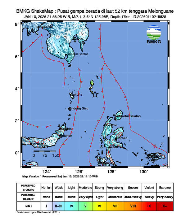
10  Indonesia, North Sulawesi offshore, 245 km (152 mi) NNW of Tobelo 6.4 31.0 VII At least 14 structures damaged in Talaud Islands Regency. - -
13  Russia, Sakhalin offshore, 133 km (83 mi) SE of Kurilsk 6.2 35.8 V - - -
16  United States, Oregon offshore, 295 km (183 mi) W of Bandon 6.0 10.0 IV - - -
17  Honduras, Cortés offshore, 12 km (7.5 mi) N of Cuyamel 5.2 6.9 V At least 50 homes damaged in the Omoa area. - -
17  Mexico, Guerrero, 7 km (4.3 mi) ESE of Barrio Nuevo de los Muertos 4.9 10.0 V Aftershock of the 2026 Guerrero earthquake. Additional damage to homes in the San Marcos area. - -
19  Pakistan, Gilgit-Baltistan, 47 km (29 mi) NNW of Barishal 5.6 23.0 VI Two people killed, five others injured, 300 homes destroyed, 300 others and many buildings damaged in the Chipursan area. 2 5
19  China, Yunnan, 38 km (24 mi) SW of Zhaotong 5.2 10.0 IV About 1,540 homes damaged and landslides and rockfalls occurred in Qiaojia County. - -
19  New Caledonia, Loyalty Islands offshore, 260 km (160 mi) ESE of Tadine 6.0 10.0 - - - -
21  Poland, Lower Silesian Voivodeship, 4 km (2.5 mi) WNW of Lubin 3.5 1.0 - Two people injured at the Lubin mine. - 2
21  Japan, Volcano Islands offshore 6.1 25.5 III - - -
22  Russia, Kamchatka offshore, 128 km (80 mi) S of Vilyuchinsk 6.2 52.2 V Aftershock of the 2025 Kamchatka earthquake. - -
23  Indonesia, West Kalimantan, 156 km (97 mi) SSE of Simanggang, Malaysia 4.8 10.0 IV Some walls collapsed, several homes and a bridge damaged in Sintang Regency. - -
23  Turkey, Balıkesir, 11 km (6.8 mi) ESE of Sındırgı 4.9 11.0 - Aftershock of the 2025 Balıkesir earthquakes. One home damaged in Sındırgı. - -
24  Madagascar, Itasy, 11 km (6.8 mi) SW of Soavinandriana 4.9 10.0 IV One person injured and two structures collapsed in the epicentral area. - 1
26  China, Gansu, 9 km (5.6 mi) ESE of Dianga 5.5 10.0 VII One home collapsed, several others damaged and landslides occurred in Têwo County. - -
27  Indonesia, East Java, 19 km (12 mi) SSW of Ponorogo 5.7 127.0 IV Three people injured and one office building damaged in Trenggalek Regency. Six homes damaged in Malang, Pacitan, and Ponorogo regencies. One school damaged in Tulungagung Regency. - 3
27  Indonesia, Yogyakarta, 5 km (3.1 mi) SE of Pundong 4.6 10.0 III Two people injured, 18 homes and one school damaged in Klaten Regency. At least 12 buildings damaged in Gunung Kidul and Bantul regencies. - 2
29 South Sandwich Islands region 6.0 68.1 IV - - -

February

February
StrongestMw 7.1  Malaysia
DeadliestMw 5.8  Indonesia
1 death
Total fatalities1
Number by magnitude
9.0+0
8.0–8.90
7.0–7.91
6.0–6.97
5.0–5.9105
4.0–4.9966
Date Country and location M Depth (km) MMI Notes Casualties
Dead Injured
1 Iran, Bushehr offshore, 27 km (17 mi) WSW of Mohr 5.2 10.0 V Some walls collapsed, windows shattered and damage to several transformers and electricity poles in Asaluyeh. - -
1  Indonesia, Bali, 8 km (5.0 mi) E of Amlapura 3.5 12.0 - At least two homes seriously damaged in Karangasem Regency. - -
2 India, Jammu and Kashmir, 16 km (9.9 mi) WNW of Tsrār Sharīf 4.8 10.0 III Many homes damaged in the Uri area. - -
4  New Zealand, Kermadec Islands offshore 6.1 184.2 IV - - -
5  Indonesia, East Java offshore, 94 km (58 mi) SW of Trenggalek 5.8 40.0 IV One person killed in Pacitan, five homes destroyed and 57 structures damaged in East Java. Forty-seven people injured and 22 buildings damaged in Yogyakarta. One home destroyed in Kebumen Regency and five structures damaged in Central Java. 1 47
6  Turkey, Erzincan, 19 km (12 mi) S of Refahiye 4.7 10.0 - Landslides and rockfalls occurred in the epicentral area and Kemah District. - -
8  Chile, Tarapacá, 76 km (47 mi) ENE of La Tirana 5.7 119.0 V One church severely damaged in Huara. - -
10  Fiji region offshore 6.2 510.9 III - - -
12  Chile, Coquimbo, 32 km (20 mi) SW of Ovalle 6.2 36.9 VI One house damaged in Punitaqui. Rockfalls occurred in the Agua Negra Pass. - -
12 Afghanistan, Balkh, 23 km (14 mi) SW of Khulm 4.5 10.0 IV Three people injured in Mazar-i-Sharif. - 3
13 Iran, Bushehr offshore, 34 km (21 mi) WSW of Mohr 4.9 10.0 V Many homes damaged, some of them severely in the Asaluyeh area. - -
14 Vanuatu, Sanma, 48 km (30 mi) of W of Port Olry 6.4 43.0 VI - - -
16  Russia, Kamchatka offshore, 86 km (53 mi) ESE of Ozernovskiy 6.0 43.0 V Aftershock of the 2025 Kamchatka earthquake. - -
20  Afghanistan, Panjshir, 38 km (24 mi) NE of Bazarak 5.8 90.7 IV One person injured and three homes damaged in Takhar and Laghman provinces. - 1
21  Slovakia, Trnava, 10 km (6.2 mi) ESE of Šamorín 4.1 10.0 V A chimney collapsed in Bratislava and several homes and buildings damaged in the Šamorín-Galanta-Dunajská Streda area. - -
22 Fiji South of the Fiji Islands 6.0 653.8 II - - -
22  Malaysia, Sabah offshore, 57 km (35 mi) NNW of Kota Belud 7.1 629.0 V Strongest earthquake ever recorded in Malaysia. - -
23  United States, Alaska offshore, 93 km (58 mi) SW of Nikolski 6.1 14.0 V - - -
25  Tajikistan, Gorno-Badakhshan, 33 km (21 mi) N of Ishqoshim 5.4 121.3 IV Two people injured by a landslide in Fayzabad, Afghanistan. - 2
27  Bangladesh, Khulna, 24 km (15 mi) SSE of Satkhira 5.0 36.8 VII Three people injured and many homes, schools and mosques damaged in Satkhira District. Some buildings and a road damaged in Kolkata, India. - 3
27  Azerbaijan, Shamakhi, 16 km (9.9 mi) NNW of Shamakhi 4.8 10.0 - Dozens of homes and buildings damaged or destroyed in the Agsu-Shamakhi area. - -

March

March
StrongestMw 7.5  Tonga
Total fatalities0
Number by magnitude
9.0+0
8.0–8.90
7.0–7.92
6.0–6.915
5.0–5.9142
4.0–4.91,207
Date Country and location M Depth (km) MMI Notes Casualties
Dead Injured
1  Fiji region offshore 6.3 596.3 III - - -
2  Japan, Volcano Islands offshore 6.0 20.0 - - - -
3  Indonesia, Aceh offshore, 62 km (39 mi) SE of Sinabang 6.2 18.0 VI - - -
4  Italy, Sicily offshore, 12 km (7.5 mi) ESE of Letojanni 4.5 10.0 V Walls and roofs collapsed and at least 600 homes damaged in the Ragalna area. - -
4  United States, Alaska offshore, 224 km (139 mi) ESE of Attu Station 6.4 10.0 VI - - -
6  Solomon Islands, Makira-Ulawa offshore, 170 km (110 mi) SE of Kirakira 6.2 10.0 IV - - -
8  Tonga, Niua offshore, 7 km (4.3 mi) WSW of Hihifo 6.0 134.0 IV - - -
8  Greece, Epirus, 2 km (1.2 mi) SSE of Rodotopi 5.5 10.0 VII At least 140 homes damaged or destroyed, landslides occurred and power outages in the Dodoni-Ioannina-Seniko area. - -
9  Turkey, Denizli, 14 km (8.7 mi) W of Gözler 5.0 10.0 V Some old houses and buildings collapsed or damaged in Buldan. - -
9  Italy, Campania offshore, 12 km (7.5 mi) W of Anacapri 6.0 381.7 III - - -
12  Greece, Thessaly, 14 km (8.7 mi) SW of Morfovoúni 4.6 19.0 VII Several buildings including a church damaged, landslides occurred and power outages in the Karditsa-Evrytania area. - -
13  Turkey, Tokat, 16 km (9.9 mi) E of Erbaa 5.3 10.0 VII Some people injured or hospitalized and minor damage in the Tokat area. - Some
13  Chile, Atacama offshore, 71 km (44 mi) W of Vallenar 6.2 24.0 VI One school damaged in Freirina. - -
14  Netherlands, Drenthe, 4 km (2.5 mi) SSE of Assen 2.9 3.0 - More than 630 buildings damaged in the Assen area. - -
14  Indonesia, West Java, 9 km (5.6 mi) SE of Sukabumi 4.1 10.0 - At least two homes collapsed and several buildings damaged in Sukabumi Regency. One home damaged in Cianjur Regency. - -
17  Cuba, Guantanamo offshore, 49 km (30 mi) SSw of Maisí 5.8 11.6 V Facades collapsed and several homes damaged in Santiago de Cuba. - -
17  Russia, Magadan, 32 km (20 mi) NNE of Ola 4.9 10.0 IV Some buildings damaged, and power and water outages occurred in the Magadan area. - -
18  Guatemala, Izabal, 15 km (9.3 mi) NNE of Los Amates 5.0 10.0 IV The wall of a home collapsed in the Los Amates area. - -
20 Antarctica, South Shetland Islands offshore 6.5 21.0 V - - -
20  Vanuatu, Tafea offshore, 100 km (62 mi) WNW of Isangel 6.1 10.0 IV - - -
21 Northern Mid-Atlantic Ridge 6.6 10.0 - - - -
22  Tonga, Niua offshore, 102 km (63 mi) NE of Hihifo 6.2 10.0 IV Triplet earthquake. - -
22  Samoa, Tuamasaga offshore, 149 km (93 mi) SSW of Lotofagā 6.2 10.0 IV - -
22  Tonga, Niua offshore, 144 km (89 mi) NE of Hihifo 6.3 10.0 IV - -
24  Tonga, Vava‘u offshore, 166 km (103 mi) W of Neiafu 7.5 229.5 V - - -
25  Italy, Tuscany, 15 km (9.3 mi) NW of Massa 4.0 11.0 - One structure partially collapsed and several buildings damaged in the La Spezia area. - -
25  Greece, Mount Athos, 10 km (6.2 mi) E of Ouranoupolis 4.9 10.0 III Some buildings damaged in the Mount Athos area. - -
26  Japan, Iwate offshore, 122 km (76 mi) E of Yamada 6.5 9.5 IV - - -
26  Pakistan, Gilgit-Baltistan, 33 km (21 mi) NW of Barishal 5.3 10.0 IV Part of an earthquake swarm. Several houses damaged and landslides in the Chapursan-Gojal area. - -
30  Vanuatu, Penama offshore, 48 km (30 mi) ENE of Luganville 7.3 121.3 VII Several people injured, several buildings and an airport runway damaged, rockfalls and power and water outages in the Luganville-Malakula area. - Several

April

April
StrongestMw 7.4  Indonesia
Mw 7.4  Japan
DeadliestMw 5.8  Afghanistan
12 deaths
Total fatalities13
Number by magnitude
9.0+0
8.0–8.90
7.0–7.92
6.0–6.96
5.0–5.9161
4.0–4.91,352
House damage in Batang Dua Islands, Indonesia
Date Country and location M Depth (km) MMI Notes Casualties
Dead Injured
1  Peru, San Martín, 27 km (17 mi) ESE of Picota 6.0 108.8 V - - -
1  Indonesia, North Maluku offshore, 126 km (78 mi) WNW of Ternate 7.4 35.0 VIII 1 4
2  Indonesia, North Maluku offshore, 109 km (68 mi) WNW of Ternate 6.3 28.0 V Aftershock of the 2026 North Maluku earthquake. - -
3  Tajikistan, Districts under Central Government Jurisdiction, 50 km (31 mi) ESE of Rasht 5.2 10.0 VII One building destroyed and 22 homes damaged in Tojikobod District. - -
3  Afghanistan, Badakhshan, 35 km (22 mi) S of Jurm 5.8 186.4 III 12 6
4  Turkey, Van, 21 km (13 mi) SSE of Erciş 5.1 6.3 V One person injured and one barn collapsed in the Erciş-Tuşba area. - 1
4  Philippines, Davao offshore, 90 km (56 mi) SE of Sarangani 6.0 99.6 IV - - -
6  Philippines, Central Visayas, 0 km (0 mi) S of Tabonok 5.2 10.0 VI Aftershock of the 2025 Cebu earthquake. At least seven people injured, several buildings damaged and power outages in the Bogo area. Several buildings previously affected by the 2025 quake sustained further damage in San Remigio. - 7
8  Indonesia, East Nusa Tenggara offshore, 103 km (64 mi) E of Maumere 4.8 10.0 IV Eighteen people injured and 367 buildings damaged in East Flores Regency. - 18
9  Poland, Silesia, 8 km (5.0 mi) SW of Rybnik 2.7 1.0 - Three people injured in a mine near Rydułtowy. - 3
9  India, Gujarat, 13 km (8.1 mi) W of Katpur 3.7 15.0 - Some homes damaged in Amreli district. - -
11  India, Maharashtra, 13 km (8.1 mi) NNE of Basmat 4.5 10.0 V Many homes and buildings damaged in the Hingoli-Nanded-Parbhani area. - -
16  New Zealand, south of the Kermadec Islands 6.0 10.0 VI - - -
18  Japan, Nagano, 5 km (3.1 mi) NNW of Ōmachi 4.9 10.0 V At least 104 homes damaged in the epicentral area. - -
18  Japan, Nagano, 5 km (3.1 mi) NE of Ōmachi 4.9 10.0 IV
19  Tonga, Niua offshore, 93 km (58 mi) NNE of Hihifo 6.1 36.0 IV - - -
20  Japan, Iwate offshore, 100 km (62 mi) ENE of Miyako 7.4 35.0 VI - 10
20  Japan, Iwate offshore, 100 km (62 mi) E of Miyako 6.0 35.0 IV Aftershock of the 2026 Sanriku earthquake. - -
22  United States, Nevada, 19 km (12 mi) SE of Silver Springs 4.8 3.0 VIII Some buildings damaged in the Fort Churchill-Fallon area. - -
22  Turkey, Ağrı, 23 km (14 mi) S of Patnos 4.3 13.0 - The wall of a house collapsed and several homes damaged in two villages in Patnos District. - -
22  Indonesia, Bali, 15 km (9.3 mi) S of Singaraja 3.5 9.0 - One home severely damaged in Buleleng Regency. - -
26  Japan, Hokkaido, 22 km (14 mi) W of Sarabetsu 5.9 81.0 V One person injured in Hakodate and damage to a museum in Urahoro. - 1
29  Argentina, Salta, 31 km (19 mi) SE of Tartagal 4.1 10.0 - Several homes damaged in the Tartagal area. - -

May

May
StrongestMw 6.9  Chile
DeadliestMw 5.0  China
2 deaths
Total fatalities3
Number by magnitude
9.0+0
8.0–8.90
7.0–7.90
6.0–6.911
5.0–5.9107
4.0–4.91,073
Date Country and location M Depth (km) MMI Notes Casualties
Dead Injured
4  Philippines, Eastern Visayas, 5 km (3.1 mi) WNW of Nena 6.0 43.0 VI Two people injured in Dolores and San Julian. One home destroyed, 75 others damaged and power outages in the San Julian area. Three homes destroyed and 11 damaged in Taft. Several homes and a crucifix at a church damaged in Catbalogan, Dolores, Jiabong, and Oras. Water services disrupted in Maydolong. - 2
9  United States, Alaska offshore, 304 km (189 mi) WSW of Adak 6.1 16.3 V - - -
10  Laos, Xiangkhouang, 52 km (32 mi) NNE of Muang Phônsavan 3.8 10.0 - Many homes damaged in Sơn La, Vietnam. - -
14  Colombia, Chocó offshore, 32 km (20 mi) WNW of Darien 5.3 117.1 IV At least two homes and several schools damaged in the Anserma-Supía area. - -
14  Indonesia, Maluku offshore, 271 km (168 mi) WSW of Tual 6.2 146.1 IV - - -
15  Japan, Iwate offshore, 49 km (30 mi) ESE of Ōfunato 6.7 43.6 VI Power outages caused disruptions on the Tōhoku Shinkansen. - -
16  Antigua and Barbuda, Barbuda offshore, 70 km (43 mi) ESE of Codrington 6.0 30.0 V - - -
17  China, Guangxi, 24 km (15 mi) NW of Liuzhou 5.0 10.0 VI 2 5
18  China, Guangxi, 26 km (16 mi) NW of Liuzhou 5.1 10.0 VII - 1
19  Peru, Ica, 20 km (12 mi) ESE of Pampa de Tate 5.8 56.5 V Twenty-eight people injured, two homes destroyed, 128 homes, 50 buildings, 610 m (2,000 ft) of road, 450 m (1,480 ft) of irrigation canals, a reservoir and a wastewater treatment plant damaged in Ica, Huancavelica, and Ayacucho departments. Landslides blocked roads in Huancano District and Huaytará. - 28
20  Japan, Kagoshima offshore, 8 km (5.0 mi) E of Wadomari 5.9 42.0 V One person injured in Tokunoshima. The ceiling of a gymnasium partially collapsed and several buildings including a school damaged in the Yoron area. - 1
20  Turkey, Malatya, 19 km (12 mi) N of Sincik 5.4 10.0 VII At least 85 people injured or hospitalized, three barns and a retaining wall collapsed and one home damaged in Malatya Province. Rockfalls occurred in Pütürge. - 85
20 Southern East Pacific Rise 6.6 10.0 - - - -
21  Italy, Campania offshore, 1 km (0.62 mi) SSW of Bacoli 4.1 7.4 V The archway at the Baia lookout point collapsed and many homes damaged in the Bacoli area. - -
23  United States, Hawaii, 13 km (8.1 mi) S of Honaunau-Napoopoo 6.0 22.6 VIII Seven homes destroyed, at least 300 structures, including a hospital damaged, power outages occurred and water lines broken in Hawaiʻi County. Landslides blocked Highway 11 between Captain Cook and Ocean View. - -
24  Turkey, Adana, 22 km (14 mi) SSE of Saimbeyli 4.9 10.0 II One building collapsed in the Seyhan area. - -
25  Chile, Antofagasta, 29 km (18 mi) ENE of Calama 6.9 109.0 VI At least 16 homes and seven schools damaged, landslides blocked roads, and power and water outages occurred in the Calama area. - -
26  Indonesia, East Java offshore, 66 km (41 mi) SW of Gambiran Satu 4.9 35.0 III Three people injured after a house collapsed in Banyuwangi Regency. - 3
26  Pakistan, Punjab, 13 km (8.1 mi) NNE of Malakwal City 4.6 13.4 V One person killed, 11 others injured and 10 homes collapsed in Jhelum District. 1 11
27 Western Indian-Antarctic Ridge 6.0 10.0 - Doublet earthquake. - -
27 Western Indian-Antarctic Ridge 6.0 10.0 - - -
31  Chile, Valparaíso offshore, 36 km (22 mi) NW of Valparaíso 6.0 25.0 V - - -

June

June
StrongestMw 7.8  Philippines
DeadliestMw 7.5  Venezuela
6,509 deaths
Total fatalities6,621
Number by magnitude
9.0+0
8.0–8.90
7.0–7.93
6.0–6.916
5.0–5.9161
4.0–4.91,272
A collapsed building in General Santos, Philippines
Aftermath of the quake in La Guaira, Venezuela
Date Country and location M Depth (km) MMI Notes Casualties
Dead Injured
1  Italy, Calabria offshore, 23 km (14 mi) WSW of San Lucido 6.2 243.0 IV - - -
5  Philippines, Bicol offshore, 1 km (0.62 mi) ESE of San Roque 5.2 10.0 VI At least 96 structures damaged and rockslides occurred in the Bacacay-Guinobatan-Legazpi-Santo Domingo area. - -
5  India, Himachal Pradesh, 37 km (23 mi) WSW of Kyelang 4.9 22.5 V Many homes and a hospital damaged in Kangra district. - -
6  Timor-Leste, Baucau, 22 km (14 mi) E of Venilale 5.2 10.0 V Two homes severely damaged and landslides occurred in Viqueque Municipality. - -
7  Greece, Central Greece, 5 km (3.1 mi) ENE of Límni 4.9 10.0 IV One house collapsed, 96 structures including a church damaged and landslides in the Prokopi [el]-Dafnousa [el] area. - -
7  Greece, Central Greece, 7 km (4.3 mi) W of Prokopi [el] 5.2 10.0 VI - -
7  Russia, Sakhalin offshore, 111 km (69 mi) SE of Severo-Kurilsk 6.0 18.0 IV - - -
7  Bhutan, Punakha, 15 km (9.3 mi) WNW of Punakha 5.6 10.0 VII One person injured in Lhuntse. At least 404 structures damaged across Bhutan, mostly in the Mongar-Punakha-Wangdue Phodrang area. Landslides occurred in Trashigang. - 1
7  Philippines, Soccsksargen offshore, 24 km (15 mi) SW of Kablalan 7.8 57.0 IX 107 1,320
7  Philippines, Soccsksargen offshore, 19 km (12 mi) SW of Balangonan 6.1 44.7 VI Aftershocks of the 2026 Mindanao earthquake. - -
8  Philippines, Soccsksargen offshore, 18 km (11 mi) SW of Balangonan 6.5 75.1 VI - -
8  Cuba, Pinar del Río offshore, 99 km (62 mi) WNW of Mantua 6.1 26.0 V - -
10  New Zealand, Auckland Islands offshore 6.0 13.7 IV - - -
15  Philippines, Davao offshore, 67 km (42 mi) ESE of Pondaguitan 6.2 92.8 V - - -
16  Indonesia, Central Sulawesi, 46 km (29 mi) ESE of Palu 6.7 10.0 VII Three people killed, 108 injured, 277 homes collapsed and 2,760 damaged in Sigi Regency. Two people injured and 118 structures damaged in Palu. One person injured, five homes and a road damaged in Poso Regency, and 15 homes damaged in Parigi Moutong Regency. 3 111
16  China, Qinghai, 260 km (160 mi) SSE of Dunhuang 6.3 10.0 VIII One person killed, eight injured, several homes collapsed or damaged, and ground fissures appeared in Da Qaidam. Train services were disrupted between Xining and Lhasa. 1 8
16  Japan, Chiba, 4 km (2.5 mi) NW of Noda 5.5 71.8 IV Two people injured in the Ōizumi-Ōta area and 16 homes damaged in Saitama Prefecture. - 2
17  Poland, Silesia, 11 km (6.8 mi) NE of Gliwice 2.6 10.0 - One person killed and two injured in a mine near Bytom. 1 2
17 Central Mid-Atlantic Ridge 6.6 10.0 - - - -
19  Russia, Kamchatka offshore, 160 km (99 mi) ESE of Petropavlovsk-Kamchatsky 6.0 28.4 IV Aftershocks of the 2025 Kamchatka earthquake. - -
19  Russia, Kamchatka offshore, 133 km (83 mi) ESE of Petropavlovsk-Kamchatsky 6.6 10.0 V - -
22  Bangladesh, Dhaka, 10 km (6.2 mi) SW of Narsingdi 4.4 10.0 V One person injured due to a roof collapse at the Bangladesh University of Engineering and Technology in Dhaka. - 1
24  United States, California, 11 km (6.8 mi) N of Redwood Valley 5.6 8.1 VIII Six people injured and power outages occurred in Mendocino County. The roof of a house collapsed in Redwood Valley, one home slightly damaged in Ukiah and water lines disrupted in Willits. - 6
24  Indonesia, East Nusa Tenggara, 24 km (15 mi) SSE of Tambolaka 4.3 44.8 - Several buildings damaged in West Sumba Regency. - -
24  Venezuela, Yaracuy, 24 km (15 mi) ENE of San Felipe 7.2 10.0 IX 6,509 226,696
24  Venezuela, La Guaira offshore, 17 km (11 mi) W of Catia La Mar 7.5 10.0 IX
24  Japan, Iwate offshore, 35 km (22 mi) ENE of Kuji 6.9 51.7 VII Ten people injured, some walls collapsed and 366 structures damaged in Aomori Prefecture. Two people injured, the ceiling of an office building collapsed and water pipes damaged in Iwate Prefecture. - 12
26  Philippines, Davao offshore, 34 km (21 mi) WSW of Sarangani 6.5 42.0 VII Aftershock of the 2026 Mindanao earthquake. - -
26  Pakistan, Balochistan, 52 km (32 mi) N of Barkhan 5.2 10.0 V Foreshock of the 5.4 quake in June 27. Twenty people injured by wall collapses and between 80 and 90 homes damaged in the Musakhel area. - 20
26  Japan, Yamanashi, 7 km (4.3 mi) N of Oshino 5.7 50.9 V Eight people injured in Yamanashi, six in Tokyo, three in Shizuoka, and two each in Kanagawa and Saitama prefectures. Several walls collapsed, roof tiles fell and landslides in the epicentral area. - 21
26  Venezuela, Aragua offshore, 54 km (34 mi) N of El Limón 4.7 10.0 IV Aftershock of the 2026 Venezuela earthquakes. Additional damage to buildings in the Caracas area, and the bridge connecting Caraballeda and the rest of La Guaira collapsed. - -
27  Pakistan, Balochistan, 63 km (39 mi) NNE of Barkhan 5.4 10.0 VII Twenty people injured, one home and the roof of a hotel collapsed and 125 houses damaged in the Musakhel area. - 20
27  Afghanistan, Badakhshan, 43 km (27 mi) S of Jurm 6.1 199.0 IV - - -
28  China, Sichuan, 8 km (5.0 mi) WNW of Changning 5.2 10.0 III Fifteen people injured, 951 homes damaged and rockfalls in Gao County. - 15
30  Mexico, Sinaloa offshore, 75 km (47 mi) SSW of El Progreso 6.0 10.0 V - - -

July

July
StrongestMw 7.3 Mexico
DeadliestMw 6.8 Japan
38 deaths
Total fatalities46
Number by magnitude
9.0+0
8.0–8.90
7.0–7.91
6.0–6.910
5.0–5.9214
4.0–4.91,097
JSDF personnel inspecting a collapsed house in Kumamoto Prefecture, Japan
Date Country and location M Depth (km) MMI Notes Casualties
Dead Injured
1  Japan, Iwate offshore, 49 km (30 mi) E of Noda 6.0 43.6 IV - - -
3  Indonesia, North Maluku offshore, 58 km (36 mi) W of Tobelo 6.2 120.9 V - - -
3  Japan, Okinawa offshore, 136 km (85 mi) NNE of Hirara 6.1 10.0 IV - - -
7  China, Sichuan, 13 km (8.1 mi) W of Changning 5.1 10.0 III Three people injured in Gao County. - 3
8  China, Sichuan, 15 km (9.3 mi) NNE of Xunchang 5.0 10.0 - Four people injured and 4,309 homes damaged in Gao County. - 4
8  India, Maharashtra, 7 km (4.3 mi) SE of Parbhani 4.2 10.0 IV At least 105 homes damaged in Hingoli District. - -
11  Poland, Lower Silesian Voivodeship, 6 km (3.7 mi) S of Grębocice 4.9 10.0 VII One person injured at a mine near Lubin. - 1
11 South Sandwich Islands region 6.4 26.0 IV - - -
12  Indonesia, Central Sulawesi offshore, 194 km (121 mi) WNW of Gorontalo 5.4 35.0 IV Two people killed, three others injured, six houses collapsed and at least 246 homes and 13 buildings damaged in Buol Regency. 2 3
13  Papua New Guinea, Manus offshore, 191 km (119 mi) SE of Lorengau 6.4 10.0 IV - - -
13  New Caledonia offshore, southeast of the Loyalty Islands 6.3 10.0 - - - -
14  Philippines, Davao offshore, 34 km (21 mi) WSW of Sarangani 6.2 47.8 VI Aftershock of the 2026 Mindanao earthquake. Several homes destroyed, a school partially collapsed, power lines damaged and landslides in Jose Abad Santos. - -
16  New Zealand, Southland, 42 km (26 mi) NNW of Te Anau 5.9 76.4 V Several homes damaged in Southland District. - -
17  Mexico, Chiapas offshore, 52 km (32 mi) W of Puerto Madero 7.3 22.0 VII Eighteen people hospitalized, 4,480 others evacuated, one house collapsed, 454 structures damaged, walls and roofs collapsed and gas leaks in Chiapas. One person hospitalized, three houses destroyed, 13 homes, 26 schools and 22 public buildings damaged and three roads blocked by landslides in Guatemala. - 19
17  Mexico, Chiapas offshore, 86 km (53 mi) WSW of Puerto Madero 6.4 10.0 V Aftershock of the 7.3 event 32 minutes prior. - -
18  Turkey, Malatya, 17 km (11 mi) SE of Malatya 5.0 10.0 II Thirty-two people injured in the Malatya area and one home partially collapsed in Battalgazi. - 32
18  Poland, Lower Silesia, 14 km (8.7 mi) SSE of Głogów 3.5 1.0 - Two people injured in a mine near Rudna. - 2
19  Peru, Junín, 4 km (2.5 mi) SSW of Chupaca 5.5 10.0 VII 6 200
20  Iran, Kermanshah, 27 km (17 mi) S of Javanrud 4.9 10.0 - Ten people injured, walls collapsed and some buildings damaged in the Kuzaran area. - 10
20  Iran, Kermanshah, 27 km (17 mi) S of Javanrud 5.2 10.0 IV
20  India, Kerala, 23 km (14 mi) ENE of Thrissur 2.6 10.0 - At least 20 homes damaged in the Thrissur area. - -
21  China, Yunnan, 78 km (48 mi) NE of Simao 4.9 10.0 - At least 221 homes damaged in Mojiang and Ning'er counties. - -
23  Austria, Lower Austria, 1 km (0.62 mi) E of Schottwien 4.2 10.0 V More than 35 buildings damaged in the epicentral area. Rockfalls occurred between Schottwien and Breitenstein. - -
24  Peru, Junín 3.6 - - Aftershock of the 2026 Huancayo earthquake. At least 40 homes destroyed in Chongos Alto District. - -
24  New Zealand, Manawatū-Whanganui, 49 km (30 mi) W of Tūrangi 5.7 10.0 VII One person injured, minor damage to buildings and roads slipped in the Taumarunui area. - 1
24  Vanuatu, Torba offshore, 82 km (51 mi) W of Sola 6.0 44.6 V - - -
26  Indonesia, East Nusa Tenggara offshore, 25 km (16 mi) NW of Kupang 5.3 10.0 IV The ceiling of a puskesmas collapsed in South Central Timor Regency. - -
28  China, Qinghai, 199 km (124 mi) NW of Oula Xiuma 5.7 10.0 VII More than 400 homes, roads and infrastructure damaged and landslides occurred in seven townships of Xinghai County. - -
28  China, Qinghai, 194 km (121 mi) NW of Oula Xiuma 5.8 10.0 VII - -
28  Japan, Kumamoto, 3 km (1.9 mi) WSW of Uki 6.8 8.0 IX 38 368
31  Italy, Campania, 0 km (0 mi) WNW of Torre Caracciolo 4.5 5.0 VII Twenty-six people injured, two of them seriously, several buildings collapsed, many others damaged, multiple cars crushed by rubble and landslides in Pozzuoli. - 26

August

August
StrongestMw 7.8  Indonesia
DeadliestMw 7.4  Colombia
335 deaths
Total fatalities486
Number by magnitude
9.0+0
8.0–8.90
7.0–7.92
6.0–6.910
5.0–5.9174
4.0–4.91,065
Aftermath of the quake in Pereira, Colombia
A building destroyed in East Manggarai Regency, Indonesia
Date Country and location M Depth (km) MMI Notes Casualties
Dead Injured
1  Costa Rica, Cartago, 7 km (4.3 mi) SE of Orosi 4.3 10.0 V One person injured in Cot District and power outages occurred in the Santiago-Cervantes area. - 1
3  Egypt, Ismailia, 39 km (24 mi) NNE of Suez 5.0 10.0 V One person died of a heart attack in Monufia Governorate. One person injured after the roof of a house collapsed in the Suez area and another person injured in Sharqia Governorate. At least seven buildings damaged in Beheira and Gharbia Governorates and in the Cairo-Suez area. 1 2
5  Philippines, Davao offshore, 32 km (20 mi) SW of Sarangani 6.3 10.0 VIII Aftershock of the 2026 Mindanao earthquake. A 20 cm (7.9 in) high tsunami was observed at Sangihe Islands Regency, Indonesia. - -
5  New Zealand, Kermadec Islands offshore 6.3 226.1 III - - -
6  Peru, Junín, 7 km (4.3 mi) SSW of Huayucachi 5.3 10.0 VI Aftershock of the 2026 Huancayo earthquake. Fifteen people injured, more than 125 homes damaged or destroyed and landslides occurred in Junín and Huancavelica. - 15
7  China, Sichuan, 6 km (3.7 mi) NNE of Xunchang 5.1 10.0 VI One person killed by a collapsing wall, six others injured and 100 homes damaged in Gao County. 1 6
7  Peru, Junín, 17 km (11 mi) WNW of Yanacancha 4.7 10.0 IV Aftershock of the 2026 Huancayo earthquake. One person killed and four others injured by rockfalls in Chupuro District. 1 4
8  India, Maharashtra, 30 km (19 mi) NW of Nashik 3.8 10.0 IV The wall of a temple collapsed and five homes damaged in Nashik District. Ground fissures appeared in the Surgana-Trimbakeshwar area. - -
10  Colombia, Chocó, 5 km (3.1 mi) S of San José del Palmar 7.4 110.3 VIII 335 4,613
12 South Sandwich Islands region 6.0 10.0 III - - -
13  Pakistan, Gilgit-Baltistan, 59 km (37 mi) NNW of Barishal 5.1 58.9 II Several homes damaged and landslides occurred in the Chapursan area. - -
14  Indonesia, East Nusa Tenggara offshore, 64 km (40 mi) NNW of Ende 7.8 10.0 VIII 142 1,776
14  Indonesia, East Nusa Tenggara offshore, 58 km (36 mi) N of Ende 6.1 10.0 VI Aftershock of the 2026 Flores earthquake. - -
14  Spain, Andalusia, 1 km (0.62 mi) SW of Otura 5.2 10.0 VII Some roofs and façades collapsed, at least five churches damaged, landslides occurred and power outages in the Granada area. - -
15  Indonesia, North Sumatra, 15 km (9.3 mi) NNW of Pematangsiantar 6.9 172.5 V - - -
15  Italy, Catania, 7 km (4.3 mi) W of Linguaglossa 3.9 1.0 V Structural and road damage in Etna. - -
15  Indonesia, Central Sulawesi offshore, 125 km (78 mi) NNE of Palu 5.7 72.5 IV One person died of a heart attack, two homes and an office damaged in Parigi Moutong Regency. 1 -
16 Vanuatu, Torba, 56 km (35 mi) of NNE of Port Olry 6.1 188.1 IV - - -
17  Indonesia, East Nusa Tenggara offshore, 65 km (40 mi) NNW of Ende 5.7 48.9 V Aftershock of the 2026 Flores earthquake. Two people killed in Ngada Regency. 2 -
18  Spain, Andalusia, 2 km (1.2 mi) WSW of Granada 4.9 10.0 VI Aftershock of the 5.2 quake on August 14. Three people injured, masonry buildings collapsed, more than 50 buildings damaged, landslides and power outages in the Granada area. - 3
18  Peru, Lima offshore, 20 km (12 mi) WNW of San Bartolo 4.4 54.0 IV Some homes and a chapel damaged in Lurín District. - -
19  Indonesia, East Nusa Tenggara, 25 km (16 mi) NNE of Ruteng 5.8 10.0 VII Aftershock of the 2026 Flores earthquake. One person died from shock in Manggarai Regency. 1 -
20  Peru, Ayacucho, 31 km (19 mi) NW of Aniso 6.7 99.0 VI Three people injured in Coracora, 12 homes and a bridge destroyed, 656 homes and 45 buildings damaged, power outages and landslides occurred in Apurímac, Ayacucho, and Cusco Departments. - 3
22 Scotia Sea 6.2 10.0 IV - - -
22  Japan, Ibaraki, 3 km (1.9 mi) E of Fujishiro 5.8 61.0 VI Twenty-two people injured in Tokyo, nine in Saitama, nine in Kanagawa, four in Chiba and one in Ibaraki Prefectures. Railway operations temporarily suspended and water outages in Tokyo. A water pipe burst in Kōtō. - 45
23  Japan, Hokkaido offshore, 33 km (21 mi) SSW of Honchō 6.0 42.9 IV - - -
24  Costa Rica, Cartago, 10 km (6.2 mi) NNW of Cot 4.9 10.0 VII Some buildings damaged and landslides in the epicentral area. - -
24  Indonesia, Maluku offshore, 215 km (134 mi) NNE of Lospalos, East Timor 6.0 10.0 IV - - -
25  Afghanistan, Nangarhar, 4 km (2.5 mi) NNE of Jalalabad 4.9 10.0 VI Fifteen people injured in the Bihsud-Jalalabad-Kuz Kunar area. - 15
26  Turkey, Kayseri, 13 km (8.1 mi) ENE of Pınarbaşı 4.0 7.0 - The wall of a house collapsed and some homes damaged in the Pınarbaşı area. - -
26  Indonesia, East Nusa Tenggara offshore, 54 km (34 mi) NNW of Ende 5.0 10.0 - Aftershock of the 2026 Flores earthquake. Two people injured in Palue Island. - 2
26  Colombia, Santander, 4 km (2.5 mi) E of Jordán 4.9 159.9 III Three homes damaged in Argelia. - -

September

September
StrongestMw 6.7  New Caledonia
Total fatalities0
Number by magnitude
9.0+0
8.0–8.90
7.0–7.90
6.0–6.96
5.0–5.9158
4.0–4.9750
Date Country and location M Depth (km) MMI Notes Casualties
Dead Injured
1  Indonesia, North Maluku offshore, 87 km (54 mi) SE of Maba 5.4 10.0 VII At least 35 buildings damaged in Central Halmahera Regency. - -
2 South Sandwich Islands region 6.2 111.0 IV - - -
3  United States, Alaska offshore, 92 km (57 mi) SSW of Nikolski 6.3 21.0 IV - - -
4  Indonesia, Central Java offshore, 30 km (19 mi) SSE of Cilacap 5.2 10.0 IV One house severely damaged in Ciamis Regency. - -
8  Nepal, Gandaki, 90 km (56 mi) NNE of Chitre 4.9 10.0 V Three homes collapsed, between 300 to 500 others and a monastery damaged in Mustang District. - -
11  Indonesia, Jakarta offshore, 121 km (75 mi) NNE of Teluknaga 6.5 372.0 III - - -
11  Indonesia, Central Java, 11 km (6.8 mi) N of Wonosobo 3.9 10.0 - One house collapsed in Batang Regency. - -
17 United States, Alaska offshore, 177 km (110 mi) W of Nikolski 6.5 98.0 V - - -
14  Iran, Razavi Khorasan, 48 km (30 mi) NNE of Kashmar 4.2 10.0 - Some homes and buildings damaged in Kuhsorkh County. - -
18  Puerto Rico, Yauco offshore, 5 km (3.1 mi) SW of Guánica 4.8 7.0 IV Three people hospitalized and one school damaged in Yauco. - 3
20  Papua New Guinea, Madang, 50 km (31 mi) NNE of Kainantu 6.4 113.0 V - - -
21  Peru, Cusco, 11 km (6.8 mi) ENE of Chinchaypujio 4.3 10.0 III The ceiling tiles of Alejandro Velasco Astete International Airport collapsed, one school damaged and landslides occurred in the Cusco area. - -
21  Indonesia, East Nusa Tenggara, 35 km (22 mi) NNE of Ruteng 5.0 10.0 VII Aftershock of the 2026 Flores earthquake. One person injured by falling debris and an under construction temporary housing collapsed in East Manggarai Regency. - 1
24  Turkey, Şanlıurfa, 20 km (12 mi) SW of Hilvan 5.1 10.0 V Forty people injured or hospitalized, several homes and buildings including the Şanlıurfa GAP Airport damaged in the Karaköprü-Urfa area. - 40
25  New Caledonia, Loyalty Islands offshore, 74 km (46 mi) ENE of Tadine 6.7 10.0 VI - - -

October

October
StrongestMw 7.7  Panama
DeadliestMw 7.0  China
16 deaths
Total fatalities25
Number by magnitude
9.0+0
8.0–8.90
7.0–7.92
6.0–6.917
5.0–5.9171
4.0–4.9794
A destroyed building in Soná, Panama
Date Country and location M Depth (km) MMI Notes Casualties
Dead Injured
3  Indonesia, East Nusa Tenggara offshore, 39 km (24 mi) WSW of Tambolaka 5.9 46.0 VI One person killed, another person injured and 325 structures damaged in Southwest Sumba Regency. 1 1
6  India, Uttarakhand, 34 km (21 mi) NW of Bageshwar 5.1 10.0 V One building cracked and later collapsed in Delhi, killing five people and injuring eight others. 5 8
8 Vanuatu, Penama, 102 km (63 mi) NE of Norsup 6.3 10.0 VIII - - -
9 Panama, Herrera, 12 km (7.5 mi) WSW of Pitaloza Arriba 7.7 12.6 IX 2 27
9 Panama, Veraguas, 14 km (8.7 mi) W of Río Grande 6.6 10.0 VIII Aftershock of the 2026 Panama earthquake. - -
10 Russia, Kemerovo, 7 km (4.3 mi) S of Trudarmeyskiy 4.7 10.0 II Some buildings badly damaged in the epicentral area. - -
10 Panama, Los Santos, 7 km (4.3 mi) N of La Tronosa 6.0 10.0 VIII Aftershock of the 2026 Panama earthquake. - -
11 Papua New Guinea, Bougainville offshore, 79 km (49 mi) SSE of Panguna 6.2 53.5 V - - -
12 Panama, Veraguas, 17 km (11 mi) W of Río Grande 6.1 11.0 VII Aftershock of the 2026 Panama earthquake. - -
13 Central Mid-Atlantic Ridge 6.7 10.0 - Doublet earthquake. - -
13 6.8
13 Papua New Guinea, East New Britain offshore, 126 km (78 mi) S of Kokopo 6.0 20.8 VI - - -
15  Indonesia, West Java, 28 km (17 mi) SW of Bogor 4.1 10.0 - One person injured and at least 349 homes and five places of worship damaged in Bogor and Sukabumi regencies. - 1
16 Russia, Kamchatka, 76 km (47 mi) NE of Ozernovskiy 6.9 135.0 VI Triggered a false alarm in Japan for a M9.9 earthquake (off by a factor of 1000). - -
17  Pakistan, Balochistan, 48 km (30 mi) WNW of Khuzdar 5.7 10.0 VII One person killed by a rockfall and several homes damaged in the Nal area. 1 -
18 Vietnam, Sơn La, 33 km (21 mi) SE of Sơn La 4.4 10.0 - Many houses and buildings damaged in the Mai Sơn area, including one home severely damaged by rockfalls. - -
19 Vanuatu, Sanma offshore, 186 km (116 mi) NW of Port-Olry 6.0 10.0 IV - - -
20 Vanuatu, Sanma offshore, 197 km (122 mi) NW of Port-Olry 6.3 16.0 IV - - -
22 China, Tibet Autonomous Region, 191 km (119 mi) ENE of Nagqu 7.0 18.0 VIII 16 76
24 Vanuatu, Sanma offshore, 197 km (122 mi) WNW of Port-Olry 6.9 10.0 V - - -
24 Vanuatu, Sanma offshore, 170 km (110 mi) NW of Port-Olry 6.3 10.0 IV - - -
25 Japan, Bonin Islands offshore 6.5 492.4 - - - -
25 Vanuatu, Sanma offshore, 25 km (16 mi) ENE of Port-Olry 6.1 116.0 IV - - -
28 Vanuatu, Sanma offshore, 214 km (133 mi) NW of Port-Olry 6.0 10.0 I - - -
29 southeast of Easter Island 6.4 10.0 - - - -

See also

References

  1. ↑ ANSS. "M 6.0 - southeast Indian Ridge 2026". Comprehensive Catalog. U.S. Geological Survey.
  2. ↑ ANSS. "M 6.5 - 4 km NNW of Rancho Viejo, Mexico 2026". Comprehensive Catalog. U.S. Geological Survey.
  3. ↑ ANSS. "M 5.2 - 13 km SW of Dhing, India 2026". Comprehensive Catalog. U.S. Geological Survey.
  4. ↑ "5.1-magnitude quake hits NE, 3 hurt in Assam". Times of India. 5 January 2026. Retrieved 5 January 2026.
  5. ↑ ANSS. "M 5.7 - 18 km S of Matsue, Japan 2026". Comprehensive Catalog. U.S. Geological Survey.
  6. ↑ "島根県東部を震源とする地震による被害及び 消防機関等の対応状況 (第10報)" (PDF). Fire and Disaster Management Agency (in Japanese). 8 January 2026. Retrieved 8 January 2026.
  7. ↑ "ビル外壁や市役所の天井が落下…島根東部震源の地震で建物被害相次ぐ". Yomiuri Shimbun (in Japanese). 6 January 2026. Retrieved 6 January 2026.
  8. ↑ "【鳥取・島根で震度5強】岡山県の被害 岡山市で高齢者1人が転倒し負傷など (6日午後2時現在)". Setonaikai Broadcasting (in Japanese). 6 January 2026. Retrieved 6 January 2026.
  9. ↑ "松江で4人救急搬送など 各地でけが人相次ぐ 鳥取・島根で震度5強". Mainichi Shimbun (in Japanese). 6 January 2026. Retrieved 6 January 2026.
  10. ↑ 日本放送協会 (2026-01-06). "【地震】各地のけが人・建物被害などの最新情報". NHKニュース (in Japanese). Retrieved 2026-01-06.
  11. ↑ ANSS. "M 6.4 - 35 km E of Santiago, Philippines 2026". Comprehensive Catalog. U.S. Geological Survey.
  12. ↑ Tocmo, Hermel (2026-01-08). "Chapel only structure damaged in Davao Oriental 6.4 quake, 173 aftershocks recorded". ABS-CBN. Retrieved 2026-01-08.
  13. ↑ ANSS. "M 6.4 - 245 km NNW of Tobelo, Indonesia 2026". Comprehensive Catalog. U.S. Geological Survey.
  14. ↑ "BMKG ShakeMap: 52 km tenggara Melonguane". BMKG (in Indonesian). 10 January 2026. Retrieved 10 January 2026.
  15. ↑ Wahyu Wachid Anshory (2026-01-12). "Gempa Magnitudo 7,1 di Talaud Rusak 12 Rumah dan Dua Faskes, BNPB Pastikan Situasi Terkendali". Kompas.com. Retrieved 2026-01-12.
  16. ↑ ANSS. "M 6.2 - 133 km SE of Kuril'sk, Russia 2026". Comprehensive Catalog. U.S. Geological Survey.
  17. ↑ ANSS. "M 6.0 - 295 km W of Bandon, Oregon 2026". Comprehensive Catalog. U.S. Geological Survey.
  18. ↑ ANSS. "M 5.2 - 12 km N of Cuyamel, Honduras 2026". Comprehensive Catalog. U.S. Geological Survey.
  19. ↑ "Al menos 50 viviendas afectadas por sismo de 5.7 registrado en Omoa" (in Spanish). Proceso.hn. January 17, 2026. Retrieved January 18, 2026.
  20. ↑ ANSS. "M 4.9 - 7 km ESE of Barrio Nuevo de los Muertos, Mexico 2026". Comprehensive Catalog. U.S. Geological Survey.
  21. ↑ "Se agravan los daños en viviendas de San Marcos tras nuevo sismo" (in Spanish). Sur Acapulco. January 17, 2026. Retrieved January 17, 2026.
  22. ↑ ANSS. "M 5.6 - 47 km NNW of Barishal, Pakistan 2026". Comprehensive Catalog. U.S. Geological Survey.
  23. ↑ "Pakistan - Earthquake (GDACS, USGS, media) (ECHO Daily Flash of 20 January 2026)". ReliefWeb. 20 January 2026. Retrieved 20 January 2026.
  24. ↑ "After the Earthquake, Chipursan Waits in the Cold". Pamir Times. 27 January 2026. Retrieved 28 January 2026.
  25. ↑ "زلزلے سے ہنزہ میں تباہی کی تفصیلات سامنے آگئیں،1ہلاکت کی اطلاع،سیکڑوں خاندان کھلے آسمان تلے" (in Urdu). Daily Ummat. 19 January 2026. Retrieved 19 January 2026.
  26. ↑ "Moderate earthquake kills 1 person, damages dozens of homes in northern Pakistan". ABC News. 19 January 2026. Retrieved January 20, 2026.
  27. ↑ ANSS. "M 5.2 - 38 km SW of Zhaotong, China 2026". Comprehensive Catalog. U.S. Geological Survey.
  28. ↑ "云南巧家5.1级地震:1540间民房受损,救灾工作有序开展" (in Chinese). Sina Corporation. January 20, 2026. Retrieved January 21, 2026.
  29. ↑ ANSS. "M 6.0 - 260 km ESE of Tadine, New Caledonia 2026". Comprehensive Catalog. U.S. Geological Survey.
  30. ↑ "Earthquake information". EMSC-CSEM. 21 January 2026. Retrieved 23 January 2026.
  31. ↑ "Silne wstrząsy w kopalni Lubin. Dwóch górników zostało rannych" (in Polish). Naszemiasto.pl. 21 January 2026. Retrieved 23 January 2026.
  32. ↑ ANSS. "M 6.1 - Volcano Islands, Japan region 2026". Comprehensive Catalog. U.S. Geological Survey.
  33. ↑ ANSS. "M 6.2 - 128 km S of Vilyuchinsk, Russia 2026". Comprehensive Catalog. U.S. Geological Survey.
  34. ↑ ANSS. "M 4.8 - 156 km SSE of Simanggang, Malaysia 2026". Comprehensive Catalog. U.S. Geological Survey.
  35. ↑ "Gempa Magnitudo 4,8 Mengguncang Sekadau Kalimantan Barat" (in Indonesian). Aktual.co.id. January 23, 2026. Retrieved January 26, 2026.
  36. ↑ "Gempa M 4,8 di Sintang, Rumah Rusak-Jembatan Bergeser" (in Indonesian). Detik.com. January 23, 2026. Retrieved January 23, 2026.
  37. ↑ "Gempa Rusak Sejumlah Bangunan di Kayan Hilir" (in Indonesian). Radio Republik Indonesia. January 23, 2026. Retrieved January 23, 2026.
  38. ↑ "Earthquake= Magnitude 4.9 - WESTERN TURKEY - 2026-01-23 21:24:38.5 UTC". EMSC - European-Mediterranean Seismological Centre. Retrieved 2026-06-22.
  39. ↑ "Bursa ve Balıkesir'de deprem sonrası derin çatlaklar oluştu". 16haber (in Turkish). Retrieved 2026-06-22.
  40. ↑ ANSS. "M 4.9 - 11 km SW of Soavinandriana, Madagascar 2026". Comprehensive Catalog. U.S. Geological Survey.
  41. ↑ "Séisme dans la région d'Itasy à Madagascar : deux maisons endommagées et un enfant blessé" (in French). Le Quotidien. January 24, 2026. Retrieved January 25, 2026.
  42. ↑ ANSS. "M 5.5 - 9 km ESE of Dianga, China 2026". Comprehensive Catalog. U.S. Geological Survey.
  43. ↑ "甘南迭部县发生5.5级地震 部分房屋出现裂缝" (in Chinese). China News Service. January 26, 2026. Retrieved January 26, 2026.
  44. ↑ ANSS. "M 5.7 - 19 km SSW of Ponorogo, Indonesia 2026". Comprehensive Catalog. U.S. Geological Survey.
  45. ↑ "Gempa Pacitan, Gedung Rusak Ringan dan Sebagian Perjalanan KA Dihentikan Sementara" (in Indonesian). Kompas.id. 27 January 2026. Retrieved 27 January 2026.
  46. ↑ "Gempa 5,7 M Guncang Trenggalek, Atap Kantor Kecamatan Dongko Rusak, Tiga Orang Luka Ringan" (in Indonesian). Kabar Trenggalek. January 27, 2026. Retrieved January 27, 2026.
  47. ↑ "Gempa M 5,7 di Trenggalek Akibatkan Dua Rumah di Malang Rusak" (in Indonesian). Suara Jatim Post. January 27, 2026. Retrieved January 27, 2026.
  48. ↑ "Dampak Gempa di Pacitan: 2 Rumah Warga Rusak, Dinding Runtuh dan Retak" (in Indonesian). Kompas. January 27, 2026. Retrieved January 27, 2026.
  49. ↑ "2 Rumah di Ngrayun Ponorogo Alami Rusak Imbas Gempa Pacitan" (in Indonesian). Kompas. January 27, 2026. Retrieved January 27, 2026.
  50. ↑ "Dampak Gempa Pacitan di Tulungagung, SDN 1 Talunkulon Retak pada Tembok dan Lantai". Suryamalang.com (in Indonesian). Retrieved 2026-01-28.
  51. ↑ ANSS. "M 4.6 - 5 km SE of Pundong, Indonesia 2026". Comprehensive Catalog. U.S. Geological Survey.
  52. ↑ "Data BPBD: 18 Rumah dan Satu Sekolah di Klaten Rusak Akibat Gempa Bantul" (in Indonesian). Suaramerdeka. 28 January 2026. Retrieved 29 January 2026.
  53. ↑ "10 Bangunan di Gunungkidul Rusak akibat Gempa Bantul" (in Indonesian). Detik.com. 27 January 2026. Retrieved 27 January 2026.
  54. ↑ "BPBD Bantul data dua rumah rusak dampak gempa bumi magnitudo 4,4" (in Indonesian). Antaranews. 27 January 2026. Retrieved 27 January 2026.
  55. ↑ ANSS. "M 6.0 - South Sandwich Islands region 2026". Comprehensive Catalog. U.S. Geological Survey.
  56. ↑ ANSS. "M 5.2 - 27 km WSW of Mohr, Iran 2026". Comprehensive Catalog. U.S. Geological Survey.
  57. ↑ "گزارش اولیه از خسارت زلزله صبح امروز یکشنبه" (in Persian). Asriran. 1 February 2026. Retrieved 1 February 2026.
  58. ↑ "Earthquake information". EMSC-CSEM. 1 February 2026. Retrieved 3 February 2026.
  59. ↑ "Karangasem Diguncang Gempa, Pondasi Dapur di Bunutan Jebol, Kerugian Capai Puluhan Juta" (in Indonesian). Tribunnews. 3 February 2026. Retrieved 3 February 2026.
  60. ↑ ANSS. "M 4.8 - 16 km WNW of Tsrār Sharīf, India 2026". Comprehensive Catalog. U.S. Geological Survey.
  61. ↑ "زلزلہ سے کئی مکانوں میں شگاف" (in Urdu). Kashmir Uzma. 3 February 2026. Retrieved 5 February 2026.
  62. ↑ ANSS. "M 6.1 - Kermadec Islands, New Zealand 2026". Comprehensive Catalog. U.S. Geological Survey.
  63. ↑ ANSS. "M 5.8 - 94 km SW of Trenggalek, Indonesia 2026". Comprehensive Catalog. U.S. Geological Survey.
  64. ↑ "Gempa Pacitan M 6,4 Rusak 46 Bangunan dan Tewaskan 1 Orang, Ini Respons Pemprov Jatim". iNews. 8 February 2026. Retrieved 8 February 2026.
  65. ↑ "BPBD Trenggalek catat delapan rusak akibat gempa Pacitan". Antaranews. 6 February 2026. Retrieved 6 February 2026.
  66. ↑ "Dampak Gempa Pacitan di Ponorogo: Empat Rumah Roboh dan Satu Masjid Rusak". Beritahatim.com. 7 February 2026. Retrieved 7 February 2026.
  67. ↑ "Gempa Pacitan Rusak Rumah Warga di Ponorogo". BeritaJatim.com. 6 February 2026. Retrieved 6 February 2026.
  68. ↑ "Gempa Pacitan Merobohkan Rumah di Kota Blitar". TribunNetwork. 6 February 2026. Retrieved 6 February 2026.
  69. ↑ "2 Bangunan Milik Warga Blitar Rusak akibat Gempa Pacitan". Kompas.com. 6 February 2026. Retrieved 6 February 2026.
  70. ↑ "Dampak Gempa M 6,4 Pacitan: 22 Bangunan di DIY Rusak, 47 Orang Terluka". Detik.com. 6 February 2026. Retrieved 6 February 2026.
  71. ↑ "Dampak Gempa Pacitan, 20 Titik Bangunan di Bantul Rusak". Harianjogja.com. 7 February 2026. Retrieved 7 February 2026.
  72. ↑ "Satu Rumah di Karangkajen Yogyakarta Rusak Terdampak Gempa Pacitan, Penghuni Pilih Mengungsi". Kompas.com. 6 February 2026. Retrieved 6 February 2026.
  73. ↑ "Gempa 6,4 M Guncang Yogyakarta, 40 Warga Terdampak". Tempo.co. 6 February 2026. Retrieved 6 February 2026.
  74. ↑ "Dampak Gempa Pacitan di Kebumen, Rumah Turyati Rusak dan Nyaris Roboh". Tribunbanyumas.com (in Indonesian). Retrieved 2026-02-11.
  75. ↑ "Update Gempa 6,5 M Pacitan: Sejumlah Rumah Rusak di Wonogiri dan Pacitan". Kumparan.id. 6 February 2026. Retrieved 6 February 2026.
  76. ↑ "Tiga Rumah dan 1 Sekolah di Karanganyar Rusak Terdampak Gempa Pacitan". Kompas.com. 6 February 2026. Retrieved 6 February 2026.
  77. ↑ ANSS. "M 4.7 - 19 km S of Refahiye, Turkey 2026". Comprehensive Catalog. U.S. Geological Survey.
  78. ↑ "Erzincan'da deprem dehşeti! Dev kayaların kağıt gibi savrulduğu o anlar". A Haber (in Turkish). 2026-02-07. Retrieved 2026-06-28.
  79. ↑ ANSS. "M 5.7 - 76 km ENE of La Tirana, Chile 2026". Comprehensive Catalog. U.S. Geological Survey.
  80. ↑ Fuentes, Samuel (8 February 2026). "Histórica parroquia de Tarapacá sufrió desprendimiento de material tras fuerte sismo en el norte" (in Spanish). Biobio Chile. Retrieved 9 February 2026.
  81. ↑ ANSS. "M 6.2 - Fiji region 2026". Comprehensive Catalog. U.S. Geological Survey.
  82. ↑ ANSS. "M 6.2 - 32 km SW of Ovalle, Chile 2026". Comprehensive Catalog. U.S. Geological Survey.
  83. ↑ Paillafil, Sebastián (12 February 2026). "Con grietas en sus paredes: Estos fueron los daños que sufrió casa en Punitaqui tras fuerte sismo" (in Spanish). Mega.cl. Retrieved 12 February 2026.
  84. ↑ "En el Paso de Agua Negra, impresionante derrumbe de rocas tras el fuerte sismo en Chile" (in Spanish). Tiempo de San Juan. 12 February 2026. Retrieved 12 February 2026.
  85. ↑ ANSS. "M 4.5 - 23 km SW of Khulm, Afghanistan 2026". Comprehensive Catalog. U.S. Geological Survey.
  86. ↑ "Three hurt jumping from building amid earthquake in Balkh". Ariana Television Network. 13 February 2026. Retrieved 13 February 2026.
  87. ↑ ANSS. "M 4.9 - 34 km WSW of Mohr, Iran 2026". Comprehensive Catalog. U.S. Geological Survey.
  88. ↑ "زلزله ۴.۷ ریشتری عسلویه باعث خسارت شد". Islamic Republic News Agency (in Persian). 13 February 2026. Retrieved 13 February 2026.
  89. ↑ ANSS. "M 6.4 - 48 km W of Port-Olry, Vanuatu 2026". Comprehensive Catalog. U.S. Geological Survey.
  90. ↑ ANSS. "M 6.0 - 86 km ESE of Ozernovskiy, Russia 2026". Comprehensive Catalog. U.S. Geological Survey.
  91. ↑ ANSS. "M 5.8 - 38 km NE of Bāzārak, Afghanistan 2026". Comprehensive Catalog. U.S. Geological Survey.
  92. ↑ "Afghanistan quake causes no 'serious' damage, injuries: official". Arab News. Agence France Presse. 21 February 2026. Retrieved 21 February 2026.
  93. ↑ ANSS. "M 4.1 - 10 km ESE of Šamorín, Slovakia 2026". Comprehensive Catalog. U.S. Geological Survey.
  94. ↑ "Popraskané omietky, rozbité sklo a poškodené strechy: Toto sú následky a škody po zemetrasení". iMeteo.sk (in Slovak). 21 February 2026. Retrieved 23 February 2026.
  95. ↑ "Sobotné zemetrasenie poškodilo 350-ročný katolícky kostol v obci Báč". Teraz.sk (in Slovak). 23 February 2026. Retrieved 23 February 2026.
  96. ↑ ANSS. "M 6.0 - south of the Fiji Islands 2026". Comprehensive Catalog. U.S. Geological Survey.
  97. ↑ ANSS. "M 7.1 - 57 km NNW of Kota Belud, Malaysia 2026". Comprehensive Catalog. U.S. Geological Survey.
  98. ↑ "Sabah quake strongest to hit Malaysia in recent memory". Borneo Bulletin. 24 February 2026. Retrieved 26 February 2026.
  99. ↑ ANSS. "M 6.1 - 93 km SW of Nikolski, Alaska 2025". Comprehensive Catalog. U.S. Geological Survey.
  100. ↑ ANSS. "M 5.4 - 33 km N of Ishqoshim, Tajikistan 2026". Comprehensive Catalog. U.S. Geological Survey.
  101. ↑ "زلزله 5.4 ریشتری مناطق مرزی افغانستان و تاجیکستان را لرزاند؛ دو تن در بدخشان زخمی شدند". Afghan Voice Agency (in Persian). 25 February 2026. Retrieved 26 February 2026.
  102. ↑ ANSS. "M 5.0 - 24 km SSE of Sātkhira, Bangladesh 2026". Comprehensive Catalog. U.S. Geological Survey.
  103. ↑ "ভূমিকম্পের উৎপত্তিস্থল সাতক্ষীরা, আতঙ্কে আহত ৩". Janakantha (in Bengali). 27 February 2026. Retrieved 27 February 2026.
  104. ↑ "ভূমিকম্পে শ্যামনগরের বহু ভবনে ফাটল, আহত ৩". Bd-bulletin.com (in Bengali). 27 February 2026. Retrieved 28 February 2026.
  105. ↑ "Earthquake in Bangladesh jolts Kolkata, adjacent districts". Millenium Post. 27 February 2026. Retrieved 28 February 2026.
  106. ↑ ANSS. "M 4.8 - 16 km NNW of Shamakhi, Azerbaijan 2026". Comprehensive Catalog. U.S. Geological Survey.
  107. ↑ "Earthquake caused serious damage to houses in Shamakhi and Agsu - There are destructions". Modern.az. 3 March 2026. Retrieved 3 March 2026.
  108. ↑ ANSS. "M 6.3 - Fiji region 2026". Comprehensive Catalog. U.S. Geological Survey.
  109. ↑ ANSS. "M 6.0 - Volcano Islands, Japan region 2026". Comprehensive Catalog. U.S. Geological Survey.
  110. ↑ ANSS. "M 6.2 - 62 km SE of Sinabang, Indonesia 2026". Comprehensive Catalog. U.S. Geological Survey.
  111. ↑ ANSS. "M 4.5 - 12 km ESE of Letojanni, Italy 2026". Comprehensive Catalog. U.S. Geological Survey.
  112. ↑ "Terremoto nel Catanese: danni e crolli a Ragalna VIDEO". Rai News (in Italian). 4 March 2026. Retrieved 4 March 2026.
  113. ↑ "Sindaco di Ragalna, '600 segnalazioni di danni importanti a case private'". ANSA (in Italian). 4 March 2026. Retrieved 4 March 2026.
  114. ↑ ANSS. "M 6.4 - 224 km ESE of Attu Station, Alaska 2026". Comprehensive Catalog. U.S. Geological Survey.
  115. ↑ ANSS. "M 6.2 - 170 km SE of Kirakira, Solomon Islands 2026". Comprehensive Catalog. U.S. Geological Survey.
  116. ↑ ANSS. "M 6.0 - 7 km WSW of Hihifo, Tonga 2026". Comprehensive Catalog. U.S. Geological Survey.
  117. ↑ ANSS. "M 5.5 - 2 km SSE of Rodotópi, Greece 2026". Comprehensive Catalog. U.S. Geological Survey.
  118. ↑ "Σεισμός στη Θεσπρωτία: Κατολίσθηση στην Εγνατία, ρωγμές σε σπίτια – Τι λένε οι σεισμολόγοι". Taxidromos (in Greek). 8 March 2026. Retrieved 8 March 2026.
  119. ↑ "Κλειστά σήμερα τα σχολεία στην Ήπειρο μετά τον ισχυρό σεισμό 5,3 Ρίχτερ - Ζημιές σε σπίτια και ναούς". CNN Greece (in Greek). 9 March 2026. Retrieved 9 March 2026.
  120. ↑ "Σεισμός στην Ήπειρο: Τα 5,3 Ρίχτερ «λάβωσαν» τη Δωδώνη, 140 κτίρια με σημαντικές ζημιές (εικόνες)". Dnews (in Greek). 9 March 2026. Retrieved 9 March 2026.
  121. ↑ ANSS. "M 5.1 - 10 km E of Buldan, Turkey 2026". Comprehensive Catalog. U.S. Geological Survey.
  122. ↑ "Depreme uyanan kadın dua ederek sarsıntının geçmesini bekledi". Ihlas News Agency (in Turkish). 9 March 2026. Retrieved 9 March 2026.
  123. ↑ ANSS. "M 6.0 - 12 km W of Anacapri, Italy 2026". Comprehensive Catalog. U.S. Geological Survey.
  124. ↑ ANSS. "M 4.6 - 14 km SW of Morfovoúni, Greece 2026". Comprehensive Catalog. U.S. Geological Survey.
  125. ↑ "Κατολισθήσεις και διακοπές ρεύματος σε οκτώ χωριά μετά τον σεισμό 4,8 Ρίχτερ στην Ευρυτανία - Ρωγμές στην ιστορική Μονή Σπηλιάς". Protothema (in Greek). 12 March 2026. Retrieved 12 March 2026.
  126. ↑ ANSS. "M 5.3 - 16 km E of Erbaa, Turkey 2026". Comprehensive Catalog. U.S. Geological Survey.
  127. ↑ "Tokat valisi: Bazı yerlerde küçük hasar var". Diken (in Turkish). 13 March 2026. Retrieved 13 March 2026.
  128. ↑ ANSS. "M 6.2 - 71 km W of Vallenar, Chile 2026". Comprehensive Catalog. U.S. Geological Survey.
  129. ↑ "Preocupación entre apoderados por grieta en colegio tras sismo en Freirina". El Zorro Nortino (in Spanish). 14 March 2026. Retrieved 18 March 2026.
  130. ↑ "Earthquake information". EMSC-CSEM. 14 March 2026. Retrieved 16 March 2026.
  131. ↑ "Aantal schademeldingen na aardbeving bij Eleveld opnieuw gestegen" (in Dutch). RTV Drenthe. 17 March 2026. Retrieved 18 March 2026.
  132. ↑ "Earthquake information". EMSC-CSEM. 14 March 2026. Retrieved 15 March 2026.
  133. ↑ "Gempa M 4,2 Guncang Sukabumi, 2 Rumah Warga Rusak-Ambruk" (in Indonesian). Detik.com. 15 March 2026. Retrieved 15 March 2026.
  134. ↑ "BPBD Cianjur catat satu rumah rusak akibat gempa Sukabumi". Antaranews (in Indonesian). 15 March 2026. Retrieved 15 March 2026.
  135. ↑ ANSS. "M 5.8 - 49 km SSW of Maisí, Cuba 2026". Comprehensive Catalog. U.S. Geological Survey.
  136. ↑ "Sismo de magnitud 6.0 sacude la isla en medio de un apagón nacional". Sol Yucatan (in Spanish). 18 March 2026. Retrieved 19 March 2026.
  137. ↑ ANSS. "M 4.9 - 32 km NNE of Ola, Russia 2026". Comprehensive Catalog. U.S. Geological Survey.
  138. ↑ "Землетрясение в Магадане вызвало кратковременное отключение водоснабжения". Mail.ru (in Russian). 18 March 2026. Retrieved 18 March 2026.
  139. ↑ ANSS. "M 5.0 - 15 km NNE of Los Amates, Guatemala 2026". Comprehensive Catalog. U.S. Geological Survey.
  140. ↑ "Videos del temblor de 5.2 que sacudió a Izabal este miércoles". Soy502 (in Spanish). 18 March 2026. Retrieved 18 March 2026.
  141. ↑ ANSS. "M 6.5 - South Shetland Islands 2026". Comprehensive Catalog. U.S. Geological Survey.
  142. ↑ ANSS. "M 6.1 - 100 km WNW of Isangel, Vanuatu 2026". Comprehensive Catalog. U.S. Geological Survey.
  143. ↑ ANSS. "M 6.6 - northern Mid-Atlantic Ridge 2026". Comprehensive Catalog. U.S. Geological Survey.
  144. ↑ ANSS. "M 6.2 - 102 km NE of Hihifo, Tonga 2026". Comprehensive Catalog. U.S. Geological Survey.
  145. ↑ ANSS. "M 6.2 - 171 km ENE of Hihifo, Tonga 2026". Comprehensive Catalog. U.S. Geological Survey.
  146. ↑ ANSS. "M 6.3 - 144 km NE of Hihifo, Tonga 2026". Comprehensive Catalog. U.S. Geological Survey.
  147. ↑ ANSS. "M 7.5 - 166 km W of Neiafu, Tonga 2026". Comprehensive Catalog. U.S. Geological Survey.
  148. ↑ "Earthquake information". EMSC-CSEM. 25 March 2026. Retrieved 27 March 2026.
  149. ↑ "Terremoto in provincia di Massa-Carrara di magnitudo 4.0, epicentro a Fosdinovo" (in Italian). Geopop.it. 25 March 2026. Retrieved 27 March 2026.
  150. ↑ "Terremoto al confine con la Liguria, crepe e crollo cornicioni alla Spezia. La scossa sentita fino a Genova" (in Italian). Primo Canale. 25 March 2026. Retrieved 27 March 2026.
  151. ↑ ANSS. "M 4.9 - 10 km E of Ouranoupolis, Greece 2026". Comprehensive Catalog. U.S. Geological Survey.
  152. ↑ "Βίντεο από την στιγμή του σεισμού των 4,9 Ρίχτερ στο Άγιο Όρος – Αναφορές για ζημιές". Tanea.gr (in Greek). 25 March 2026. Retrieved 26 March 2026.
  153. ↑ ANSS. "M 6.5 - 122 km E of Yamada, Japan 2026". Comprehensive Catalog. U.S. Geological Survey.
  154. ↑ ANSS. "M 5.3 - 33 km NW of Barishal, Pakistan 2026". Comprehensive Catalog. U.S. Geological Survey.
  155. ↑ "ہنزہ ، گلگت اور گرد و نواح میں زلزلے کے جھٹکے ، کئی مکانات کو نقصان". Humnews.pk (in Urdu). 27 March 2026. Retrieved 27 March 2026.
  156. ↑ "Six Shocks, One Morning: Gilgit-Baltistan Experiences Multiple Earthquakes". The Pamir Times. 27 March 2026. Retrieved 27 March 2026.
  157. ↑ ANSS. "M 7.3 - 48 km ENE of Luganville, Vanuatu 2026". Comprehensive Catalog. U.S. Geological Survey.
  158. ↑ "Powerful 7.2 Earthquake Strikes Santo, Causes Damage and Widespread Power Outage". VBTC. 30 March 2026. Retrieved 30 March 2026.
  159. ↑ "Questions over building safety after quake in Vanuatu's north, as services slowly return". Radio New Zealand. 31 March 2026. Retrieved 31 March 2026.
  160. ↑ "Vanuatu - Earthquake (GDACS, USGS, NDMO, UN OCHA) (ECHO Daily Flash of 1 April 2026)". ReliefWeb. 1 April 2026. Retrieved 1 April 2026.
  161. ↑ ANSS. "M 6.0 - 27 km ESE of Picota, Peru 2026". Comprehensive Catalog. U.S. Geological Survey.
  162. 1 2 ANSS. "M 7.4 - 126 km WNW of Ternate, Indonesia 2026". Comprehensive Catalog. U.S. Geological Survey.
  163. ↑ ANSS. "M 6.3 - 109 km WNW of Ternate, Indonesia 2026". Comprehensive Catalog. U.S. Geological Survey.
  164. ↑ ANSS. "M 5.2 - 50 km ESE of Rasht, Tajikistan 2026". Comprehensive Catalog. U.S. Geological Survey.
  165. ↑ "КЧС Таджикистана сообщил о повреждении 22 домов в результате землетрясения". Asia-Plus (in Russian). 4 April 2026. Retrieved 4 April 2026.
  166. ↑ ANSS. "M 5.8 - 35 km S of Jurm, Afghanistan 2026". Comprehensive Catalog. U.S. Geological Survey.
  167. ↑ ANSS. "M 5.1 - 21 km SSE of Erciş, Turkey 2026". Comprehensive Catalog. U.S. Geological Survey.
  168. ↑ "Van'da 5.2'lik deprem şoku: Ahır yıkıldı, bir kişi balkondan atlayıp yaralandı". Saraymedya (in Turkish). 4 April 2026. Retrieved 4 April 2026.
  169. ↑ ANSS. "M 6.0 - 90 km SE of Sarangani, Philippines 2026". Comprehensive Catalog. U.S. Geological Survey.
  170. ↑ ANSS. "M 5.2 - 0 km S of Tabonok, Philippines 2026". Comprehensive Catalog. U.S. Geological Survey.
  171. ↑ "PHIVOLCS confirms 5.1 quake in Bogo City, Cebu as 2025 aftershock event". GMA News. 6 April 2026. Retrieved 6 April 2026.
  172. ↑ "Magnitude 5.4 quake strikes Bogo City, Cebu". ABS-CBN. 6 April 2026. Retrieved 6 April 2026.
  173. ↑ "Six injured in magnitude 5.1 earthquake in Cebu". ABS-CBN. 7 April 2026. Retrieved 7 April 2026.
  174. ↑ "Despite aftershocks, Bogo quake leaves no major damage, injury". The Philippine Star. 8 April 2026. Retrieved 8 April 2026.
  175. ↑ ANSS. "M 4.8 - 103 km E of Maumere, Indonesia 2026". Comprehensive Catalog. U.S. Geological Survey.
  176. ↑ "Flores Timur Diguncang 2 Kali Gempa, Sejumlah Bangunan Dilaporkan Rusak". Metrotvnews (in Indonesian). 9 April 2026. Retrieved 9 April 2026.
  177. ↑ "BPBD : Dua kecamatan di Flores Timur terdampak gempa bumi". Antaranews (in Indonesian). 13 April 2026. Retrieved 13 April 2026.
  178. ↑ "Earthquake information". EMSC-CSEM. 9 April 2026. Retrieved 10 April 2026.
  179. ↑ "Nocne wstrząsy w kopalni. Ewakuowano 24 górników" (in Polish). Wirtualna Polska. 9 April 2026. Retrieved 9 April 2026.
  180. ↑ "Earthquake information". EMSC-CSEM. 9 April 2026. Retrieved 16 April 2026.
  181. ↑ "Amreli Earthquake: અમરેલી પર આવી મોટી આફત! અડધી રાતે ધરા ધ્રૂજી અને મકાનોમાં પડી તિરાડો" (in Gujarati). Gujarat First. 10 April 2026. Retrieved 16 April 2026.
  182. ↑ ANSS. "M 4.5 - 13 km NNE of Basmat, India 2026". Comprehensive Catalog. U.S. Geological Survey.
  183. ↑ "Earthquake Parbhani and Nanded: मोठी बातमी: परभणी, नांदेड भूकंपाच्या धक्क्यांनी हादरलं, घरावरचे पत्रे हलले, नागरिकांमध्ये घबराट". ABP Live (in Marathi). 11 April 2026. Retrieved 11 April 2026.
  184. ↑ "Maharashtra: Parts of Hingoli district jolted by earthquake of 4.7 magnitude, no casualties". Press Trust of India. 11 April 2026. Retrieved 11 April 2026.
  185. ↑ ANSS. "M 6.0 - south of the Kermadec Islands 2026". Comprehensive Catalog. U.S. Geological Survey.
  186. ↑ ANSS. "M 4.9 - 5 km NNW of Ōmachi, Japan 2026". Comprehensive Catalog. U.S. Geological Survey.
  187. ↑ "長野県北部を震源とする地震による被害及び消防機関等の対応状況(第7報)" (PDF). Fire and Disaster Management Agency (in Japanese). 24 April 2026. Retrieved 24 April 2026.
  188. ↑ ANSS. "M 4.9 - 5 km NE of Ōmachi, Japan 2026". Comprehensive Catalog. U.S. Geological Survey.
  189. ↑ ANSS. "M 6.1 - 93 km NNE of Hihifo, Tonga 2026". Comprehensive Catalog. U.S. Geological Survey.
  190. ↑ ANSS. "M 7.4 - 100 km ENE of Miyako, Japan 2026". Comprehensive Catalog. U.S. Geological Survey.
  191. ↑ ANSS. "M 6.0 - 100 km E of Miyako, Japan 2026". Comprehensive Catalog. U.S. Geological Survey.
  192. ↑ ANSS. "M 4.8 - 19 km SE of Silver Springs, Nevada 2026". Comprehensive Catalog. U.S. Geological Survey.
  193. ↑ "Magnitude 4.8 earthquake rattles parts of Silver Springs". KTVN. 22 April 2026. Retrieved 24 April 2026.
  194. ↑ "Earthquake information". EMSC-CSEM. 22 April 2026. Retrieved 29 April 2026.
  195. ↑ "Ağrı'da korkutan deprem: Köylerde hasar var" (in Turkish). Cumhuriyet. 22 April 2026. Retrieved 29 April 2026.
  196. ↑ "Earthquake information". EMSC-CSEM. 22 April 2026. Retrieved 24 April 2026.
  197. ↑ "Gempa M 3,8 Guncang Buleleng Bali, Satu Rumah Warga Rusak" (in Indonesian). Kompas. 24 April 2026. Retrieved 24 April 2026.
  198. ↑ ANSS. "M 5.9 - 22 km W of Sarabetsu, Japan 2026". Comprehensive Catalog. U.S. Geological Survey.
  199. ↑ "【十勝地方南部でマグニチュード6.2の地震】震度5強の浦幌町で博物館被害、函館市では90代女性ケガ、JR特急8本含む37本運休". Yahoo! News Japan (in Japanese). 27 April 2026. Retrieved 27 April 2026.
  200. ↑ "Earthquake information". EMSC-CSEM. 29 April 2026. Retrieved 30 April 2026.
  201. ↑ ""Se le partió la puerta": el temblor de hoy en Salta dejó daños en varios barrios" (in Spanish). Que Pasa Salta. 29 April 2026. Retrieved 30 April 2026.
  202. ↑ ANSS. "M 6.0 - 5 km WNW of Nena, Philippines 2026". Comprehensive Catalog. U.S. Geological Survey.
  203. ↑ DSWD DROMIC Report #3 on the Mw 6.0 Earthquake Incident in San Julian, Eastern Samar. DSWD (Report). 12 May 2026. Retrieved 17 May 2026.
  204. ↑ "Old church, houses in San Julian damaged by Eastern Samar quake". Philippine Daily Inquirer. 4 May 2026. Retrieved 4 May 2026.
  205. ↑ "Damage reported across Eastern Visayas after magnitude 6.0 quake". Philippine Daily Inquirer. 4 May 2026. Retrieved 4 May 2026.
  206. ↑ "Eastern Samar execs report no major damage from strong earthquake". Philippine Daily Inquirer. 6 May 2026. Retrieved 6 May 2026.
  207. ↑ ANSS. "M 6.1 - Rat Islands, Aleutian Islands, Alaska 2026". Comprehensive Catalog. U.S. Geological Survey.
  208. ↑ "Earthquake information". EMSC-CSEM. 10 May 2026. Retrieved 17 May 2026.
  209. ↑ "Nhiều nhà dân bị nứt toác sau trận động đất 4 độ tại Sơn La" (in Vietnamese). Lao Dong. 11 May 2026. Retrieved 17 May 2026.
  210. ↑ ANSS. "M 5.3 - 32 km WNW of Darien, Colombia 2026". Comprehensive Catalog. U.S. Geological Survey.
  211. ↑ "Afectaciones por sismo en Caldas: reportan daños en viviendas e instituciones educativas de dos municipios" (in Spanish). La Patria. 14 May 2026. Retrieved 17 May 2026.
  212. ↑ ANSS. "M 6.2 - 271 km WSW of Tual, Indonesia 2026". Comprehensive Catalog. U.S. Geological Survey.
  213. ↑ ANSS. "M 6.7 - 49 km ESE of Ōfunato, Japan 2026". Comprehensive Catalog. U.S. Geological Survey.
  214. ↑ "東北新幹線 東京駅~仙台駅間の運転再開 一時、停電影響で運転見合わせ" (in Japanese). Nippon Television. 15 May 2026. Retrieved 15 May 2026.
  215. ↑ ANSS. "M 6.0 - 70 km ESE of Codrington, Antigua and Barbuda 2026". Comprehensive Catalog. U.S. Geological Survey.
  216. ↑ ANSS. "M 5.0 - 24 km NW of Liuzhou, China 2026". Comprehensive Catalog. U.S. Geological Survey.
  217. ↑ ANSS. "M 5.1 - 26 km NW of Liuzhou, China 2026". Comprehensive Catalog. U.S. Geological Survey.
  218. ↑ ANSS. "M 5.8 - 20 km ESE of Pampa de Tate, Peru 2026". Comprehensive Catalog. U.S. Geological Survey.
  219. ↑ "Sismo de magnitud 6.1 en Ica dejó 27 heridos, según Mindef". Canal N (in Spanish). 19 May 2026. Retrieved 20 May 2026.
  220. ↑ "Fuerte sismo de magnitud 6.1 en Ica provoca daños en universidades, caída parcial de la Catedral y alertas por deslizamientos en dunas". Infobae (in Spanish). 19 May 2026. Retrieved 20 May 2026.
  221. ↑ REPORTE COMPLEMENTARIO N.° 7230 – 22/5/2026 / COEN-INDECI / 18:31 HORAS (Reporte N.º 13) SISMO DE MAGNITUD 6.1 CON EPICENTRO EN EL DISTRITO DE OCUCAJE – ICA (PDF). INDECI (Report) (in Spanish). 22 May 2026. Retrieved 23 May 2026.
  222. ↑ ANSS. "M 5.9 - 8 km E of Wadomari, Japan 2026". Comprehensive Catalog. U.S. Geological Survey.
  223. ↑ "与論で震度5強 徳之島町で軽いけが 引き続き注意呼びかけ 鹿児島". NTT Docomo (in Japanese). May 21, 2026. Retrieved May 20, 2026.
  224. ↑ "与論町「体育館で天井の一部が崩落」 最大震度5強の地震 高校の校舎にも被害 鹿児島". Japan News Network (in Japanese). May 20, 2026. Retrieved May 20, 2026.
  225. ↑ ANSS. "M 5.4 - 19 km N of Sincik, Turkey 2026". Comprehensive Catalog. U.S. Geological Survey.
  226. ↑ "Malatya'da depremden etkilenen 81 kişi taburcu edildi". Anadolu Agency (in Turkish). May 21, 2026. Retrieved May 21, 2026.
  227. ↑ ANSS. "M 6.6 - southern East Pacific Rise 2026". Comprehensive Catalog. U.S. Geological Survey.
  228. ↑ ANSS. "M 4.1 - 1 km SSW of Bacoli, Italy 2026". Comprehensive Catalog. U.S. Geological Survey.
  229. ↑ "Terremoto nei Campi Flegrei, distrutto il belvedere di Baia". Napoli Today (in Italian). May 21, 2026. Retrieved May 21, 2026.
  230. ↑ "Sisma: sindaco Bacoli, 'cedimenti di intonaci e costoni sul mare'". ANSA (in Italian). May 21, 2026. Retrieved May 21, 2026.
  231. ↑ ANSS. "M 6.0 - 13 km S of Honaunau-Napoopoo, Hawaii 2026". Comprehensive Catalog. U.S. Geological Survey.
  232. ↑ ANSS. "M 6.0 - 13 km S of Honaunau-Napoopoo, Hawaii - ShakeMap 2026". Comprehensive Catalog. U.S. Geological Survey.
  233. ↑ "Hawai'i County officials meet with South Kona residents impacted by 6.0-magnitude earthquake". Big Island Now. May 30, 2026. Retrieved May 31, 2026.
  234. ↑ Santucci, Jeanine (May 23, 2026). "Magnitude 6.0 earthquake rattles Hawaii's Big Island, damaging homes". USA Today. Retrieved May 23, 2026.
  235. ↑ "Cleanup underway after 6.0 Hawaii Island earthquake causes damage, outages". Hawaii News Now. May 23, 2026. Retrieved May 23, 2026.
  236. ↑ "Some damage possible from strong to very strong shaking reported from magnitude-6.0 quake". Big Island Now. May 23, 2026. Retrieved May 23, 2026.
  237. ↑ ANSS. "M 4.9 - 22 km SSE of Saimbeyli, Turkey 2026". Comprehensive Catalog. U.S. Geological Survey.
  238. ↑ "Adana'da sağanak ve deprem sonrası metruk bina yıkıldı". Ege Alternatif (in Turkish). May 24, 2026. Retrieved May 24, 2026.
  239. ↑ ANSS. "M 6.9 - 29 km ENE of Calama, Chile 2026". Comprehensive Catalog. U.S. Geological Survey.
  240. ↑ "Daños en siete colegios y 16 viviendas dejó terremoto 6.9 grados en Calama". SoyChile (in Spanish). 27 May 2026. Retrieved 28 May 2026.
  241. ↑ "Senapred Antofagasta reporta cortes de luz y agua, daños menores y suspensión de faenas mineras tras sismo 6,9 con epicentro en Calama". La Tercera (in Spanish). 25 May 2026. Retrieved 26 May 2026.
  242. ↑ ANSS. "M 4.9 - 66 km SW of Gambiran Satu, Indonesia 2026". Comprehensive Catalog. U.S. Geological Survey.
  243. ↑ "Dampak Gempa Bumi Guncang Banyuwangi, Satu Unit Rumah di Siliragung Ambruk dan Timpa Satu Keluarga yang Tak Dapat Menyelamatkan Diri" (in Indonesian). Rubic News. May 26, 2026. Retrieved May 27, 2026.
  244. ↑ ANSS. "M 4.6 - 13 km NNE of Malakwal City, Pakistan 2026". Comprehensive Catalog. U.S. Geological Survey.
  245. ↑ "One killed, 11 injured as earthquake damages houses in Jhelum". Pakistan Today. May 26, 2026. Retrieved May 26, 2026.
  246. ↑ ANSS. "M 6.0 - western Indian-Antarctic Ridge 2026". Comprehensive Catalog. U.S. Geological Survey.
  247. ↑ ANSS. "M 6.0 - western Indian-Antarctic Ridge 2026". Comprehensive Catalog. U.S. Geological Survey.
  248. ↑ ANSS. "M 6.0 - 36 km NW of Valparaíso, Chile 2026". Comprehensive Catalog. U.S. Geological Survey.
  249. ↑ ANSS. "M 6.2 - 23 km WSW of San Lucido, Italy 2026". Comprehensive Catalog. U.S. Geological Survey.
  250. ↑ ANSS. "M 5.2 - 1 km ESE of San Roque, Philippines 2026". Comprehensive Catalog. U.S. Geological Survey.
  251. ↑ DSWD DROMIC Report #1 on the Mw 5.3 Earthquake Incident in Santo Domingo, Albay as of 07 June 2026, 6PM (PDF) (Report). Department of Social Welfare and Development. June 7, 2026. Retrieved June 8, 2026.
  252. ↑ "Minor damage in Albay after magnitude 5.4 earthquake". Philippine Daily Inquirer. June 6, 2026. Retrieved June 5, 2026.
  253. ↑ The Manila Times [@TheManilaTimes] (June 5, 2026). "Albay suffers infrastructure damage following 5.4-magnitude earthquake" (Tweet) – via X (formerly Twitter).
  254. ↑ ANSS. "M 4.9 - 37 km WSW of Kyelang, India 2026". Comprehensive Catalog. U.S. Geological Survey.
  255. ↑ "हिमाचल में भूकंप से 3 बार हिली धरती; कई मकान क्षतिग्रस्त, अस्पताल भवन की सीलिंग गिरी, मरीज बाल-बाल बचे" (in Hindi). Dainik Jagran. June 6, 2026. Retrieved June 6, 2026.
  256. ↑ ANSS. "M 5.2 - 22 km E of Venilale, Timor Leste 2026". Comprehensive Catalog. U.S. Geological Survey.
  257. ↑ "Rai-nakdoko provoka danus ba uma rua no rai monu iha foho Builó" (in Tetum). Tatoli. June 7, 2026. Retrieved June 7, 2026.
  258. ↑ ANSS. "M 4.9 - 5 km ENE of Límni, Greece 2026". Comprehensive Catalog. U.S. Geological Survey.
  259. ↑ "Εύβοια: Ζημιές σε τουλάχιστον 96 σπίτια από τους σεισμούς – Πώς θα αποζημιωθούν" (in Greek). Reporter.gr. June 8, 2026. Retrieved June 9, 2026.
  260. ↑ "Σεισμοί στην Εύβοια: Ζημιές σε σπίτια, κατολισθήσεις στο οδικό δίκτυο – Εικόνες από την περιοχή" (in Greek). Documentonews.gr. June 7, 2026. Retrieved June 7, 2026.
  261. ↑ "Σεισμοί στην Εύβοια: Κατολισθήσεις και εκτεταμένες ζημιές σε οδικό δίκτυο, σπίτια και μαγαζιά" (in Greek). Kathimerini. June 7, 2026. Retrieved June 7, 2026.
  262. ↑ "Εύβοια: Διακόπηκε βάφτιση από τον σεισμό - Ζημιές η εκκλησία" (in Greek). Cretalive. June 7, 2026. Retrieved June 7, 2026.
  263. ↑ ANSS. "M 5.2 - 7 km W of Prokópi, Greece 2026". Comprehensive Catalog. U.S. Geological Survey.
  264. ↑ ANSS. "M 6.0 - 111 km SE of Severo-Kuril'sk, Russia 2026". Comprehensive Catalog. U.S. Geological Survey.
  265. ↑ ANSS. "M 5.6 - 15 km WNW of Punākha, Bhutan 2026". Comprehensive Catalog. U.S. Geological Survey.
  266. ↑ A Preliminary Report of June 07, 2026, Bhutan Earthquake (M: 5.8) (PDF) (Report). National Centre for Seismology. June 8, 2026. Retrieved June 7, 2026.
  267. ↑ "Earthquake damages more than 400 households across Bhutan". Bhutan Broadcasting Service. June 8, 2026. Retrieved June 8, 2026.
  268. ↑ The Bhutanese (June 8, 2026). "Locals say a landslide occurred on the road due to the earthquake yesterday at Rolong, Trashigang". Retrieved June 8, 2026 – via Facebook.
  269. ↑ ANSS. "M 7.8 - 24 km SW of Kablalan, Philippines 2026". Comprehensive Catalog. U.S. Geological Survey.
  270. ↑ ANSS. "M 6.1 - 19 km SW of Balangonan, Philippines 2026". Comprehensive Catalog. U.S. Geological Survey.
  271. ↑ ANSS. "M 6.5 - 18 km SW of Balangonan, Philippines 2026". Comprehensive Catalog. U.S. Geological Survey.
  272. ↑ ANSS. "M 6.1 - 99 km WNW of Mantua, Cuba 2026". Comprehensive Catalog. U.S. Geological Survey.
  273. ↑ ANSS. "M 6.0 - Auckland Islands, New Zealand region 2026". Comprehensive Catalog. U.S. Geological Survey.
  274. ↑ ANSS. "M 6.2 - 67 km ESE of Pondaguitan, Philippines 2026". Comprehensive Catalog. U.S. Geological Survey.
  275. ↑ ANSS. "M 6.7 - 46 km ESE of Palu, Indonesia 2026". Comprehensive Catalog. U.S. Geological Survey.
  276. ↑ "Gempa Bumi M 6,7 di Palu Terasa Kuat di Sulsel, Sulbar hingga Gorontalo" (in Indonesian). Detik.com. June 16, 2026. Retrieved June 16, 2026.
  277. ↑ Musabar, Rangga (18 June 2026). "Gempa Palu M 6,7, 3 Orang Tewas dan 108 Warga Sigi Luka" [A 6.7 magnitude earthquake struck Palu, killing three people and injuring 108 Sigi residents] (in Indonesian). detikNews. Retrieved 24 June 2026.
  278. ↑ "Rumah Rusak Tembus 3.000 Unit, Warga Terdampak Capai 9.609 Jiwa Akibat Gempa Sigi" [The Sigi Earthquake Damaged 3,000 Houses, Affecting 9,609 Residents] (in Indonesian). Tribunnews. 24 June 2026. Retrieved 24 June 2026.
  279. ↑ "(Update) Gempa Sulawesi Tengah, 6.458 Jiwa Terdampak" [(Update) Central Sulawesi Earthquake Affects 6,458 People] (in Indonesian). National Agency for Disaster Countermeasure. 18 June 2026. Retrieved 18 June 2026.
  280. ↑ "Update Gempa M 6,7 Sulawesi Tengah: 3 Orang Meninggal, 1.652 Rumah Rusak" [Update on M 6.7 Earthquake in Central Sulawesi: 3 Dead, 1,652 Houses Damaged] (in Indonesian). Kompas. 18 June 2026. Retrieved 18 June 2026.
  281. ↑ "Sebanyak 118 infrastruktur di Kota Palu rusak dampak gempa 6,7 M" [A total of 118 infrastructures in Palu City were damaged by the 6.7 M earthquake] (in Indonesian). Antara News. 23 June 2026. Retrieved 24 June 2026.
  282. ↑ ANSS. "M 6.3 - 260 km SSE of Dunhuang, China 2026". Comprehensive Catalog. U.S. Geological Survey.
  283. ↑ "青海地震已致1死8伤,凌晨再发多次地震,多个景区关停,滞留震区游客有序撤离,直击救援现场→". China Internet Information Center (in Chinese). 17 June 2026. Retrieved 17 June 2026.
  284. ↑ "中國青海6.3極淺層強震!地面驚見大裂縫 至少1死4傷". NowNews (in Chinese). 16 June 2026. Retrieved 16 June 2026.
  285. ↑ "青海海西州6.3级地震已致1死8伤". China News Service (in Chinese). 16 June 2026. Retrieved 16 June 2026.
  286. ↑ ANSS. "M 5.5 - 4 km NW of Noda, Japan 2026". Comprehensive Catalog. U.S. Geological Survey.
  287. ↑ "震度5弱 群馬県内で2人が転倒し軽いけが" (in Japanese). NHK. 16 June 2026. Retrieved 16 June 2026.
  288. ↑ 茨城県南部を震源とする地震による被害及び 消防機関等の対応状況(第5報) (PDF). Fire and Disaster Management Agency (Report) (in Japanese). 18 June 2026. Retrieved 18 June 2026.
  289. ↑ "Earthquake information". EMSC-CSEM. 17 June 2026. Retrieved 22 June 2026.
  290. ↑ "Miner killed in underground earthquake at Polish coal mine". TVP World. 18 June 2026. Retrieved 22 June 2026.
  291. ↑ "Śląskie: Nie żyje górnik, który zaginął po wstrząsie w kopalni". Rzeczpospolita (in Polish). 18 June 2026. Retrieved 22 June 2026.
  292. ↑ ANSS. "M 6.6 - central Mid-Atlantic Ridge 2026". Comprehensive Catalog. U.S. Geological Survey.
  293. ↑ ANSS. "M 6.0 - 156 km ESE of Petropavlovsk-Kamchatsky, Russia 2026". Comprehensive Catalog. U.S. Geological Survey.
  294. ↑ ANSS. "M 6.6 - 133 km ESE of Petropavlovsk-Kamchatsky, Russia 2026". Comprehensive Catalog. U.S. Geological Survey.
  295. ↑ ANSS. "M 4.4 - 10 km SW of Narsingdi, Bangladesh 2026". Comprehensive Catalog. U.S. Geological Survey.
  296. ↑ "ভূমিকম্পে বুয়েটের আবাসিক ভবনের ছাদ ধস" (in Bengali). Dhaka Mail. 23 June 2026. Retrieved 23 June 2026.
  297. ↑ ANSS. "M 5.6 - 11 km N of Redwood Valley, CA 2026". Comprehensive Catalog. U.S. Geological Survey.
  298. ↑ ANSS. "M 5.6 - 11 km N of Redwood Valley, CA - ShakeMap 2026". Comprehensive Catalog. U.S. Geological Survey.
  299. ↑ "Officials: No major damage reported day after Mendocino County earthquake". The Press Democrat. 25 June 2026. Retrieved 26 June 2026.
  300. ↑ "5.6-magnitude earthquake in Mendocino County". KTVU. 24 June 2026. Retrieved 24 June 2026.
  301. ↑ ANSS. "M 4.3 - 24 km SSE of Tambolaka, Indonesia 2026". Comprehensive Catalog. U.S. Geological Survey.
  302. ↑ Sigiranus Marutho Bere; Novianti Setuningsih (June 25, 2026). "Gempa M 4,3 Guncang Sumba Barat NTT: Kantor Pemerintah, Sekolah, dan Rumah Sakit Rusak" (in Indonesian). Kompas. Retrieved July 13, 2026.
  303. ↑ ANSS. "M 7.2 - 24 km ENE of San Felipe, Venezuela 2026". Comprehensive Catalog. U.S. Geological Survey.
  304. ↑ ANSS. "M 7.5 - 17 km W of Catia La Mar, Venezuela 2026". Comprehensive Catalog. U.S. Geological Survey.
  305. ↑ ANSS. "M 6.9 - 35 km ENE of Kuji, Japan 2026". Comprehensive Catalog. U.S. Geological Survey.
  306. ↑ 岩手県沖を震源とする地震による被害及び 消防機関等の対応状況 (第8報) (PDF) (Report) (in Japanese). Fire and Disaster Management Agency. 26 June 2026. Retrieved 26 June 2026.
  307. ↑ 令和8年6月25日 岩手県沖を震源とする地震に係る被害報 (第2報) (Report) (in Japanese). Aomori Prefectural Government. 25 June 2026.
  308. ↑ "けが人10人、建物被害366棟 震度6強の階上町 震度6弱の八戸市 住宅に被害の爪痕" (in Japanese). Yahoo! News Japan. 26 June 2026. Retrieved 26 June 2026.
  309. ↑ "【地震 被害・影響】青森県と岩手県で10人けが 各地で建物被害" (in Japanese). NHK. 25 June 2026. Retrieved 25 June 2026.
  310. ↑ ANSS. "M 6.5 - 34 km WSW of Sarangani, Philippines 2026". Comprehensive Catalog. U.S. Geological Survey.
  311. ↑ ANSS. "M 5.2 - 52 km NNE of Barkhan, Pakistan 2026". Comprehensive Catalog. U.S. Geological Survey.
  312. ↑ "Balochistan earthquake leaves over six injured". Samaa TV. 26 June 2026. Retrieved 27 June 2026.
  313. ↑ "کوئٹہ سمیت مختلف علاقوں میں زلزلے کے جھٹکے، متعدد افراد زخمی". Humnews.pk (in Urdu). 26 June 2026. Retrieved 27 June 2026.
  314. ↑ "موسیٰ خیل اور کوہلو میں زلزلے کے جھٹکے، 90 سے زائد مکانات متاثر، 20 افراد زخمی". Wenews.pk (in Urdu). 27 June 2026. Retrieved 27 June 2026.
  315. ↑ ANSS. "M 5.7 - 7 km N of Oshino, Japan 2026". Comprehensive Catalog. U.S. Geological Survey.
  316. ↑ "山梨で震度6弱、5都県で21人けが…神社やビルに被害". The Yomiuri Shimbun (in Japanese). 27 June 2026. Retrieved 27 June 2026.
  317. ↑ "【被害まとめ】山梨で震度6弱 各地の被害状況は". NHK (in Japanese). 26 June 2026. Retrieved 26 June 2026.
  318. ↑ ANSS. "M 4.7 - 54 km N of El Limón, Venezuela 2026". Comprehensive Catalog. U.S. Geological Survey.
  319. ↑ "Más personas sin hogar en Venezuela tras la fuerte réplica en el centro del país; rescate se centra en sobrevivientes". Diario las Américas. 27 June 2026. Retrieved 28 June 2026.
  320. ↑ "Colapso de puente deja incomunicada parcialmente a La Guaira tras nueva réplica sísmica". El Nacional. 26 June 2026. Retrieved 27 June 2026.
  321. ↑ ANSS. "M 5.4 - 63 km NNE of Barkhan, Pakistan 2026". Comprehensive Catalog. U.S. Geological Survey.
  322. ↑ "Strong earthquake hits Afghanistan's Hindu Kush region, 20 injured". Reuters. 27 June 2026. Retrieved 28 June 2026.
  323. ↑ "3 injured after two earthquakes hit Balochistan". Dawn. 27 June 2026. Retrieved 27 June 2026.
  324. ↑ ANSS. "M 6.1 - 43 km S of Jurm, Afghanistan 2026". Comprehensive Catalog. U.S. Geological Survey.
  325. ↑ ANSS. "M 5.2 - 8 km WNW of Changning, China 2026". Comprehensive Catalog. U.S. Geological Survey.
  326. ↑ "四川宜宾高县5.5级地震致13人受轻微伤". Xinhua News Agency. 29 June 2026. Retrieved 29 June 2026.
  327. ↑ "四川高县5.5级地震致15人轻伤 已转移211人". People's Daily. 29 June 2026. Retrieved 29 June 2026.
  328. ↑ ANSS. "M 6.0 - 75 km SSW of El Progresso, Mexico 2026". Comprehensive Catalog. U.S. Geological Survey.
  329. ↑ ANSS. "M 6.0 - 49 km E of Noda, Japan 2026". Comprehensive Catalog. U.S. Geological Survey.
  330. ↑ ANSS. "M 6.2 - 58 km W of Tobelo, Indonesia 2026". Comprehensive Catalog. U.S. Geological Survey.
  331. ↑ ANSS. "M 6.1 - 136 km NNE of Hirara, Japan 2026". Comprehensive Catalog. U.S. Geological Survey.
  332. ↑ ANSS. "M 5.1 - 13 km W of Changning, China 2026". Comprehensive Catalog. U.S. Geological Survey.
  333. ↑ "四川宜宾高县地震因灾受伤3人,均为轻微伤" (in Chinese). China Central Television. July 8, 2026. Retrieved July 8, 2026.
  334. ↑ ANSS. "M 5.0 - 15 km NNE of Xunchang, China 2026". Comprehensive Catalog. U.S. Geological Survey.
  335. ↑ "宜宾通报"7·8"高县地震情况:4人轻微伤,初排房屋受损四千多户" (in Chinese). The Paper. July 9, 2026. Retrieved July 11, 2026.
  336. ↑ ANSS. "M 4.2 - 7 km SE of Parbhani, India 2026". Comprehensive Catalog. U.S. Geological Survey.
  337. ↑ "Initial assessment shows 105 houses damaged in Hingoli quake; administration urges calm". The Times of India. July 10, 2026. Retrieved July 11, 2026.
  338. ↑ ANSS. "M 4.9 - 6 km S of Grębocice, Poland 2026". Comprehensive Catalog. U.S. Geological Survey.
  339. ↑ "Silny wstrząs w Zakładach Górniczych Lubin. Wszyscy górnicy są bezpieczni" (in Polish). Polish Press Agency. July 11, 2026. Retrieved July 11, 2026.
  340. ↑ ANSS. "M 6.4 - South Sandwich Islands region 2026". Comprehensive Catalog. U.S. Geological Survey.
  341. ↑ ANSS. "M 5.4 - 194 km WNW of Gorontalo, Indonesia 2026". Comprehensive Catalog. U.S. Geological Survey.
  342. ↑ "Gempa Bumi M5,4 – 37 km TimurLaut BUOL-SULTENG". Meteorology, Climatology, and Geophysical Agency (in Indonesian). 13 July 2026. Retrieved 13 July 2026.
  343. ↑ "BPBD Buol Serahkan Bantuan kepada 1.104 Korban Terdampak Gempa M 5,4" (in Indonesian). Infotipikor. July 22, 2026. Retrieved July 22, 2026.
  344. ↑ ANSS. "M 6.4 - 191 km SE of Lorengau, Papua New Guinea 2026". Comprehensive Catalog. U.S. Geological Survey.
  345. ↑ ANSS. "M 6.3 - southeast of the Loyalty Islands 2026". Comprehensive Catalog. U.S. Geological Survey.
  346. ↑ ANSS. "M 6.2 - 34 km WSW of Sarangani, Philippines 2026". Comprehensive Catalog. U.S. Geological Survey.
  347. ↑ Bacongco, Keith (July 15, 2026). "6.5 tremor rattles Jose Abad Santos". Manila Bulletin. Retrieved July 15, 2026. But a teacher from Kalbay National High School in the southern part of JAS said that their school building sustained further damage after the earthquake last night. High school teacher Amor Pelite said the first floor of one of the school buildings collapsed. Pelite added that some walls of the school buildings also were totally damaged.
  348. ↑ "After rain and flood, Davao Occidental gets hit by magnitude 6.3 earthquake". GMA News. July 15, 2026. Retrieved July 16, 2026.
  349. ↑ ANSS. "M 5.9 - 42 km NNW of Te Anau, New Zealand 2026". Comprehensive Catalog. U.S. Geological Survey.
  350. ↑ "Earthquake, aftershocks rattle South Island, damage to be assessed at daylight". The New Zealand Herald. July 16, 2026. Retrieved July 17, 2026.
  351. ↑ "'Felt like a truck': Locals describe 5.9 magnitude Southland earthquake". Radio New Zealand. July 15, 2026. Retrieved July 17, 2026.
  352. ↑ ANSS. "M 7.3 - 52 km W of Puerto Madero, Mexico 2026". Comprehensive Catalog. U.S. Geological Survey.
  353. ↑ "Más de 4 mil personas evacuadas por sismo de magnitud 7.4 con epicentro en Chiapas". El Heraldo de México (in Spanish). 18 July 2026. Retrieved 18 July 2026.
  354. ↑ "Terremoto de magnitude 7,4 atinge o México e provoca alerta de tsunami". Brasil Paralelo (in Portuguese). 17 July 2026. Retrieved 17 July 2026.
  355. ↑ "Sismo de magnitud 7.4 en Chiapas deja 400 viviendas dañadas y afectaciones en 17 municipios". Excélsior (in Spanish). 20 July 2026. Retrieved 21 July 2026.
  356. ↑ "Guatemala reporta daños en viviendas, carreteras y escuelas tras terremoto en Chiapas". CentroAmerica360 (in Spanish). 17 July 2026. Retrieved 18 July 2026.
  357. ↑ "Conred amplía el recuento de daños en Guatemala tras el temblor de magnitud 7.4". Prensa Libre (in Spanish). 20 July 2026. Retrieved 21 July 2026.
  358. ↑ ANSS. "M 6.4 - 86 km WSW of Puerto Madero, Mexico 2026". Comprehensive Catalog. U.S. Geological Survey.
  359. ↑ ANSS. "M 5.0 - 17 km SE of Malatya, Turkey 2026". Comprehensive Catalog. U.S. Geological Survey.
  360. ↑ "Malatya'da yaşanan 5 büyüklüğündeki depremde yaralı var mı? Vali Yavuz açıkladı". Malatya Sonsöz (in Turkish). July 18, 2026. Retrieved July 18, 2026.
  361. ↑ "Depremde iki katlı müstakil evde kısmi göçük". İhlas News Agency (in Turkish). July 18, 2026. Retrieved July 18, 2026.
  362. ↑ "Earthquake information". EMSC-CSEM. 18 July 2026. Retrieved 24 July 2026.
  363. ↑ "Silny wstrząs w kopalni Rudna. Dwóch górników zostało poszkodowanych" (in Polish). TVP3 Wrocław. 18 July 2026. Retrieved 24 July 2026.
  364. ↑ ANSS. "M 5.5 - 4 km SSW of Chupaca, Peru 2026". Comprehensive Catalog. U.S. Geological Survey.
  365. ↑ ANSS. "M 4.9 - 27 km S of Javānrūd, Iran 2026". Comprehensive Catalog. U.S. Geological Survey.
  366. ↑ "مدیرکل مدیریت بحران کرمانشاه: ۱۰ مصدوم ناشی از استرس زلزله به‌صورت سرپایی درمان شدند". Islamic Republic News Agency (in Persian). July 20, 2026. Retrieved July 21, 2026.
  367. ↑ "خسارات زمین‌لرزه کوزران جزیی بوده/ ۳ نفر مصدوم شدند". Iranian Students News Agency (in Persian). July 20, 2026. Retrieved July 20, 2026.
  368. ↑ ANSS. "M 5.2 - 27 km S of Javānrūd, Iran 2026". Comprehensive Catalog. U.S. Geological Survey.
  369. ↑ "Earthquake information". EMSC-CSEM. 20 July 2026. Retrieved 25 July 2026.
  370. ↑ "Peechi tremors: Panel to study quakes as cracks appear in 20 houses". The Times of India. 23 July 2026. Retrieved 25 July 2026.
  371. ↑ ANSS. "M 4.9 - 78 km NE of Simao, China 2026". Comprehensive Catalog. U.S. Geological Survey.
  372. ↑ "同心守护群众安全——云南墨江5.0级地震震中直击" (in Chinese). Xinhua News Agency. July 22, 2026. Retrieved August 1, 2026.
  373. ↑ ANSS. "M 4.2 - 1 km E of Schottwien, Austria 2026". Comprehensive Catalog. U.S. Geological Survey.
  374. ↑ "Erdbeben der Stärke 4,4 beim Semmering" (in German). Salzburger Nachrichten. July 24, 2026. Retrieved July 24, 2026.
  375. ↑ "Erdbeben der Stärke 4,5 beim Semmering" (in German). Radio Niederösterreich. July 24, 2026. Retrieved July 24, 2026.
  376. 1 2 "CHONGOS ALTO SUFRE DAÑOS GRAVES POR RÉPLICAS SÍSMICAS CONSTANTES EN CHUPACA, REGIÓN JUNÍN" (in Spanish). Diario Primicia Macro Regional. July 24, 2026. Retrieved July 25, 2026.
  377. ↑ ANSS. "M 5.7 - 49 km W of Turangi, New Zealand 2026". Comprehensive Catalog. U.S. Geological Survey.
  378. ↑ Kayes, Jim (July 25, 2026). "'Full on' shaking emptied kitchen shelves onto bench and floor, in 'truly rocking' 5.9 quake". Stuff. Retrieved July 25, 2026.
  379. ↑ Gordon, Pretoria (July 25, 2026). "'Severe' magnitude 5.9 quake hits North Island". Radio New Zealand. Retrieved July 25, 2026.
  380. ↑ ANSS. "M 6.0 - 82 km W of Sola, Vanuatu 2026". Comprehensive Catalog. U.S. Geological Survey.
  381. ↑ ANSS. "M 5.3 - 25 km NW of Kupang, Indonesia 2026". Comprehensive Catalog. U.S. Geological Survey.
  382. ↑ Kaha, Kornelis (July 27, 2026). Risbiani Fardaniah (ed.). "Plafon puskesmas di TTS roboh akibat gempa magnitudo 5,3" (in Indonesian). Antara. Retrieved July 27, 2026.
  383. ↑ ANSS. "M 5.7 - 199 km NW of Oula Xiuma, China 2026". Comprehensive Catalog. U.S. Geological Survey.
  384. ↑ China News Network (July 28, 2026). "青海兴海连发4次地震 官方严防次生灾害" (in Chinese). Sohu. Retrieved July 28, 2026.
  385. ↑ Wenhui Daily (July 28, 2026). Wu Zebin (ed.). "连发5.7级、5.8级地震,青海海南州兴海县通报:地震造成全县7个乡镇房屋、道路基础设施不同程度受损,截至目前暂无人员伤亡报告" (in Chinese). Sina Corporation. Retrieved July 28, 2026.
  386. ↑ Dazhong.com (July 28, 2026). "青海兴海地震后部分山体出现滑坡 消防救援力量全力赶赴震中" (in Chinese). Sohu. Retrieved July 28, 2026.
  387. ↑ ANSS. "M 5.8 - 194 km NW of Oula Xiuma, China 2026". Comprehensive Catalog. U.S. Geological Survey.
  388. ↑ ANSS. "M 6.8 - 5 km E of Uto, Japan 2026". Comprehensive Catalog. U.S. Geological Survey.
  389. ↑ ANSS. "M 4.5 - 0 km WNW of Torre Caracciolo, Italy 2026". Comprehensive Catalog. U.S. Geological Survey.
  390. ↑ "Event: Campi Flegrei". INGV ShakeMap.
  391. ↑ "Napoli, è sciame sismico: 26 feriti. Tajani: «Piena assistenza agli sfollati»" (in Italian). Il Sole 24 Ore. August 1, 2026. Retrieved August 1, 2026.
  392. ↑ "Terremoto a Napoli e Campi Flegrei di magnitudo di 4.7: scossa più forte degli ultimi 40 anni, altro sisma alle 22: 10 feriti e danni a Pozzuoli" (in Italian). Il Mattino. 2026-07-31. Retrieved 2026-07-31.
  393. ↑ "Terremoto a Napoli, forte scossa di magnitudo 4.2 avvertita in tutta l'area metropolitana: crolli e paura. Il sindaco di Bacoli: «Tanta paura ma no danni a cose e persone»" (in Italian). Il Mattino. 2026-07-31. Retrieved 2026-07-31.
  394. ↑ "Terremoto di magnitudo 4.7 nel Napoletano: frana a Pozzuoli" (in Italian). L'Unione Sarda. 2026-07-31. Retrieved 2026-07-31.
  395. ↑ ANSS. "M 4.3 - 7 km SE of Orosi, Costa Rica 2026". Comprehensive Catalog. U.S. Geological Survey.
  396. ↑ "Temblor de magnitud 5 deja un herido en Cartago" (in Spanish). Teletica. August 1, 2026. Retrieved August 1, 2026.
  397. ↑ "Fuerte sismo en Cartago provoca apagones en varias comunidades" (in Spanish). La Teja. August 1, 2026. Retrieved August 1, 2026.
  398. ↑ ANSS. "M 5.0 - 39 km NNE of Suez, Egypt 2026". Comprehensive Catalog. U.S. Geological Survey.
  399. ↑ "بعد وفاة مصرية إثر الزلزال.. كيف قد يؤدي الخوف الشديد إلى توقف القلب؟" (in Arabic). Al Khaleej. August 4, 2026. Retrieved August 5, 2026.
  400. ↑ "إصابة سيدة إثر انهيار أجزاء من سقف منزل بالسويس جراء الزلزال" (in Arabic). Al Bawabh News. August 3, 2026. Retrieved August 3, 2026.
  401. ↑ "زلزال الفجر.. إصابة مواطن سقط عليه «زجاج النيش» في الشرقية" (in Arabic). Al-Ahram. August 3, 2026. Retrieved August 3, 2026.
  402. ↑ "Egypt received seven reports of damage to old buildings after earthquake; no casualties reported". Ahram Online. August 3, 2026. Retrieved August 5, 2026.
  403. ↑ ANSS. "M 6.3 - 32 km SW of Sarangani, Philippines 2026". Comprehensive Catalog. U.S. Geological Survey.
  404. ↑ NOAA (1972). "National Geophysical Data Center / World Data Service (NGDC/WDS): NCEI/WDS Global Historical Tsunami Database". NOAA National Centers for Environmental Information. doi:10.7289/V5PN93H7. Retrieved 21 August 2026.
  405. ↑ ANSS. "M 6.3 - south of the Kermadec Islands 2026". Comprehensive Catalog. U.S. Geological Survey.
  406. ↑ ANSS. "M 5.3 - 7 km SSW of Huayucachi, Peru 2026". Comprehensive Catalog. U.S. Geological Survey.
  407. ↑ "Junín: balance del sismo sigue creciendo con más de 125 viviendas destruidas o inhabitables, 15 heridos y establecimientos de salud fuera de servicio" (in Spanish). Inforegion.pe. 2026-08-06. Retrieved 2026-08-07.
  408. ↑ "Viviendas colapsan y deslizamientos bloquean vías tras últim sismo de magnitud 5.0 en Junín" (in Spanish). Huanca York Times. 2026-08-06. Retrieved 2026-08-06.
  409. ↑ "Suben a siete los heridos por sismo de 5.0 en Junín tras caída de rocas y colapso de viviendas" (in Spanish). Huanca York Times. 2026-08-06. Retrieved 2026-08-06.
  410. ↑ ANSS. "M 5.1 - 6 km NNE of Xunchang, China 2026". Comprehensive Catalog. U.S. Geological Survey.
  411. ↑ "四川宜宾高县4.9级地震致1死6伤" (in Chinese). Sohu. 2026-08-07. Retrieved 2026-08-08.
  412. ↑ ANSS. "M 4.7 - 17 km WNW of Yanacancha, Peru 2026". Comprehensive Catalog. U.S. Geological Survey.
  413. ↑ "Un fallecido y cuatro heridos tras desprendimiento de rocas por un terremoto en Perú" (in Spanish). Swissinfo. 2026-08-07. Retrieved 2026-08-08.
  414. ↑ ANSS. "M 3.8 - 30 km NW of Nashik, India 2026". Comprehensive Catalog. U.S. Geological Survey.
  415. ↑ "Tremors damage five homes, partially collapse temple wall in Nashik". Hindustan Times. 10 August 2026. Retrieved 10 August 2026.
  416. ↑ "Nashik collector urges building checks after 4.3-magnitude quake; GSI probes tremor cluster". The Times of India. 10 August 2026. Retrieved 10 August 2026.
  417. ↑ ANSS. "M 7.4 - 5 km S of San José del Palmar, Colombia 2026". Comprehensive Catalog. U.S. Geological Survey.
  418. ↑ ANSS. "M 6.0 - South Sandwich Islands region 2026". Comprehensive Catalog. U.S. Geological Survey.
  419. ↑ ANSS. "M 5.1 - 59 km NNW of Barishal, Pakistan 2026". Comprehensive Catalog. U.S. Geological Survey.
  420. ↑ "Earthquake tremors jolt Hunza; landslide blocks link road". Samaa TV. 2026-08-13. Retrieved 2026-08-13.
  421. ↑ ANSS. "M 7.8 - 64 km NNW of Ende, Indonesia 2026". Comprehensive Catalog. U.S. Geological Survey.
  422. ↑ ANSS. "M 6.1 - 58 km N of Ende, Indonesia 2026". Comprehensive Catalog. U.S. Geological Survey.
  423. ↑ ANSS. "M 5.2 - 1 km SW of Otura, Spain 2026". Comprehensive Catalog. U.S. Geological Survey.
  424. ↑ "El terremoto de 5 grados en Alhendín, Granada, provoca daños materiales y llamadas al 112". La Voz de Galicia (in Spanish). 15 August 2026. Retrieved 15 August 2026.
  425. ↑ "Un terremoto de 5 grados con epicentro en Alhendín (Granada) provoca daños materiales y se siente en diez provincias". RTVE (in Spanish). 15 August 2026. Retrieved 15 August 2026.
  426. ↑ "Cinco templos religiosos de Granada capital sufren daños en su interior tras el terremoto". Granada Hoy (in Spanish). 15 August 2026. Retrieved 15 August 2026.
  427. ↑ ANSS. "M 6.9 - 15 km NNW of Pematangsiantar, Indonesia 2026". Comprehensive Catalog. U.S. Geological Survey.
  428. ↑ "Earthquake of magnitude ML 3.9 on August 15, 2026, at 12:24:08 PM (Italy) in the area: 7 km W Linguaglossa (CT)". National Institute of Geophysics and Volcanology. 2026-08-15. Retrieved 2026-08-15.
  429. ↑ "Event: 7 km W Linguaglossa (CT)". National Institute of Geophysics and Volcanology. 2026-08-15. Retrieved 2026-08-15.
  430. ↑ "Magnitude 3.9 earthquake strikes Etna region, causing road damage and evacuations". The Malta Independent. 2026-08-15. Retrieved 2026-08-15.
  431. ↑ ANSS. "M 5.7 - 125 km NNE of Palu, Indonesia 2026". Comprehensive Catalog. U.S. Geological Survey.
  432. ↑ "Gempa Parigi Sulteng, 1 Warga Meninggal Diduga Serangan Jantung" (in Indonesian). CNN Indonesia. 2026-08-16. Retrieved 2026-08-16.
  433. ↑ "Gempa M 5,9 Guncang Teluk Tomini Sulteng Kantor PUPR Parigi Moutong Dilaporkan Rusak" (in Indonesian). Tribun Network. 2026-08-16. Retrieved 2026-08-16.
  434. ↑ ANSS. "M 6.1 - 56 km NNE of Port-Olry, Vanuatu 2026". Comprehensive Catalog. U.S. Geological Survey.
  435. ↑ ANSS. "M 5.7 - 65 km NNW of Ende, Indonesia 2026". Comprehensive Catalog. U.S. Geological Survey.
  436. ↑ "Gempa Susulan M5,8 Guncang Ngada, Dua Warga Meninggal Dunia" (in Indonesian). Timexkupang.com. 2026-08-17. Retrieved 2026-08-17.
  437. ↑ ANSS. "M 4.9 - 2 km WSW of Granada, Spain 2026". Comprehensive Catalog. U.S. Geological Survey.
  438. ↑ "Un nuevo terremoto sacude Granada, el segundo en tres días: desalojan la Alhambra, hay daños y heridos". Clarín (in Spanish). 18 August 2026. Retrieved 18 August 2026.
  439. ↑ "Testimonios del terremoto de Granada: "Fue como un zambombazo que duró apenas un segundo, pero se hizo eterno"". La Vanguardia (in Spanish). 18 August 2026. Retrieved 18 August 2026.
  440. ↑ "Granada earthquake: Granada Earthquake: 4.8-magnitude quake injures three, sends debris falling in Spain". The Economic Times. 18 August 2026. Retrieved 18 August 2026.
  441. ↑ ANSS. "M 4.4 - 20 km WNW of San Bartolo, Peru 2026". Comprehensive Catalog. U.S. Geological Survey.
  442. ↑ "Sismo de 4,8 genera alerta por grietas y estructuras deterioradas en Lurín" (in Spanish). Panamericana. August 18, 2026. Retrieved August 25, 2026.
  443. ↑ ANSS. "M 5.8 - 25 km NNE of Ruteng, Indonesia 2026". Comprehensive Catalog. U.S. Geological Survey.
  444. ↑ "Gempa Susulan M6,0 Guncang Manggarai NTT, 1 Warga Jatuh akibat Panik hingga Tewas" (in Indonesian). iNews. 20 August 2026. Retrieved 20 August 2026.
  445. ↑ ANSS. "M 6.7 - 31 km NW of Aniso, Peru 2026". Comprehensive Catalog. U.S. Geological Survey.
  446. ↑ REPORTE COMPLEMENTARIO N.º 10969 – 22/8/2026 / COEN – INDECI / 18:31 HORAS (Reporte N.º 8) SISMO DE MAGNITUD 7.2 CON EPICENTRO EN EL DISTRITO DE CORACORA – AYACUCHO (PDF). INDECI (Report) (in Spanish). 22 August 2026. Retrieved 23 August 2026.
  447. ↑ "Sismo de magnitud 7,2 en Perú deja tres lesionados y daños en escuelas y centros de salud". CNN en Español (in Spanish). 20 August 2026. Retrieved 21 August 2026.
  448. ↑ "Sismo en Ayacucho: Defensa Civil registra daños en 18 centros poblados de la región". Infobae (in Spanish). 20 August 2026. Retrieved 20 August 2026.
  449. ↑ "Terremoto de 7.2 en el sur de Perú provocó daños en Cusco y activa alerta en varias regiones". Infobae (in Spanish). 20 August 2026. Retrieved 20 August 2026.
  450. ↑ ANSS. "M 6.2 - Scotia Sea 2026". Comprehensive Catalog. U.S. Geological Survey.
  451. ↑ ANSS. "M 5.8 - 3 km E of Fujishiro, Japan 2026". Comprehensive Catalog. U.S. Geological Survey.
  452. ↑ "茨城・埼玉・千葉・東京で震度5弱 45人けが JR利用者15万人超に影響 エレベーター閉じ込め、断水相談も". Fuji News Network (in Japanese). 23 August 2026. Retrieved 23 August 2026.
  453. ↑ "A moderate earthquake shakes Japan, injuring more than 30 people in the Tokyo region". Manila Bulletin. Associated Press. 23 August 2026. Retrieved 23 August 2026.
  454. ↑ "茨城県や埼玉県、千葉県、東京都で震度5弱の地震 M5・9、水道管破裂、各地でけが人も". The Sankei Shimbun (in Japanese). 22 August 2026. Retrieved 22 August 2026.
  455. ↑ ANSS. "M 6.0 - 33 km SSW of Honchō, Japan 2026". Comprehensive Catalog. U.S. Geological Survey.
  456. ↑ ANSS. "M 4.9 - 10 km NNW of Cot, Costa Rica 2026". Comprehensive Catalog. U.S. Geological Survey.
  457. ↑ "Costa Rica: dos fuertes sismos en la madrugada despiertan y alarman provocando daños materiales" (in Spanish). La Prensa. August 24, 2026. Retrieved August 24, 2026.
  458. ↑ "Cámaras captaron magnitud del temblor que sacudió Coronado" (in Spanish). Teletica. August 24, 2026. Retrieved August 24, 2026.
  459. ↑ ANSS. "M 6.0 - 215 km NNE of Lospalos, Timor Leste 2026". Comprehensive Catalog. U.S. Geological Survey.
  460. ↑ ANSS. "M 4.9 - 4 km NNE of Jalālābād, Afghanistan 2026". Comprehensive Catalog. U.S. Geological Survey.
  461. ↑ "زمین‌لرزه در جلال‌آباد و مناطق اطراف آن ۱۵ زخمی برجا گذاشت" (in Persian). Shafaqna. August 25, 2026. Retrieved August 25, 2026.
  462. ↑ "Earthquake= Magnitude 4.0 - CENTRAL TURKEY - 2026-08-26 06:53:43.9 UTC". EMSC - European-Mediterranean Seismological Centre. Retrieved 2026-08-26.
  463. ↑ "Deprem sonrası bölgeden ilk görüntüler!" (in Turkish). Kayseri Olay. 2026-08-26. Retrieved 2026-08-26.
  464. ↑ ANSS. "M 5.0 - 54 km NNW of Ende, Indonesia 2026". Comprehensive Catalog. U.S. Geological Survey.
  465. ↑ "Bentur Tembok Saat Terjadi Gempa Susulan, 2 Warga Palue Sikka Terluka" (in Indonesian). Kompas.com. 27 August 2026. Retrieved 5 September 2026.
  466. ↑ ANSS. "M 4.9 - 4 km E of Jordán, Colombia 2026". Comprehensive Catalog. U.S. Geological Survey.
  467. ↑ "Tres casas sufrieron daños tras el sismo en Argelia, Antioquia" (in Spanish). Caracol Radio. August 26, 2026. Retrieved August 26, 2026.
  468. ↑ ANSS. "M 5.4 - 87 km SE of Maba, Indonesia 2026". Comprehensive Catalog. U.S. Geological Survey.
  469. ↑ "Respons Cepat Gempa Patani, Kapolda & Gubernur Langsung Turun Tangan" (in Indonesian). FBI News. September 2, 2026. Retrieved September 3, 2026.
  470. ↑ ANSS. "M 6.2 - South Sandwich Islands region 2026". Comprehensive Catalog. U.S. Geological Survey.
  471. ↑ ANSS. "M 6.3 - 92 km SSW of Nikolski, Alaska 2026". Comprehensive Catalog. U.S. Geological Survey.
  472. ↑ ANSS. "M 5.2 - 30 km SSE of Cilacap, Indonesia 2026". Comprehensive Catalog. U.S. Geological Survey.
  473. ↑ "Dampak Gempa M 5,4 Cilacap Terasa hingga Ciamis, Rumah Warga Rusak 56 Persen" (in Indonesian). Fokus Jabar. September 4, 2026. Retrieved September 5, 2026.
  474. ↑ ANSS. "M 4.9 - 90 km NNE of Chitre, Nepal 2026". Comprehensive Catalog. U.S. Geological Survey.
  475. ↑ "मुस्ताङमा गएको भूकम्पको धक्काले घर र भौतिक संरचनामा क्षति, तत्काल राहत र उद्धारको माग" (in Nepali). Ratopati. September 10, 2026. Retrieved September 10, 2026.
  476. ↑ "मुस्ताङ भूकम्प अपडेट: ३ घर भत्किए, उपल्लो मुस्ताङबासी त्रासमा" (in Nepali). Image Khabar. September 9, 2026. Retrieved September 9, 2026.
  477. ↑ ANSS. "M 6.5 - 121 km NNE of Teluknaga, Indonesia 2026". Comprehensive Catalog. U.S. Geological Survey.
  478. ↑ "Earthquake information". EMSC - European-Mediterranean Seismological Centre. Retrieved 2026-09-14.
  479. ↑ "Lahan Tak Layak Huni, Dapur Rumah Warga Batang Roboh Terdampak Gempa Wonosobo" (in Indonesian). Metro Pekalongan. 2026-09-13. Retrieved 2026-09-14.
  480. ↑ ANSS. "M 6.5 - 177 km W of Nikolski, Alaska 2026". Comprehensive Catalog. U.S. Geological Survey.
  481. ↑ ANSS. "M 4.2 - 48 km NNE of Kāshmar, Iran 2026". Comprehensive Catalog. U.S. Geological Survey.
  482. ↑ "زلزله در شهرستان کوهسرخ موجب ترک خوردگی برخی ساختمان‌ها شد" (in Persian). Young Journalists Club. September 14, 2026. Retrieved October 4, 2026.
  483. ↑ ANSS. "M 4.8 - 5 km SW of Guánica, Puerto Rico 2026". Comprehensive Catalog. U.S. Geological Survey.
  484. ↑ "Sismo provoca tensión en escuelas de Yauco: tres personas reciben asistencia médica" (in Spanish). TeleOnce. September 18, 2026. Retrieved September 19, 2026.
  485. ↑ "Temblor de 4.8 provoca desalojo y traslados en ambulancia en escuela de Yauco" (in Spanish). Aqui.pr. September 18, 2026. Retrieved September 19, 2026.
  486. ↑ ANSS. "M 6.4 - 50 km NNE of Kainantu, Papua New Guinea 2026". Comprehensive Catalog. U.S. Geological Survey.
  487. ↑ ANSS. "M 4.3 - 11 km ENE of Chinchaypujio, Peru 2026". Comprehensive Catalog. U.S. Geological Survey.
  488. ↑ "Sismo de magnitud 4.0 remeció Cusco y dejó daños en infraestructura: hubo hasta tres réplicas" (in Spanish). La Republica. September 21, 2026. Retrieved September 22, 2026.
  489. ↑ ANSS. "M 5.0 - 35 km NNE of Ruteng, Indonesia 2026". Comprehensive Catalog. U.S. Geological Survey.
  490. ↑ "Siswi SDK Dampek Cedera Tertimpa Reruntuhan Saat Gempa Susulan" (in Indonesian). Ekorantt.com. September 22, 2026. Retrieved September 22, 2026.
  491. ↑ "Huntara Korban Gempa di Manggarai Timur Roboh Diguncang Gempa Susulan M 5,3" (in Indonesian). Detik.com. September 21, 2026. Retrieved September 21, 2026.
  492. ↑ ANSS. "M 5.1 - 20 km SW of Hilvan, Turkey 2026". Comprehensive Catalog. U.S. Geological Survey.
  493. ↑ "Şanlıurfa'da deprem sonrası sağlık ekipleri vakadan vakaya koşuyor!" (in Turkish). Şanlıurfa Gazetesi. September 24, 2026. Retrieved September 24, 2026.
  494. ↑ "Şanlıurfa'da 5,4 büyüklüğünde deprem" (in Turkish). Anadolu Ajansı. September 24, 2026. Retrieved September 24, 2026.
  495. ↑ "Şanlıurfa'daki 5,4'lük deprem sonrası ilk hasar! Karaköprü Belediyesi açıkladı" (in Turkish). Urfanews. September 24, 2026. Retrieved September 24, 2026.
  496. ↑ "Şanlıurfa'da deprem sonrası GAP Havalimanı terminalinde hasar meydana geldi" (in Turkish). Şanlıurfa Gazetesi. September 24, 2026. Retrieved September 24, 2026.
  497. ↑ ANSS. "M 6.7 - 74 km ENE of Tadine, New Caledonia 2026". Comprehensive Catalog. U.S. Geological Survey.
  498. ↑ ANSS. "M 5.9 - 39 km WSW of Tambolaka, Indonesia 2026". Comprehensive Catalog. U.S. Geological Survey.
  499. ↑ "Gempa M 6,1 yang Mengguncang Sumba Barat Daya Mekanisme Normal Fault" (in Indonesian). Darilaut. October 4, 2026. Retrieved October 4, 2026.
  500. ↑ "Seorang warga di Sumba Barat Daya meninggal dunia akibat gempa" (in Indonesian). Antaranews. October 4, 2026. Retrieved October 4, 2026.
  501. ↑ "Dampak Gempa M 6,1 Sumba Barat Daya, 299 Rumah dan 24 Fasilitas Umum Rusak" (in Indonesian). Kompas. October 6, 2026. Retrieved October 6, 2026.
  502. ↑ ANSS. "M 5.1 - 34 km NW of Bāgeshwar, India 2026". Comprehensive Catalog. U.S. Geological Survey.
  503. ↑ "Seemapuri building collapse: Death toll rises to five after two more bodies recovered". The New Indian Express. October 8, 2026. Retrieved October 8, 2026.
  504. ↑ "Three dead, 8 injured after building collapses in Delhi's Seemapuri". Deccan Herald. October 7, 2026. Retrieved October 7, 2026.
  505. ↑ ANSS. "M 6.3 - 102 km NE of Norsup, Vanuatu 2026". Comprehensive Catalog. U.S. Geological Survey.
  506. ↑ ANSS. "M 7.7 - 12 km WSW of Pitaloza Arriba, Panama 2026". Comprehensive Catalog. U.S. Geological Survey.
  507. ↑ Linkimer, Lepolt (2026-10-10). "Terremoto en Azuero, Panamá, octubre de 2026". Red Sismológica Nacional (in European Spanish). Retrieved 2026-10-13.
  508. ↑ ANSS. "M 6.6 - 14 km W of Río Grande, Panama 2026". Comprehensive Catalog. U.S. Geological Survey.
  509. ↑ ANSS. "M 4.7 - 7 km S of Trudarmeyskiy, Russia 2026". Comprehensive Catalog. U.S. Geological Survey.
  510. ↑ "Сильное землетрясение заставило мебель «ходить ходуном» в Сибири". Altapress.ru. 10 October 2026. Retrieved 11 October 2026.
  511. ↑ ANSS. "M 6.0 - 7 km N of La Tronosa, Panama 2026". Comprehensive Catalog. U.S. Geological Survey.
  512. ↑ ANSS. "M 6.2 - 79 km SSE of Panguna, Papua New Guinea 2026". Comprehensive Catalog. U.S. Geological Survey.
  513. ↑ ANSS. "M 6.1 - 17 km W of Río Grande, Panama 2026". Comprehensive Catalog. U.S. Geological Survey.
  514. ↑ ANSS. "M 6.7 - central Mid-Atlantic Ridge 2026". Comprehensive Catalog. U.S. Geological Survey.
  515. ↑ ANSS. "M 6.8 - central Mid-Atlantic Ridge 2026". Comprehensive Catalog. U.S. Geological Survey.
  516. ↑ ANSS. "M 6.0 - 126 km S of Kokopo, Papua New Guinea 2026". Comprehensive Catalog. U.S. Geological Survey.
  517. ↑ "Earthquake information". EMSC - European-Mediterranean Seismological Centre. Retrieved 2026-10-16.
  518. ↑ "BMKG: 349 Rumah dan 5 Fasilitas Ibadah Rusak akibat Gempa Bogor" (in Indonesian). Radio Republik Indonesia. 2026-10-17. Retrieved 2026-10-17.
  519. ↑ ANSS. "M 6.9 - 76 km NE of Ozernovskiy, Russia 2026". Comprehensive Catalog. U.S. Geological Survey.
  520. ↑ Yoshida, Kenji; King, Ariana; Traylor, Daniel (2026-10-16). "Nerves rattled in Japan as alert for magnitude 9.9 quake withdrawn minutes later". The Japan Times. Retrieved 2026-10-21.
  521. ↑ ANSS. "M 5.7 - 48 km WNW of Khuzdar, Pakistan 2026". Comprehensive Catalog. U.S. Geological Survey.
  522. ↑ "One dead as earthquake jolts Khuzdar". Dawn. October 18, 2026. Retrieved October 18, 2026.
  523. ↑ ANSS. "M 4.4 - 33 km SE of Sơn La, Vietnam 2026". Comprehensive Catalog. U.S. Geological Survey.
  524. ↑ "Động đất gây thiệt hại nhà cửa tại nhiều khu vực ở Sơn La". Báo Văn Hóa (in Vietnamese). 19 October 2026. Retrieved 19 October 2026.
  525. ↑ "Động đất 4,2 độ ở Sơn La gây rung lắc mạnh". Tuổi Trẻ (in Vietnamese). 19 October 2026. Retrieved 19 October 2026.
  526. ↑ "Giant rocks fall onto houses after earthquake". Vietnam.vn. 19 October 2026. Retrieved 19 October 2026.
  527. ↑ ANSS. "M 6.0 - 186 km NW of Port-Olry, Vanuatu 2026". Comprehensive Catalog. U.S. Geological Survey.
  528. ↑ ANSS. "M 6.3 - 197 km NW of Port-Olry, Vanuatu 2026". Comprehensive Catalog. U.S. Geological Survey.
  529. ↑ ANSS. "M 7.0 - 183 km ENE of Nagqu, China 2026". Comprehensive Catalog. U.S. Geological Survey.
  530. ↑ ANSS. "M 6.9 - 197 km WNW of Port-Olry, Vanuatu 2026". Comprehensive Catalog. U.S. Geological Survey.
  531. ↑ ANSS. "M 6.3 - 170 km NW of Port-Olry, Vanuatu 2026". Comprehensive Catalog. U.S. Geological Survey.
  532. ↑ ANSS. "M 6.5 - Bonin Islands, Japan region 2026". Comprehensive Catalog. U.S. Geological Survey.
  533. ↑ ANSS. "M 6.1 - 25 km ENE of Port-Olry, Vanuatu 2026". Comprehensive Catalog. U.S. Geological Survey.
  534. ↑ ANSS. "M 6.0 - 214 km NW of Port-Olry, Vanuatu 2026". Comprehensive Catalog. U.S. Geological Survey.
  535. ↑ ANSS. "M 6.4 - southeast of Easter Island 2026". Comprehensive Catalog. U.S. Geological Survey.