Kano State
Kano State
Jihar Kano جِهَرْ كَنُوْ (Hausa) | |
|---|---|
 Flag  Seal | |
| Nicknames: | |
 Location of Kano State in Nigeria | |
| Coordinates: 11°30′N 8°30′E / 11.500°N 8.500°E | |
| Country |  Nigeria |
| LGAs | 44 |
| Date created | 27 May 1967 |
| Capital | Kano |
| Government | |
| • Body | Government of Kano State |
| • Governor | Abba Kabir Yusuf (APC) |
| • Deputy Governor | Murtala Sule Garo (APC) |
| • Legislature | Kano State House of Assembly |
| • Senators | C: Rufai Hanga (NDC) N: Barau Jibrin (APC) S: Kawu Sumaila (APC) |
| • Representatives | List |
| Area | |
• Total | 20,131 km2 (7,773 sq mi) |
| • Rank | 20th of 36 |
| Population (2006 census) | |
• Total | 9,401,288 |
• Estimate (2026) | 17,280,113 |
| • Rank | 1st/2nd of 36 |
| • Density | 467.01/km2 (1,209.5/sq mi) |
| GDP (PPP) | |
| • Year | 2021 |
| • Total | $27.17 billion 13th of 36 |
| • Per capita | $1,761 36th of 36 |
| Time zone | UTC+01 (WAT) |
| postal code | 700001 |
| ISO 3166 code | NG-KN |
| HDI (2022) | 0.482 low · 28th of 37 |
| Website | www |
| ^1 Preliminary results | |


Kano State ⓘ (Hausa: Jihar Kano جِهَرْ كَنُوَ), one of the 36 states of Nigeria, is in the north of the country. In the 2006 national census, Kano State was the most populous state in Nigeria. Created in 1967 from the former Northern Region, Kano State shares borders with Katsina State on the northwest, Jigawa State on the northeast, Bauchi State on the southeast, and Kaduna State on the southwest. The state capital is Kano, Nigeria's largest city after Lagos. Its governor is Abba Kabir Yusuf, who was sworn in on 29 May 2023.
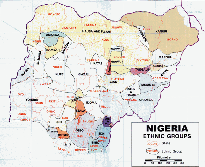
Two major ethnic groups, the Hausa and Fulani, make up most of Kano State's population. Like most parts of northern Nigeria, Hausa is the state's dominant language. Kano State has faced attacks by the Islamist terrorist group Boko Haram, inter-religious violence, and extreme poverty. The state observes Sharia law within the legal framework of the Nigerian constitution.
History
Kano State was the site of a number of kingdoms and empires which included the Kingdom of Kano, centred on Dalla Hill (Hausa: Dutsen Dala) from to 1000 to 1349 CE. In 1349, the Sultanate of Kano was established when Yaji I converted to Islam and became its first sultan. Kurmi Market, which opened in 1463, helped the city of Kano become a centre of commercial activity in Hausaland. The market remains open, and its historic importance is reflected in the state's nickname: Centre of Commerce.
During the 16th and 17th centuries, the Sultanate of Kano became one of the most powerful Hausa Kingdoms. After the 1804–1808 Fulani jihad, the Kano Emirate replaced the former sultanate. Emir Ibrahim Dabo made a number of administrative reforms to increase commerce in the region. Leaders encouraged traders to move from Katsina, capitalising on raids from the Hausa Sultanate of Maradi.
The British Empire conquered the Kano Emirate in 1903, incorporating it into the Northern Nigeria Protectorate. The major ethnic groups in pre-colonial Kano were the Hausa, Fulani, Barebari (Kanuri), Tuareg, Arabs, and Nupe. Most people in Kano speak Hausa as a first language, and some identify as ethnically Hausa.
Kano State has a diverse economy, establishing itself as a centre of industry, agriculture, and Islamic banking. The state was created on 27 May 1967, and part of it became Jigawa State in 1991.
Geography
Climate
The rainfall in Kano State varies, with drought and near-drought conditions during the 1970s and 1980s. Moisture conditions improved from the 1990s to 2015, but rainfall still fluctuated. Since 2015, there has been an increase in rainfall. According to a Nigerian Meteorological Agency (NIMET) report, rainfall averages 897.7 mm (35.34 in).
NIMET issued a flood warning for some states, including Kano, during the first quarter of 2022. Their warning was based on the amount and distribution of nationwide rainfall during the rainy season. According to the Kano State Emergency Management Agency (SEMA), 25 local government districts experienced flooding.
Temperature
Kano's temperature has risen significantly since the 1960s. The state's annual diurnal temperature is between 26 and 30 °C (79 and 86 °F), and humidity ranges from 17 to 90 percent.
Economy
Kano has a number of large markets, including Kurmi Market, Kantin Kwari Market, Sabon Gari Market, Dawanau Market, Kofar Wanbai Market, Galadima Market, Yankura Market and Bata Market. Many markets specialise in certain products such as textiles or grain. Since the 19th century, the dye industry has contributed to Kano's economy.
Agriculture
Subsistence and commercial agriculture are primarily practised in the state's outlying districts. Food crops include millet, cowpeas, sorghum, maize and rice for local consumption, and groundnuts and cotton are produced for export and industry. During the colonial period and several years after the country's independence, the groundnuts produced in the state constituted one of the major sources of revenue of the country. Kano State is a major producer of hides and skins, sesame, soybeans, cotton, garlic, gum arabic and chili peppers. A 2018 study of Tudun Wada found that temperature and rainfall were likely to increase with climate change (placing increased stress on crops), and would require adaptation of agricultural practices.
Industry
Kano State is Nigeria's second-largest industrial centre, after Lagos State, and the largest in northern Nigeria. Industries include textiles, tanning, footwear, cosmetics, plastics, enamelware, pharmaceuticals, ceramics, furniture, agricultural implements, soft drinks, food and beverages, dairy products, vegetable oil, and animal feed. Kano is the centre of a growing Islamic banking industry in Nigeria.
Tourism
Tourist attractions in the state include:
- Kurmi Market, established in the 15th century
- Kano's city wall
- Gidan Rumfa (the emir's palace)
- Kano Zoo
- Dalla and Gwauron Dutse Hills
- Kano Museum
- Bashir Tofa mosque
- Gidan dan Hausa Museum
 Gidan Dan Hausa Museum
 Gidan Rumfa
 Kano Museum
 Bashir Uthman Tofa Mosque
 Kano Emirate palace


Natural resources
Kano State has a variety of natural resources, including the minerals cassiterite, copper, gemstones, glass sand, lead, zinc and tantalite.
Transport
Roads
Federal highways
- A2 (part of the Trans-Sahara Highway, or TAH 2) north from Kaduna State at Gidan Mallam Idi for 166 kilometres (103 mi) as Zaria Road via Kura, Nassarawa, Kano, Bankaura, Kunya, Dambarta and Ajumawa to Jigawa State at Yanzaki
- A9 (part of the Dakar-Ndjamena Trans-Sahelian Highway, or TAH 5) northwest from A2 at Bankaura, 14 kilometres (8.7 mi) north of Kano City for 71 kilometres (44 mi) via Bichi, Dan Zabuwa and Tsanyawa as IBB Way to Katsina State at Yan Kamaye
- A237, continuing the TAH 5 east from A2 in Kano for 110 kilometres (68 mi) across the Hadejia River at Wudil via Takai and Kachako to Jigawa State as Kano Road
Other major roads
- The Kunya-Mutum road northeast from the A2 to Jigawa State at Duma
- The Kano-Gumel road northeast via Dosai, Gezawa, Kirazare and Dadin Diniya to Jigawa State, near Magama
- The Kano-Ringim road east from Dosai via Gwandu, Wangara, Zugachi and Zakirai to Jigawa State at Gorshinsi
- South from Gwandu via Gogel to the A237 at Zogarava
- The Gaya-Wudil Road east from the A237 to Jigawa at Dundubis as the Gaya-Azare Road
- South from the A2 at Karfi Ruga as the Kano-Kumbotso-Rano (or Rano-Karfin Ruga) Road via Bunkure, Rano, Kibiya, Tarai, Burunburum, Sitti and Masu to Bauchi State at Gwanda as the Sabon Gari-Gwanda-Kafin-Birgi Road
- The Kafin Maiyaki-Sabin Bimi Road south from the A2 via Arna, Tudun Wada, Falgore Game Reserve, Tagwaye and Dadin Kowa to Kaduna State at Murai
- The Kiru-Rurum Road north from the A2 at Kafin Maiyaki via Yako and Karaye to Gwarzo as the Kafi-Jamaa Kosa Road
- Murtala Mohammed Road west from Kano city to Katsina State at Gangara
- The Gwarzo-Shanono Road north via Bagawi to the A9 at Bichi
Railways
Kano is on the 1067 mm Cape-gauge Western Railway line from Lagos via Kaduna to Jigawa State (rehabilitated in 2013), with a double-track standard-gauge line proposed in 2025.
Airport

Mallam Aminu Kano International Airport, built in 1936, is the headquarters of Kabo Air, Azman Airlines and Max Air.
Education
Secondary schools
Universities
Kano State has five universities: one federal university, one regimented federal university, two state universities, and one private university.
- Bayero University Kano (BUK), founded in 1977
- Kano University of Science and Technology (KUST), founded in 2001
- Nigeria Police Academy Wudil, founded as Nigeria's 37th federal university in 2011
- Northwest University, Kano (YUSMUK), founded in 2012
- Skyline University, Kano, founded in 2018
Polytechnics and colleges
Local government areas
Kano State has 44 local government areas (LGAs).
| Name | Area (km2) | Population (2006) | Administrative capital | Postal code |
|---|---|---|---|---|
| Fagge | 21 | 200,095 | Waje | 700 |
| Dala | 19 | 418,759 | Gwanmaja | 700 |
| Gwale | 18 | 357,827 | Gwale | 700 |
| Kano Municipal | 17 | 371,243 | Kofar Kudu | 700 |
| Tarauni | 28 | 221,844 | Unguwa Uku | 700 |
| Nassarawa | 34 | 596,411 | Bompai | 700 |
| Kumbotso | 158 | 294,391 | Kumbotso | 700 |
| Ungogo | 204 | 365,737 | Ungogo | 700 |
| Kano (metropolitan area) | 499 | 2,828,861 | 700 | |
| Dawakin Tofa | 479 | 246,197 | Dawakin Tofa | 701 |
| Tofa | 202 | 98,603 | Tofa | 701 |
| Rimin Gado | 225 | 103,371 | Rimin Gado | 701 |
| Bagwai | 405 | 161,533 | Bagwai | 701 |
| Gezawa | 340 | 282,328 | Gezawa | 702 |
| Gabasawa | 605 | 211,204 | Zakirai | 702 |
| Minjibir | 416 | 219,611 | Minjibir | 702 |
| Dambatta | 732 | 210,474 | Dambatta | 702 |
| Makoda | 441 | 220,094 | Makoda | 702 |
| Ghari | 671 | 110,170 | Kunchi | 703 |
| Bichi | 612 | 278,309 | Bichi | 703 |
| Tsanyawa | 492 | 157,730 | Tsanyawa | 703 |
| Shanono | 697 | 139,128 | Shanono | 704 |
| Gwarzo | 393 | 183,624 | Gwarzo | 704 |
| Karaye | 479 | 144,045 | Karaye | 704 |
| Rogo | 802 | 227,607 | Rogo | 704 |
| Kabo | 341 | 153,158 | Kabo | 704 |
| Northern Kano State | 8,332 | 3,143,899 | 701–704 | |
| Bunkure | 487 | 174,467 | Bunkure | 710 |
| Kibiya | 404 | 138,618 | Kibiya | 710 |
| Rano | 520 | 148,276 | Rano | 710 |
| Tudun Wada | 1,204 | 228,658 | Tudun Wada | 710 |
| Doguwa | 1,473 | 150,645 | Riruwai | 710 |
| Madobi | 273 | 137,685 | Madobi | 711 |
| Kura | 206 | 143,094 | Kura | 711 |
| Garun Mallam | 214 | 118,622 | Garun Mallam | 711 |
| Bebeji | 717 | 191,916 | Bebeji | 711 |
| Kiru | 927 | 267,168 | Kiru | 711 |
| Sumaila | 1,250 | 250,379 | Sumaila | 712 |
| Garko | 450 | 161,966 | Garko | 712 |
| Takai | 598 | 202,639 | Takai | 712 |
| Albasu | 398 | 187,639 | Albasu | 712 |
| Gaya | 613 | 207,419 | Gaya | 713 |
| Ajingi | 714 | 172,610 | Ajingi | 713 |
| Wudil | 362 | 188,639 | Wudil | 713 |
| Warawa | 360 | 131,858 | Warawa | 713 |
| Dawakin Kudu | 384 | 225,497 | Dawakin Kudu | 713 |
| Southern Kano State | 11,554 | 3,410,922 | 710 to 713 |
Demographics
According to the 2006 census, Kano State had a population of 9,401,288.[full citation needed] Based on National Bureau of Statistics data, Kano is Nigeria's most populous state; Lagos State is second. The state is primarily inhabited by Hausa and Fulani people.
| Year | Pop. | ±% |
|---|---|---|
| 1991 | 5,810,470 | — |
| 2006 | 9,401,288 | +61.8% |
| 2022 | 15,462,200 | +64.5% |
| source: | ||
Languages
The state's official languages are Hausa and Fulfulde.[failed verification]
Notable people
- Sani Abacha (1943–1998), 10th military head of state
- Ja'afar Mahmud Adam (1960–2007), Islamic scholar
- Dije Abdu Aboki, jurist and the first female Chief Judge of Kano State
- Nazifi Asnanic, Kannywood actor and musician
- Mubarak Bala, president of the Humanist Association of Nigeria, imprisoned for social-media comments about Islam
- Aminu Ala, Hausa-language musician and writer
- Aliko Dangote, business magnate, philanthropist, and Africa's wealthiest person
- Aminu Dantata, business magnate and philanthropist
- Aminu Ibrahim Daurawa, Islamic preacher
- Abdullahi Umar Ganduje, Kano State governor from 2015 to 2023
- Ahmad Sulaiman Ibrahim, Islamic preacher
- Nura M Inuwa, Hausa musician
- Ali Jita, Hausa musician
- Abduljabbar Nasiru Kabara, Islamic preacher
- Qaribullah Nasiru Kabara, Islamic preacher
- Aminu Kano, politician and educator
- Sheikh Ibrahim Khaleel, Islamic preacher
- Rabiu Kwankwaso, former state governor and Minister of Defence
- Murtala Muhammed, fourth military head of state (1975–1976)
- Abdul Samad Rabiu, business magnate, philanthropist, and Africa's sixth-wealthiest person
- Isyaku Rabiu, businessman
- Sanusi Lamido Sanusi, former Central Bank of Nigeria governor and 14th and 16th Emir of Kano[citation needed]
- Ibrahim Shekarau, former governor and minister of education (2003–2011)
- Barau Jibrin, Deputy President of the Nigerian Senate since 2023
- Yusuf Babangida Suleiman, member of the seventh, eighth and ninth Kano State Houses of Assembly
- Abdullahi Aliyu Sumaila, former Kano State Executive Council secretary, Permanent Secretary, Principal Secretary to the Kano State Governor, board chair of the Hadejia-Jama'are River Basin Development Authority and Kano State Television Corporation
- Abba Kabir Yusuf, state governor since May 2023
Politics
The capital city is Kano. Kano's state government is led by an elected governor who works closely with the state House of Assembly. Like all state governors, they are elected with a modified two-round system. To be elected in the first round, a candidate must receive a plurality of the vote and over 25 percent of the vote in at least two-thirds of the state's LGAs. If no candidate reaches this threshold, a second round of voting is held between the two highest-ranking candidates.
Gallery
 Kano council gate
 Shoptite mall
 Kwankwasiyya flyover
 Danbatta flyover
 Ruwa Gate
 Mazugal Gate
 Dawanau Gate
 Prince Audu Abubakar underpass
 Waika Gate
 Fishermen
 Famfo Gate
 House of Kadiriyya


See also
References
- ↑ See List of governors of Kano State for a list of prior governors
- ↑ "Kano State Population 2026". Retrieved 17 September 2026.
- 1 2 Okeowo, Gabriel; Fatoba, Iyanuoluwa, eds. (13 October 2022). "State of States 2022 Edition" (PDF). Budgit.org. BudgIT. Archived from the original (PDF) on 28 March 2024. Retrieved 7 March 2023.
{{cite web}}: More than one of|publication-date=and|date=specified (help) - ↑ "Sub-national HDI – Area Database – Global Data Lab". hdi.globaldatalab.org. Archived from the original on 23 September 2018. Retrieved 13 September 2018.
- 1 2 3 4 "About Kano". Kano State. 30 December 2017. Archived from the original on 19 May 2020. Retrieved 19 May 2020.
- ↑ "Kano/Katsina: Ganduje, Masari, Gaidam sworn-in – P.M. News". P.M. News. Lagos, Nigeria. Archived from the original on 4 February 2022. Retrieved 4 February 2022.
- 1 2 "Nigeria Ethnic Groups|Map". onlinenigeria.com. Archived from the original on 26 January 2021. Retrieved 17 September 2020.
- ↑ "Hausa Language Variation and Dialects". African Languages at UCLA. Archived from the original on 4 December 2020. Retrieved 14 March 2021.
- ↑ Adoti, Olive (30 July 2020). "10 Top languages spoken in Nigeria (plus the states)". Legit.ng. Archived from the original on 23 April 2021. Retrieved 14 March 2021.
- ↑ Nossiter, Adam (19 March 2013). "Bombs Strike Bus Station in Nigeria (Published 2013)". The New York Times. ISSN 0362-4331. Archived from the original on 18 March 2021. Retrieved 14 March 2021.
- ↑ "Nigeria suicide bombers target Potiskum and Kano buses". BBC News. 24 February 2015. Archived from the original on 29 August 2021. Retrieved 29 August 2021.
- ↑ "BBC News – Nigeria unrest: Kano mosque attack kills dozens". BBC News. 28 November 2014. Archived from the original on 29 November 2014. Retrieved 29 November 2014.
- ↑ Obasanjo Assesses Riot Damage in Kano – 2001-10-16 Archived 9 March 2026 at the Wayback Machine . Voice of America News.
- ↑ "Kano: Nigeria's ancient city-state". BBC online. BBC. 20 May 2004. Archived from the original on 18 May 2014. Retrieved 12 July 2007.
- ↑ "Geographies of poverty in Kano State: The role of GIS in identifying and mapping multidimensionally deprived households". ResearchGate. Archived from the original on 22 February 2022. Retrieved 14 March 2021.
- ↑ "Nigerian singer sentenced to death for blasphemy in Kano state". BBC News. 10 August 2020. Archived from the original on 9 May 2021. Retrieved 14 March 2021.
- ↑ "Kano State Government". 1 May 2010. Archived from the original on 1 May 2010. Retrieved 14 March 2021.
- ↑ "Hausa" (PDF). Archived (PDF) from the original on 22 February 2022. Retrieved 14 March 2021.
- ↑ "Kurmi: Kano's 600-year-old slave market now sanctuary for artifacts". Daily Trust. 19 October 2015. Retrieved 23 October 2023.
- 1 2 3 4 "Kano Markets". Kano State. 6 June 2018. Archived from the original on 19 May 2020. Retrieved 19 May 2020.
- ↑ "Kurmi Market Kano State :: Nigeria Information & Guide". www.nigeriagalleria.com. Archived from the original on 4 November 2023. Retrieved 23 October 2023.
- ↑ Ujorha, Tadaferua (9 May 2003). "Kano's 500-year-old market". Daily Trust. Biafra Nigeria World. Archived from the original on 7 August 2021. Retrieved 1 November 2007.
- ↑ "Embassy of the Federal Republic of Nigeria – History". nigeriaembassyusa.org. Archived from the original on 2 March 2021. Retrieved 14 March 2021.
- ↑ "Kano | Map, Location, History, & Facts | Britannica". Encyclopedia Britannica. Archived from the original on 11 March 2026. Retrieved 13 April 2026.
- ↑ Miers, Suzanne; Klein, Martin A. (1999). Slavery and Colonial Rule in Africa. Psychology Press. ISBN 978-0-7146-4884-2. Archived from the original on 4 August 2020. Retrieved 19 May 2020.
- ↑ "History – Kano State Government". Retrieved 16 January 2025.
- ↑ "The Fall of Kano | History Today". Archived from the original on 7 October 2021. Retrieved 14 March 2021.
- ↑ Paden (January 1973). Religion and Political Culture in Kano. University of California Press. ISBN 0-520-01738-2.
- 1 2 "Kano Metropolis". Archived from the original on 22 February 2022. Retrieved 27 August 2023..
- 1 2 "Islamic Finance Nigeria". SukFin. Archived from the original on 30 September 2020. Retrieved 7 May 2020.
- ↑ Buba, L. F. (2010). Spatio-temporal rainfall and temperature variation in northern Nigeria. A Ph.D. Thesis submitted to the Geography Department, Bayero University, Kano.
- ↑ Badamasi, M.M. (2014). Vegetation and Forestry in Tank, A.I. & Morale, S.B. (Eds.) Kano Government, Society and Development. London & Abuja: Adonis and Abbey Publishers.
- ↑ "Kano my state". www.kanodashboard.ng. Retrieved 4 October 2023.
- ↑ Maishanu, Abubakar Ahmadu (8 November 2022). "Special Report: Traders count losses as floods submerge West Africa's largest textile market in Kano". Premium Times. Retrieved 10 November 2022.
- ↑ Badamosi, M.M. (2014). Vegetation and Forestry in Tank A.I., Momale, S.B. (eds.) Kano Government, Society and Development. London & Abuja: Adonis and Abbey Publishers.
- ↑ Kowal & Knabe, J.M. & D.T. (1972). An agroclimatological atlas of northern states of Nigeria with explanatory notes. Zaria: ABU Press.
- ↑ Olofin, E.A. (1987). Some aspects of the physical geographies of the Kano region and related human responses: Departmental lecture notes. Kano, Nigeria: Denis Standard Printers.
- ↑ "Kantin Kwari market Archives". The Guardian. Lagos, Nigeria. Retrieved 30 December 2022. [dead link]
- ↑ "Dawanau:46-Yr-Old Kano Market That Determines Cost Of Grains In Nigeria". Daily Trust. 7 November 2018. Retrieved 12 September 2023.
- ↑ Iweze, Daniel Olisa (2021). "THE DYE INDUSTRY AND ECONOMIC PROSPERITY OF KANO IN THE 19th CENTURY". Journal of the Historical Society of Nigeria. 30.
- ↑ "Ease of Doing Business: Kano State Govt. woos investors with land". BusinessDay. Lagos, Nigeria. 24 August 2017. Retrieved 21 October 2023.
- ↑ Garba, J.I. (2018). "Awareness and Adaptation Strategies to Climate Change in Tudun Wada Local Government Area of Kano State". Zaria Geographer. 25 (1): 63–75. ISSN 2782-7739.
- ↑ "Archived copy" (PDF). Archived (PDF) from the original on 9 September 2021. Retrieved 21 February 2021.
{{cite web}}: CS1 maint: archived copy as title (link) - ↑ "Nigeria: cities with the largest population 2020". Statista. Archived from the original on 21 February 2021. Retrieved 21 February 2021.
- ↑ Kasim Madugu, Yusuf. "Collapse of Textile Industry in Nigeria: A Study of Kano State, Nigeria" (PDF). Archived from the original (PDF) on 24 September 2021. Retrieved 27 August 2023.
- ↑ "Nigeria biannual economic update: connecting to compete" (PDF). World Bank. Archived (PDF) from the original on 4 May 2021. Retrieved 22 February 2022.
- ↑ "Kano". BBC News. Archived from the original on 9 May 2021. Retrieved 21 February 2021.
- ↑ "Why is business suffering in Kano?". BBC News. Archived from the original on 22 February 2022. Retrieved 21 February 2021.
- ↑ "Kurmi market - Daily Trust - Latest News in Nigeria and the World". Daily Trust. Retrieved 30 December 2022.
- ↑ "Google Travel". www.google.com.ng. Retrieved 30 December 2022.
- ↑ "Kano Zoo: Shortage of animals, unkept environment bother visitors". Daily Trust. 27 November 2020. Archived from the original on 30 December 2022. Retrieved 30 December 2022.
- ↑ "Goron Dutse Hill | hill, Nigeria | Britannica". www.britannica.com. Retrieved 30 December 2022.
- ↑ Webmaster (23 December 2012). "Gidan Makama: The Story of Kano's Famous Museum". Daily Trust. Retrieved 30 December 2022.
- ↑ "Natural Resources – Welcome To The Embassy of Nigeria". Archived from the original on 26 January 2022. Retrieved 4 February 2022.
- ↑ "Railway Line: Kano-Maradi". Team Group. Archived from the original on 26 January 2025. Retrieved 16 January 2025.
- ↑ "Malam Aminu Kano International Airport (MAKIA)". Daily Trust. Retrieved 23 October 2023.
- ↑ "Mallam Aminu Kano International Airport News | Latest news about Mallam Aminu Kano International Airport today, 23 October 2023". Naija News. Retrieved 23 October 2023. [dead link]
- ↑ "HISTORY OF DAWAKIN TOFA SCIENCE COLLEGE KANO STATE". datsosa2000.weebly.com. Archived from the original on 22 February 2022. Retrieved 14 September 2021.
- ↑ "Science and Technical Schools Board". www.stsbkano.ng. Archived from the original on 14 June 2021. Retrieved 19 May 2021.
- ↑ "History, Facts & Figures | Bayero University, Kano". buk.edu.ng. Archived from the original on 19 May 2020. Retrieved 19 May 2020.
- 1 2 "Brief History of Kust Wudil – Kano University of Science and Technology, Wudil". Archived from the original on 5 July 2020. Retrieved 19 May 2020.
- ↑ "Nigeria Police Force". www.npf.gov.ng. Archived from the original on 4 March 2021. Retrieved 28 March 2021.
- ↑ sun.edu.ng Skyline University
- ↑ "Local Government in Kano State: Full List of 44 LGAs & Headquarters (2026)". Real Estate in Nigeria. Retrieved 18 June 2026.
- ↑ "Demographic Statistics Bulletin 2020". Archived from the original on 8 May 2024. Retrieved 26 May 2023.
- ↑ "Rejections greet census result". Vanguard. Lagos, Nigeria. Archived from the original on 29 January 2007. Retrieved 28 August 2023.
- ↑ "Nigeria: States & Agglomerations – Population Statistics, Maps, Charts, Weather and Web Information". www.citypopulation.de. Archived from the original on 8 July 2019. Retrieved 2 July 2019.
- ↑ Ibrahim Ado-Kurawa (2003). "Brief History of Kano 999 to 2003". kanostate.net. Kano State Government Nigeria. Archived from the original on 10 December 2009. Retrieved 7 December 2009.
- ↑ "Details - Council Members Details". nji.gov.ng. Retrieved 2 September 2026.
- ↑ Khalid, Ishaq (5 April 2022). "Nigeria atheist Mubarak Bala jailed for blaspheming Islam". BBC.
- ↑ "Aliko Dangote". Forbes. Archived from the original on 27 June 2012. Retrieved 30 December 2022.
- ↑ "Aliko Dangote". Forbes. 16 February 2024. Retrieved 16 February 2024.
- ↑ Uwechue, Raph (1991). Makers of Modern Africa (Second ed.). United Kingdom: Africa Books Limited. pp. 323–324. ISBN 0903274183.
- ↑ "Rabiu Kwankwaso family, wife, children, parents, siblings". 20 February 2023. Retrieved 26 December 2023.
- ↑ "Abdul Samad Rabiu". Forbes. Archived from the original on 27 May 2023. Retrieved 28 May 2023.
- ↑ "Abdul Samad Rabiu". Forbes. 16 February 2024. Retrieved 16 February 2024.
- ↑ "Abdulsamad Rabiu: Exploring the journey of Nigeria´s silent billionaire @ 60". Nairametrics. 4 August 2020. Retrieved 28 June 2021.
- ↑ "Glad Tidings! Billionaire Industrialist Abdul Samad Rabiu Is 60". This Day. 9 August 2020. Retrieved 28 June 2021.
- ↑ Quadri, Opeyemi (9 May 2022). "List Of CBN Governors From 1958 Till Date". infomediang.com. Retrieved 30 December 2022.
- 1 2 Oguntola, Tunde (27 September 2022). "2023: Next President, Govs Must Get Two-thirds Spread, Says INEC". Leadership. Archived from the original on 23 February 2023. Retrieved 23 February 2023.
Further reading
- "Commercial Agriculture Development Project (CADP)". 2010. Archived from the original on 21 September 2014. Retrieved 3 March 2013.
External links


 Media related to Kano State at Wikimedia Commons
- National Bureau of Statistics Maps of Kano State
State capital: Kano | ||
| Local government areas |
|  |
| North Central |  | |
|---|---|---|
| North West | ||
| North East | ||
| South East | ||
| South South | ||
| South West | ||
| ||

| International | |
|---|---|
| National | |
| Geographic | |
| People | |
| Other | |