| This is an archive of past discussions on Wikipedia:Graphics Lab, for the period 2020. Do not edit the contents of this page. If you wish to start a new discussion or revive an old one, please do so on the current main page. |
Maps of Lochaber
Hi Folks!! I'm looking to find some kind of map of the Rhu Peninsula. It is a small peninsula and completely ignored so far. It has centuries of history for such a small place. The location can be found from the article. I tried to get a map from OpenStreetMap but couldn't. Anyhelp is appreciated. Thanks. scope_creepTalk 17:22, 11 August 2021 (UTC)
 Request taken by --always ping me-- Goran tek-en (talk) 15:37, 28 September 2021 (UTC).
scope_creep Those drafts are PNG versions of the original SVG file I'm working in and will upload to commons.
For the ones called "map" there should be another color of the land which is "outside of main interest" eg main land. But I don't know where to draw it. So if you want it you have to tell me/show me.
I can remove/add any of what's in those drafts. If you want names there you will have to write them here and tell me where to put them.
56.901746, -5.856653 Camas an T-Salainn
56.900107, -5.865492 Port a Mhuilim
56.901902, -5.872618 Sgeirean Buidhe
56.903428, -5.901536 South Channel
56.909281, -5.883173 Loch nan Ceall
56.891859, -5.934538 Rubh’ Arisaig
56.881787, -5.931534 Eilean Port nam Murrach
56.874841, -5.914583 Port a' Bhàthaich
56.871773, -5.899019 Eilean a' Ghaill
56.870272, -5.890094 Camas Drollaman
56.881785, -5.865980 Camas Leathann
56.881785, -5.865980 Car an Daimh
56.882207, -5.835516 Camas Ghaoideil
56.902563, -5.893229  Tòrr Mòr
56.890686, -5.907655 Neolithic carved stone
56.892995, -5.828741 Cup marked stone
56.886460, -5.894208, Cruach Doire an Dòbhrain
56.886366, -5.894380 hill point. This is just a dot.
56.885856, -5.846306 Doire Fhada (show almost vertically a slight inclination to the right)
56.895148, -5.875359 Loch a' Mhuilinn
56.887557, -5.878363 Loch Doire Ghioghain
56.883666, -5.883942 Coire Camas Drollaman
56.889665, -5.862570 Loch Torr a' Bheithe
56.889665, -5.862570 Loch Dubh
56.896320, -5.846963 Druim an Dubh-leathaid
56.888207, -5.914734  Rhue Cott.
56.903456, -5.901170South channel
56.898518, -5.891041 Rhumach
56.897768, -5.873532 Millburn Cott
See how that looks. scope_creepTalk 22:09, 6 October 2021 (UTC)
scope_creepTalk 21:11, 8 October 2021 (UTC)
Apart from that. Map 1 and 2. The deep forest wee icons are visually attractive and better than the base green.
scope_creepTalk 14:57, 11 October 2021 (UTC)
Thats every. That fills in the corner, the top and island. 21:56, 12 October 2021 (UTC)
scope_creep I will need the following for each of the files;
to be able to upload it at commons. If you don'y know about Captions read here. --always ping me-- Goran tek-en (talk) 18:13, 14 October 2021 (UTC) @Goran tek-en: How about
scope_creepTalk 18:33, 14 October 2021 (UTC)
scope_creep Now you can find them here Commons:file:Rhu Peninsula map 1.svg, Commons:file:Rhu Peninsula elevated thematic map 1.svg, Commons:file:Rhu Peninsula map 1 location legend.svg, Commons:file:Rhu Peninsula elevated thematic map 1 location legend.svg. If you are happy with this please put the code {{re.solved|~~~~}} (without the ".") on this request so it can be archived, thanks.  Done --always ping me-- Goran tek-en (talk) 15:59, 15 October 2021 (UTC)

Battle of Oroscopa is at FAC and it has been suggested that the information on the second map - File:Carthage location 2.png - which is just the position of Carthage, could be transferred to a version of the first map - File:Map of kingdom of numidia ancient algeria (cropped).png - and the location of Rome added. In an ideal world the map would also be tidied up a little to look more professional and in a perfect world, shading added to show territory controlled by Carthage and Rome. Thanks. Gog the Mild (talk) 13:57, 5 October 2021 (UTC)
@Gog the Mild: I can help you but I will need your help and knowledge in the process, will you be here? --always ping me-- Goran tek-en (talk) 15:40, 21 October 2021 (UTC)
Request taken by --always ping me-- Goran tek-en (talk) 17:01, 21 October 2021 (UTC).
If possible, yes please - three areas. I am not really understanding the "overlap" query. There is no overlap. Possibly you could rephrase the question?
Gog the Mild I will need the following; Goran tek-en:
Gog the Mild Now you can find it here Commons:file:Western Mediterranean territory, 150 BC.svg. If you are happy with this please put the code {{re.solved|~~~~}} (without the ".") on this request so it can be archived, thanks. Done --always ping me-- Goran tek-en (talk) 17:03, 24 October 2021 (UTC)
{{resolved}}
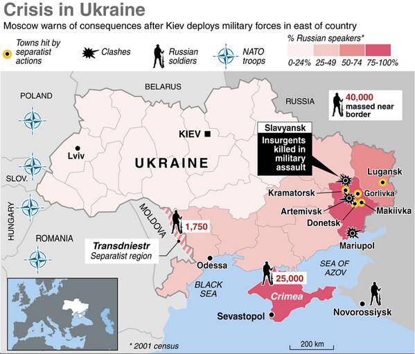
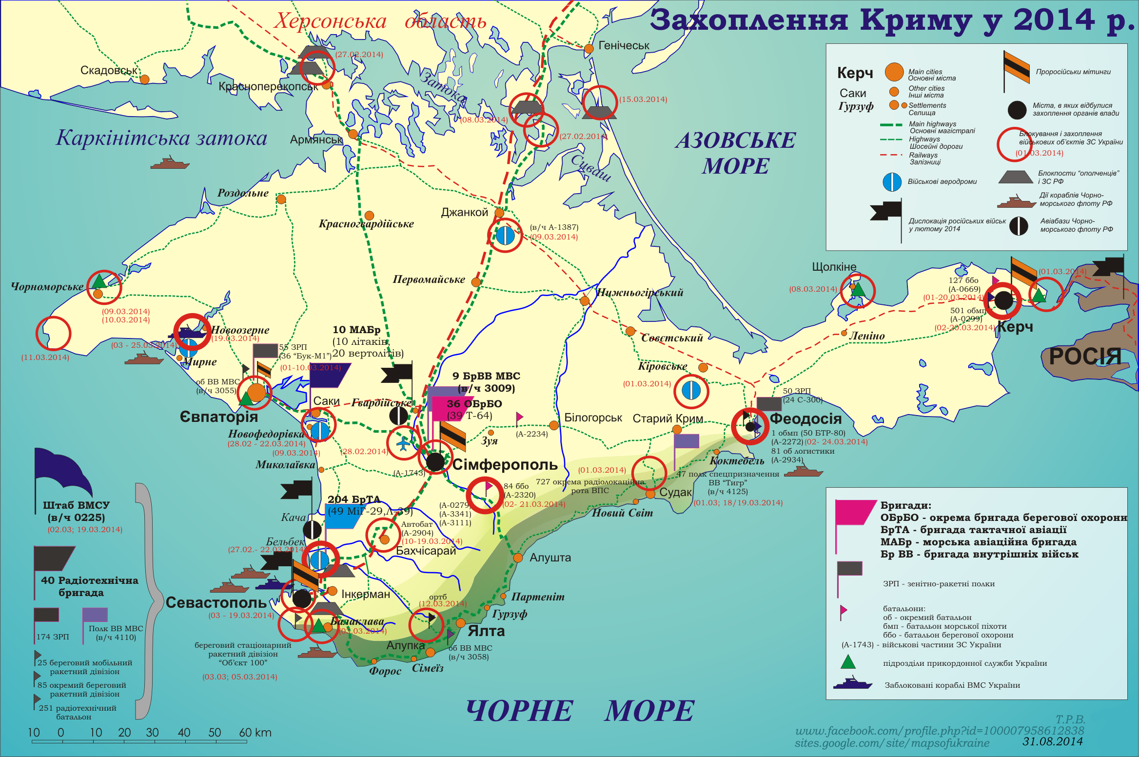
Article: Russo-Ukrainian War
Request: Hi can anyone rise to the challenge of making a map for the Russo-Ukrainian conflict. We have many maps of territorial changes in the east over the month-years, but nothing detailed in English that gives an overview of the operation in Crimea and the situation in East. I have compiled some map resources that might be of use in making those maps.
Thanks. --Jakey222 (talk) 14:52, 10 October 2021 (UTC)
Request taken by --always ping me-- Goran tek-en (talk) 16:52, 10 October 2021 (UTC).
Extended content |
|---|
|
@Jakey222: Thanks for putting in information so we have something to work from.
@Jakey222:, @Mzajac: Yes please create lists of what to put in the maps. I need that information straight on, not a lot of contexed text, it only makes me confused. When you answer my questions please just stay to the actual question.
This is not wikipedia, at commons there are different "rules" regarding sources and stuff like that but we don't have to prove that something is true, but we need to show where we got the information from. --always ping me-- Goran tek-en (talk) 11:40, 11 October 2021 (UTC) There’s another bare-bones map of Crimea in Galeotti 2019, p 10. —Michael Z. 16:00, 11 October 2021 (UTC) @Goran tek-en: The list of locations would depends on the style of map and level of detail you are aiming for. The first reference map I linked above outlines pretty well all the location that has been mentioned in media and various articles here. Here is another one(source,p11) and list of all the location you might use with their spelling on Wikipedia:
Note: marker for Donuzlav Bay should probably be used instead of Novoozerne (as the location for the blockade of the Ukrainian fleet in Donuzlav) and I seen no info on the precise location of Checkpoints except that they are near Armyansk, Chonhar. @Mzajac: Do you have any preference/sources/concerns about which location are due for inclusion? --Jakey222 (talk) 17:06, 11 October 2021 (UTC)
Jakey222 I understand you are busy elsewhere and I don't mean to push you but, I do need your feedback and help per above to be able to continue on your request. --always ping me-- Goran tek-en (talk) 11:28, 26 October 2021 (UTC) |
 Stale
--always ping me-- Goran tek-en (talk) 13:30, 1 November 2021 (UTC)
Goran tek-en, sorry I haven’t been active here. I happened to stumble on some resources useful for the eastern Ukraine basemap, and I’ll link to them in case you’re still working on this.
Could also be useful to update File:Minsk Protocol.svg.
—Michael Z. 23:49, 8 December 2021 (UTC)
 Checking... — Berrely • Talk∕Contribs 16:17, 23 August 2021 (UTC)
.map file hosted on the Commons, Data:Interstate 70.map, although you would need to convert the KLM files to JSON. – BrandonXLF (talk) 01:43, 25 August 2021 (UTC)
Hey folks, I've been noticing related issues where the map appears like a broken image on first view but when you preview an edit, it shows. This is all even after purging the cache. – The Grid (talk) 17:35, 31 August 2021 (UTC)
{{Maplink-road}}. From there, it's supposed to talk to OSM via Wikidata and display data that way, then T289346 is the ticket we need to follow. That being said, maps that are hosted on Commons or raw GeoJSON data on enwiki have been working fine for me, personally. –Fredddie™ 01:46, 3 September 2021 (UTC)
{{Maplink-road}} doesn't appear to me to be blank in that article. Meh. I'm not gonna add route maps to articles if they're just going to show a world map... TerraFrost (talk) 21:30, 4 September 2021 (UTC)
I just noticed many highways in NY are just showing a world map, New York State Route 840 and New York State Route 3A are examples. Seems to be related. Just mentioning this here. MB 21:49, 20 September 2021 (UTC)
I have been making an article about a Dark Age Welsh poem called Dinogad's Smock. In the poem there is mention of a river called Derwennyd, which is thought to represent one of the rivers called Derwent in northern England, probably the Durham Derwent or the Cumbrian Derwent. I was looking at how to make a map which would signal both of them, but couldn't work it out. Maybe with their courses highlighted, but not sure if that is wp policy or not.
Any help or advice would be really gratefully received. Boynamedsue (talk) 08:35, 23 October 2021 (UTC)
Request taken by --always ping me-- Goran tek-en (talk) 16:00, 27 October 2021 (UTC).
forgot to ping @Goran tek-en:Boynamedsue (talk) 16:48, 31 October 2021 (UTC)
Boynamedsue Draft-3, with legend and names.
to be able to upload it at commons. If you don'y know about Captions read here. --always ping me-- Goran tek-en (talk) 19:50, 2 November 2021 (UTC)
@Goran tek-en: Sorry for the delay in responding, I have lots of work on at the moment, thanks for all your effort on this. I will get back to you with the details you need soon, hopefully. Boynamedsue (talk) 08:26, 4 November 2021 (UTC)
Boynamedsue Now you can find it here Commons:file:The Cumbrian and Durham Derwents.svg.
{{re.solved|~~~~}} (without the ".") on this request so it can be archived, thanks. Done --always ping me-- Goran tek-en (talk) 11:07, 9 November 2021 (UTC)Thanks again Goran, I very much appreciate your patience and work. Boynamedsue (talk) 14:43, 9 November 2021 (UTC)
{{resolved}}
Hi Wikipedia users,
Being passionate about maps, but a chimp at programming and coding, I would like to request an orthopedic projection of the earth centered on -10.617562, -109.674952. The surrounding continents and landmasses can be the default grey used for other such maps of its kind. If it isn't too much work for someone with experience, the help would be greatly appreciated, thanks! — Preceding unsigned comment added by Mute0O0 (talk • contribs) 02:22, 9 September 2021 (UTC)
 Request taken by --Guerillero Parlez Moi 10:57, 11 November 2021 (UTC).
@Guerillero – It looks great, just few suggestions.
Thanks a lot for making the map. The above points are just suggestions, and the map in its current form is what I consider better than excellent! You clearly have put a lot of effort. Thanks! – Kavyansh.Singh (talk) 09:42, 13 November 2021 (UTC)