Tam Long
 | You can help expand this article with text translated from the corresponding article in Vietnamese. Click [show] for important translation instructions.
|
Tam Long
Phường Tam Long Hòa Long, Long Kiên, Long Xuyên, Long Phước | |
|---|---|
 Hòa Long Market | |
 Interactive map of Tam Long | |
| Coordinates: 10°31′18″N 107°12′26″E / 10.52167°N 107.20722°E | |
| Country |  Vietnam |
| Municipality | Ho Chi Minh City |
| Established | June 16, 2025 |
| Area | |
• Total | 13.40 sq mi (34.70 km2) |
| Population (2024) | |
• Total | 41,130 |
| • Density | 3,070/sq mi (1,185/km2) |
| Time zone | UTC+07:00 (Indochina Time) |
| Administrative code | 26572 |
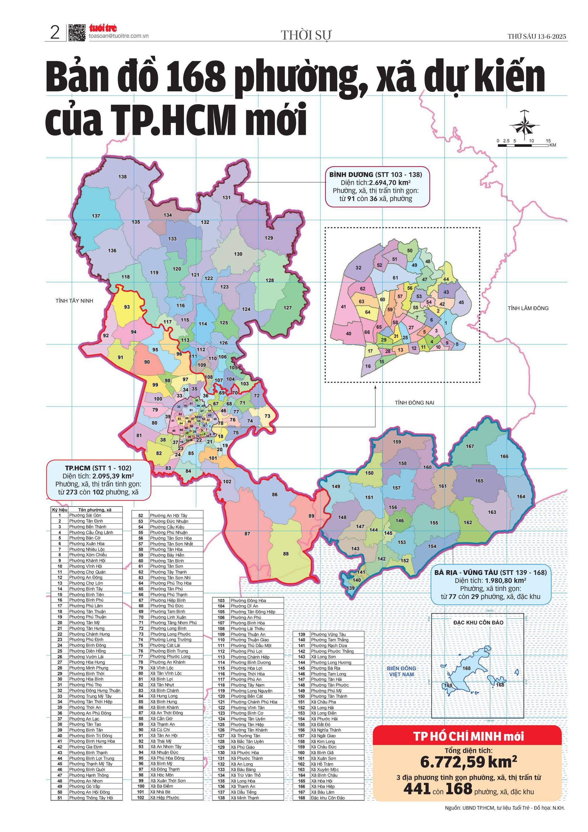
Tam Long (Vietnamese: Phường Tam Long) is a ward of Ho Chi Minh City, Vietnam. It is one of the 168 new wards, communes and special zones of the city following the reorganization in 2025.
Geography
Tam Long is located roughly 60 kilometers southeast of Saigon and roughly 25 kilometers east of Vũng Tàu, it borders the following wards and communes:
- To the north, it borders Nghĩa Thành.
- To the west, it borders Long Hương and Bà Rịa.
- To the south, it borders Long Điền.
- To the east, it borders Đất Đỏ.
According to Official Dispatch No. 2896/BNV-CQĐP dated May 27, 2025 of the Ministry of Home Affairs, following the merger, Tam Long has a land area of 34.70 km², the population as of December 31, 2024 is 41,130 people, the population density is 1,185 people/km².
Administration
Tam Long Ward is divided into 17 neighborhoods: 1, 2, 3, 4, 5, Bac 1 Hoa Long, Bac 2 Hoa Long, Bac 3 Hoa Long, Bac Long Phuoc, Dong Hoa Long, Dong Long Phuoc, Nam Hoa Long, Nam Long Phuoc, Phong Phu, Phuoc Huu, Tay Hoa Long, and Tay Long Phuoc.
History
On June 16, 2025, the National Assembly Standing Committee issued Resolution No. 1685/NQ-UBTVQH15 on the arrangement of commune-level administrative units of Ho Chi Minh City in 2025 (effective from June 16, 2025). Accordingly, the entire land area and population of Long Tâm ward and Hòa Long, Long Phước communes of the former Bà Rịa city will be integrated into a new ward named Tam Long (Clause 108, Article 1).
Agency headquarters
Headquarters of various agencies in Tam Long Ward:
- Headquarters of the People's Committee, People's Council, and Public Administrative Service Center: **237 Provincial Road 52** (formerly the People's Committee of Hoa Long Commune)
- Ward Police Headquarters: **100 Hoang Hoa Tham** (formerly the Long Tam Ward Police)
- Headquarters of the Ward Party Committee and the Ward Vietnam Fatherland Front Committee: **567 Vo Van Kiet** (formerly the Long Tam Ward People's Committee)
- Ward Military Command: **Provincial Road 52** (formerly the People's Committee of Long Phuoc Commune)
Relics
- Long Phước Tunnels
Gallery
 A road in Tam Long ward

References
- ↑ "QUỐC HỘI THÔNG QUA NGHỊ QUYẾT SẮP XẾP ĐƠN VỊ HÀNH CHÍNH CẤP TỈNH". xaydungchinhsach.chinhphu.vn (in Vietnamese). Chính phủ Việt Nam. 2025-06-18. Retrieved 2025-06-22.
- 1 2 3 "Danh mục đơn vị hành chính cấp xã sau sắp xếp cấp tỉnh, cấp xã năm 2025" (PDF).
- ↑ "Quyết định số 19/2025/QĐ-TTg của Thủ tướng Chính phủ: Ban hành Bảng danh mục và mã số các đơn vị hành chính Việt Nam" (PDF). Viet Nam Government Portal.
- ↑ ONLINE, TUOI TRE (2025-06-16). "Chi tiết mới nhất về 168 phường, xã của TP.HCM sau sáp nhập". TUOI TRE ONLINE (in Vietnamese). Retrieved 2025-12-12.
- ↑ Báo Pháp Luật TP. Hồ Chí Minh (2025-06-25). "Tra cứu chi tiết 3.321 phường, xã, đặc khu của 34 tỉnh, Thành phố sau sắp xếp lại bộ máy". Báo Pháp Luật TP. Hồ Chí Minh (in Vietnamese). Archived from the original on 2025-10-09. Retrieved 2025-12-12.
- ↑ "Bản đồ 168 phường, xã dự kiến của TP.HCM mới".
- ↑ Báo, Nhân Dân điện tử (2025-05-07). "[Interactive] Các đơn vị hành chính cấp xã của TP Hồ Chí Minh được sắp xếp ra sao". Báo Nhân Dân điện tử (in Vietnamese). Retrieved 2026-01-26.
- ↑ Ủy ban bầu cử phường Tam Long (2026-02-11). "Nghị quyết số 3/NQ-UBBC về việc Công bố danh sách chính thức những người ứng cử đại biểu Hội đồng nhân dân phường Tam Long, nhiệm kỳ 2026 - 2031 theo từng Đơn vị bầu cử". Tam Long ngày mới - Thành phố Hồ Chí Minh. Archived from the original on 2026-05-15. Retrieved 2026-05-15.
- ↑ "Toàn văn Nghị quyết số 1685/NQ-UBTVQH15 sắp xếp các ĐVHC cấp xã của Thành phố Hồ Chí Minh năm 2025". Viet Nam Government Portal.
- ↑ "Địa Đạo Long Phước - Bản anh hùng ca cách mạng". Báo Bà Rịa - Vũng Tàu. 2019-12-30.
 | This article about a location in Ho Chi Minh City, Vietnam is a stub. You can help Wikipedia by adding missing information. |