Planning for light rail along I-205 began in the mid-1980s with an initial proposal for a route connecting Portland International Airport and Clackamas Town Center via the I-205 busway. Over the following decade, plans shifted from the I-205 corridor and culminated in the South/North Corridor project, which failed to secure voter-approved funding in multiple ballot measures. In 2001, the project was partially revived as the two-phased South Corridor Transportation Project, which proposed light rail along I-205 and the Portland Transit Mall in its first phase. The I-205/Portland Mall Light Rail Project was approved in 2003, and construction began in early 2007. The Portland Transit Mall segment opened on August 30, 2009, followed by the I-205 segment and the launch of Green Line service on September 12, 2009.
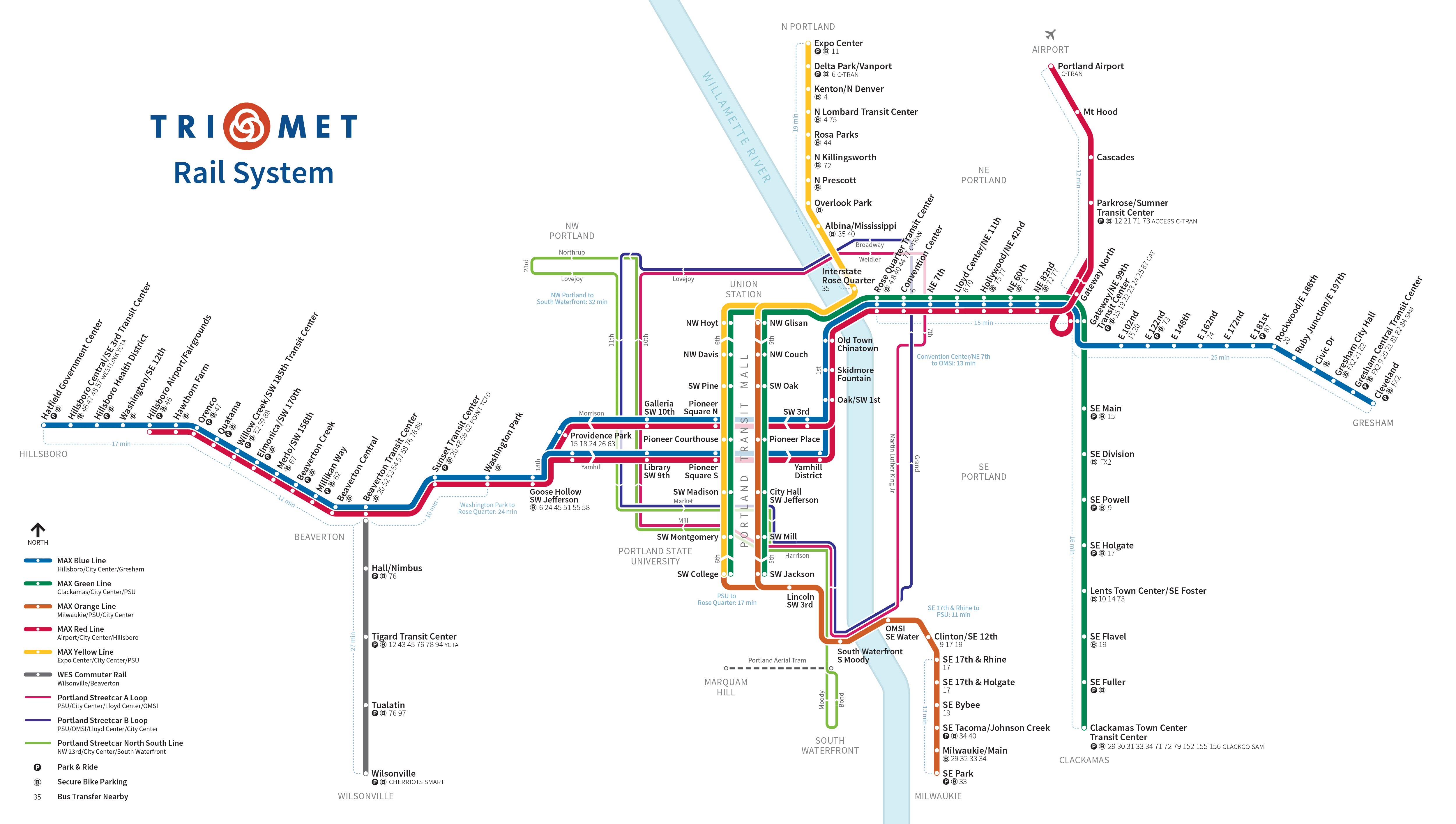
On August 23, 2026, the Green Line was shortened to operate only between Gateway Transit Center and Clackamas Town Center Transit Center as part of systemwide service cuts to TriMet, making it the only MAX line that does not serve downtown Portland.
A dispute between Washington and Clackamas county officials followed, with Clackamas County vying for additional federal assistance, including $17million in excess funds sourced from the partially realized I-205 busway. In an effort to settle the dispute, Metro updated its regional transportation plan (RTP) in January 1989 to reassert the westside line's priority and commission preliminary work for the I-205 and McLoughlin Boulevard proposals. The U.S. Senate Committee on Appropriations approved a financing package later in September, which provided $2million to assess the two segments, but at the behest of U.S. SenatorsMark Hatfield of Oregon and Brock Adams of Washington, who were members of the committee, a segment further north to Clark County, Washington became part of the proposals.
Alignment studies initially examined extending the proposed I-205 route further north across the Columbia River to Vancouver Mall or the Clark County Fairgrounds. As the studies analyzed various alternative routes, however, support shifted to an alignment along the busier I-5 and Willamette River corridors. A 25-mile (40km) route from Hazel Dell, Washington through downtown Portland to Clackamas Town Center called the "South/North Corridor" was finalized in 1994. Estimated to cost around $2.8billion, Portland area voters approved a $475million bond measure in November 1994 to cover Oregon's share. A Clark County vote to fund Washington's portion, which would have been sourced through sales and vehicle excise tax increases, was subsequently defeated on February 7, 1995. TriMet later sought funding for various scaled-back revisions of the South/North project following a general route between North Portland and Clackamas Town Center that voters went on to reject in 1996 and 1998. In 1997, an unsolicited proposal from engineering company Bechtel led to a public–private partnership that built an extension of MAX to Portland International Airport using the northern half of the I-205 busway from Gateway/Northeast 99th Avenue Transit Center; this extension opened in 2001 with service from the Red Line.
Revival and funding
Construction under way along I-205 north of Burnside Street in 2008, with the Eastside MAX tracks on the right
In May 2001, JPACT revisited its plans for the I-205 and McLoughlin Boulevard corridors and the following month announced the $8.8million South Corridor Transportation Study. By 2003, the study had narrowed down five transit alternatives including building both light rail lines, a combination of one light rail service and one improved bus service, bus rapid transit, and dedicated bus lanes. JPACT recommended both light rail options using a two-phased development plan; the I-205 line would be built by 2009, followed by a Portland–Milwaukie line via McLoughlin Boulevard five years later. The existing I-205 busway right-of-way and a potential for no new taxes were two factors that led to the selection of the I-205 corridor for the first phase. With the approval of local residents, affected jurisdictions endorsed the South Corridor Transportation Project. Plans were amended the following October to include adding light rail to the Portland Transit Mall in downtown Portland in the first phase.:P-2 TriMet published the combined "I-205/Portland Mall" final environmental impact statement in November 2004 and began acquiring land in 2005.
The federal government approved the project on February 7, 2006. The combined project was budgeted at $575.7million (equivalent to $838million in 2025 dollars), of which approximately $355.7million went to the I-205 segment. TriMet negotiated a local match of 40percent of total funding, which amounted to $197.4million (unadjusted). Federal funding covered the remaining 60percent, or about $345million, under the New Starts program. The head of the Federal Transit Administration (FTA) signed the full-funding agreement in Portland on July 3, 2007. In May 2009, the project received $32 million in federal stimulus funding from the American Recovery and Reinvestment Act of 2009, an amount already committed to the project by the federal government but made available so that TriMet could retire debt earlier. The City of Portland provided $15million in bonds paid for by raising parking meter fees, as well as $17million from a local improvement district and $6.3million from systems and utilities charges. Around $36million came from Clackamas County urban renewal funds collected from property taxes within the Clackamas Town Center urban renewal district. TriMet contributed $20.5million, and the Portland Development Commission provided $20million. Downtown businesses spent an additional $15.3million to improve retail spaces along the transit mall.
Construction and opening
The north portal of the tunnel under I-205, originally built in the early 1980s for the I-205 busway
In February 2004, TriMet awarded the I-205 segment's design–build contract to South Corridor Constructors, a joint venture between Stacy and Witbeck, FE Ward Constructors and Granite Construction Company. Construction began in February 2007. This marked the start of a 21⁄2-year closure of sections of the I-205 Bike Path; a new mixed-use path linking Clackamas County to the South Park Blocks in downtown Portland was paved as a permanent alternative. Preliminary work began in April and involved erecting light rail bridges over Johnson Creek Boulevard and Harold Street and excavating light rail underpasses below Stark and Washington streets. Crews were at work within Clackamas County by November. The line was over 70percent complete by November 2008, with tracks laid from Gateway Transit Center to Flavel Street. To serve the expansion, TriMet ordered 22 Siemens S70 cars, which it referred to as "Type 4". Siemens delivered the first car in 2009; it made its first test run that March and entered service on August 6. The I-205 extension's first end-to-end test run, attended by local and state dignitaries, occurred that July.
The I-205 segment opened on September 12, 2009. TriMet created a new MAX service for the extension called the "Green Line", which initially ran from Clackamas Town Center Transit Center to the PSU Urban Center stations, but was later extended to the PSU South stations when those stations were infilled in September 2012. The I-205 segment added 6.5 miles (10.5km) to the MAX system. Opening day festivities, paid for by sponsors and donations, were held at Clackamas Town Center and PSU, and as many as 40,000 people showed up to ride the trains, which were free that day. To address its $31million budget deficit caused by the slow growth of payroll tax revenue amid the Great Recession, TriMet simultaneously eliminated four bus lines and implemented service cuts to 49 other routes.
Construction along downtown Portland's 5th Avenue in July 2007, facing south from Yamhill Street
A Green Line train alongside other modes on the Portland Transit Mall in 2011
A north–south rail alignment through downtown Portland had been considered as early as the 1980s. In 1991, the Portland City Council commissioned a feasibility study for a potential subway line beneath the Portland Transit Mall on 5th and 6th avenues, then served only by buses, following recommendations made by a citizen advisory committee. While planning for the South/North project in 1994, planners introduced a surface light rail alternative, which the project's steering committee later favored when they concluded that a $250million tunnel would be too costly. Following the South/North project's cancellation, the city held off revitalization efforts for the transit mall amid proposals from local businesses to rebuild it to allow curbside parking.
In 2003, TriMet planners reconsidered adding light rail to the Portland Transit Mall after planning for the second phase of the South Corridor Transportation Study, or the Portland–Milwaukie line, revealed that a fourth service on the existing tracks in downtown's Morrison and Yamhill streets—already served by the Blue, Red, and upcoming Yellow lines—would exceed that segment's capacity. Portland business leaders likewise argued for the construction of a new bridge leading to the southern end of the transit mall instead of using the Hawthorne Bridge due to fears that the latter would create a traffic bottleneck. TriMet conducted a study proposing stations on either the left, right, or middle lanes of the transit mall and ultimately selected a hybrid center-lane travel with right-side boarding option in April 2004. A transit mall revitalization plan was approved and combined with the first-phase construction of the I-205 segment a month later.:P-2 Consisting of seven stations per split on 5th and 6th avenues, the project extended the existing transit mall from 44 to 117 block faces from Union Station to PSU. It also added a continuous travel lane for private vehicles, which had not been present in the corridor's original bus-only design.
TriMet awarded the Portland Mall reconstruction project to Stacy and Witbeck and Kiewit Pacific. Preparation work began with 17 bus lines rerouted to 3rd and 4th avenues, six lines to Columbia and Jefferson streets, and one line, 14–Hawthorne, to 2nd Avenue. Construction commenced on January 14, 2007, with the corridor's temporary closure. Owing to techniques learned from the Interstate MAX project, businesses were kept open while sections, from north to south, were closed off in three- to four-block increments. The original transit mall had been built with mortar-set bricks, which proved difficult to maintain; for the reconstruction, TriMet experimented with sand-set brick paving as recommended by British civil engineer John Knapton, who had studied Roman road building methods. Tracks were laid 25 inches (64cm) into the surface street while water pipes and sewers were buried 6 feet (1.8m) to 25 feet (7.6m) underground. Crews installed the last section of rail in May 2008. Then from June through August, workers closed the upper deck of the Steel Bridge to connect the existing Eastside MAX tracks with the new transit mall tracks.
5th and 6th avenues opened to vehicular traffic in July 2008. TriMet began line testing in January 2009, initially with light rail cars hauled by a truck, then with its new Type 4 MAX trains. Bus service returned to the transit mall on May 24. On August 30, the 1.8-mile-long (2.9km) Portland Mall light rail segment opened with inaugural service from the Yellow Line, which TriMet rerouted from First Avenue and Morrison and Yamhill streets. Green Line trains began serving the segment on September 12. Light rail service on the transit mall initially ran only between Union Station and the PSU Urban Center stations while nearby building projects delayed the construction of the PSU South stations, which finally opened in September 2012.
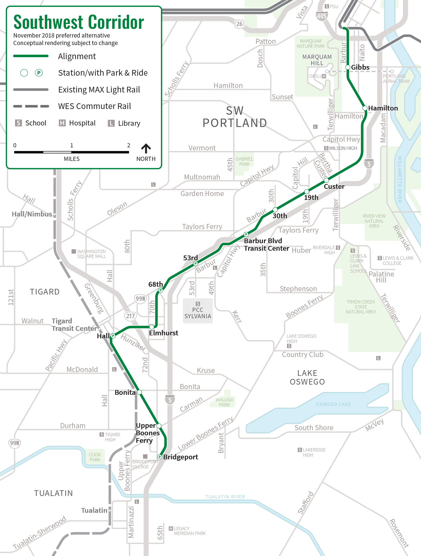
Metro adopted its 2035 RTP in June 2010 where it identified a segment of OR 99W between Portland and Sherwood as the region's next highest-priority "high-capacity transit" corridor.:2–46:1 In January 2011, The FTA granted Metro $2million to begin studying this formally named "Southwest Corridor". The funds focused on the assessment of various mode alternatives, including light rail, commuter rail, streetcar, and bus rapid transit. The Southwest Corridor Plan officially launched later on September 28, formalizing the development of a unified transportation plan between the involved communities and jurisdictions.:1 In June 2013, the project steering committee selected light rail and bus rapid transit as the alternatives for further consideration.:2 Citing a lack of present and future demand, the steering committee eliminated further planning using the alternatives to Sherwood. They also rerouted the proposed alignment in Tigard through the Tigard Triangle in response to local opposition to the removal of auto lanes from OR 99W.:3
In June 2014, the steering committee determined a refined route for further study that ran from the southern end of the Portland Transit Mall in downtown Portland to just east of Tualatin station in downtown Tualatin;:6–7 this route was later shortened to terminate at Bridgeport Village. The following year, proposals to serve Marquam Hill and Hillsdale with tunnels were dropped from the plan because they would be too costly, have severe construction impacts, and attract few new transit riders. In May 2016, the steering committee voted to select light rail as the preferred mode alternative over bus rapid transit. They also removed a tunnel to PCC Sylvania from further consideration. After passing a measure requiring voters to approve the construction of any high-capacity transit built within city limits, Tigard voters approved the light rail extension the following September.
At an estimated cost of $2.6 billion to $2.9 billion, the project was included in a regional transportation funding measure called "Get Moving 2020". In light of a budget gap of $462million, planners proposed reducing lanes on Barbur Boulevard and shortening the line's route to terminate in downtown Tigard. Both proposals were rejected in November 2019. Private negotiations, as well as Metro's approval to increase the project's requested budget by $125million in the 2020 ballot measure, reduced the budget gap to around $100million. On November 3, 2020, voters rejected the measure. Had it been approved, the extension would have begun construction in 2022 and opened by 2027. It had been expected to serve approximately 37,500 riders by 2035.
Service reductions
On April 22, 2026, the TriMet Board of Directors approved a proposal to eliminate Green Line service between PSU South station and Gateway Transit Center, retaining service only along the I-205 section, between Gateway Transit Center and Clackamas Town Center Transit Center. The plan, which is part of a larger service adjustment that includes changes to 34 bus routes, is expected to save TriMet $26million amid an ongoing budget deficit. The service change began on August 23, 2026.
Route
A Green Line train seen crossing over Foster Road in 2010
The Green Line is 6.5 miles (10.5km) long and serves the I-205 MAX Light Rail. Its northern termini is at the Gateway/Northeast 99th Avenue Transit Center situated at Northeast 99th Avenue and Northeast Pacific Street. Green Line trains must use the center track to terminate.
After Gateway Transit Center, the Green Line proceeds south, entering the I-205 MAX extension just east of I-205. Throughout most of this stretch, the line is grade-separated as part of the I-205 busway, running either above or below roadway intersections. The exception is an at-grade crossing at Southeast Flavel Street. Much of this segment also parallels the I-205 Bike Path. Between Southeast Lincoln and Grant streets, the tracks enter a tunnel beneath the freeway, exiting on the opposite side just north of Southeast Division Street. Above Johnson Creek Boulevard, it travels on a 1,400-foot-long (430m) overpass, the extension's longest elevated structure. South of Southeast Fuller Road station, the line dips under the Otty Road and Monterey Avenue overpasses before terminating at Clackamas Town Center Transit Center near Southeast Sunnyside Road.
The Green Line also formally shared the northbound segment of the Portland Transit Mall with the Yellow Line, which diverges for Expo Center station in North Portland after crossing the Steel Bridge. It shares the southbound segment with the Orange Line, which continues beyond PSU South/Southwest 5th and Jackson station for Southeast Park Avenue station near Milwaukie. The Green Line also shared a portion of the Eastside MAX with Blue and Red lines between Rose Quarter Transit Center and Gateway Transit Center.
A geographic map of the MAX Green Line (in red) relative to the rest of the network (in black) with icons marking the line's termini.
Clackamas Town Center Transit Center, the Green Line's eastern terminus
SE Powell Boulevard station
Gateway Transit Center
Service
TriMet designates the Green Line as a "Frequent Service" route, which means that service runs every 15 minutes during most of the day. Frequency is reduced to 30 minutes during early and late off-peak hours. Trains operate on weekdays from 4:16am to 1:06am the next day and on weekends from 5:42am to 1:03am. End-to-end travel from Clackamas Town Center Transit Center to Gateway Transit Center takes 19 minutes.
Ridership
The Green Line averaged 11,202 riders in May 2025, the third busiest in the MAX system. Before the start of construction, a PSU study estimated the Green Line would carry 46,500 riders by 2025. TriMet had projected an average of 25,250 riders on weekdays for the first year, but fewer people than expected actually rode the line on the first weekday service. By the following month, TriMet had recorded approximately 17,000 trips per day. The average daily ridership in June 2010 was 19,500, increasing to 24,300 by April 2012.
In September 2019, the Green Line was the third-busiest MAX service with an average weekday ridership of 19,160, 1,480 fewer riders than the previous year. The drop in ridership—experienced systemwide—is attributed to crime and lower-income riders being forced out of the inner city by rising housing prices.
Explanatory notes
↑Green Line service commenced on September 12, 2009, during the opening of the I-205 MAX segment. The Portland Mall segment, which was part of the project, opened earlier on August 30 with inaugural service from the Yellow Line.
↑The official system schematic can be viewed on the TriMet website.
↑This list of service connections excludes TriMet bus connections. For a complete list that includes all transfers, see: List of MAX Light Rail stations.
↑Kohler, Vince (May 23, 1988). "Joint efforts of business, government could spur rail line; both groups need to finance, back line along I-205, panel says". The Oregonian. p.B5.
↑Kohler, Vince (January 17, 1991). "Clackamas County seeks federal money for rail line". The Oregonian. p.C2.
↑Bodine, Harry (January 14, 1989). "Metro OKs $1.5billion transit plan". The Oregonian. p.D1.
↑Kohler, Vince; Stewart, Bill (September 10, 1989). "Light-rail proposals gain ground in Congress; senate panel approves transportation funding bill, aiding plans for new Oregon City, Vancouver lines". The Oregonian. p.C2.
12Stewart, Bill (January 12, 1993). "County light-rail project gains momentum". The Oregonian. p.B2.
↑Stewart, Bill (September 24, 1989). "Clark County light-rail plans chugging along; more than $1million will be spent on studies on both sides of the river". The Oregonian. p.C2.
↑Oliver, Gordon (March 11, 1993). "Citizens advisory committee endorses pair of light-rail routes". The Oregonian. p.B3.
↑Maves, Norm Jr. (October 27, 1994). "25-mile route encompasses hundreds of steps". The Oregonian. p.1.
↑Oliver, Gordon (November 10, 1994). "One down, more to go for reality of north–south rail line". The Oregonian. p.C10.
↑Oliver, Gordon (February 8, 1995). "Clark County turns down north–south light rail". The Oregonian. p.1.
↑Oliver, Gordon; Hunsberger, Brent (November 7, 1996). "Tri-Met still wants that rail line to Clackamas County". The Oregonian. p.D1.
↑Oliver, Gordon (November 7, 1998). "South/North Line backers find themselves at a loss after election day defeat". The Oregonian. p.B1.
↑Stewart, Bill (September 7, 2001). "Airport MAX rolls out Monday". The Oregonian. p.B1.
↑Rose, Joseph (May 8, 2001). "New MAX plan tries to the double-team approach". The Oregonian. p.D1.
↑Rose, Joseph (June 6, 2001). "Metro planners will study two south light-rail lines". The Oregonian. p.E3.
12Oppenheimer, Laura (January 27, 2003). "New MAX plans arrive for input; a revived bid to expand light rail to Milwaukie, one of five transit proposals, may fare better now that former critics are on board". The Oregonian. p.E1.
12Leeson, Fred (March 27, 2003). "TriMet board agrees to plan for southeast light-rail lines". The Oregonian. p.C2.
12Oppenheimer, Laura (February 17, 2003). "South Corridor MAX plan unveiled". The Oregonian. p.E1.
↑Briggs, Kara (July 24, 2002). "Metro considers transit options along I-205". The Oregonian. p.D2.
↑McCarthy, Dennis (February 25, 2002). "Happy Valley-area leaders mostly argue for light rail". The Oregonian. p.B2.
↑Parker, Andy (March 22, 2004). "Polls say you like light rail: What say you?". The Oregonian. p.B1.
↑Oppenheimer, Laura (April 18, 2003). "Metro gives final OK to MAX lines". The Oregonian. p.D6.
123McCarthy, Dennis (April 11, 2007). "Work on light rail will interrupt traffic". The Oregonian. p.C3.
↑Wilson, Kimberly (July 5, 2007). "News Update: TriMet will lead free bike ride to show off new I-205 bike route". The Oregonian. p.9.
↑Nehl, Steven (November 15, 2007). "Drivers must negotiate cones on Southeast Monterey Avenue between Southeast 82nd and Southeast 85th avenues. The county aims to finish $4.2 million in improvements at the site by October 2008". The Oregonian. p.12.
↑Rivera, Dylan (July 1, 2009). "Green light for the Green Line". The Oregonian.
123Rivera, Dylan (September 13, 2009). "Thousands on MAX go Green Festivities and free rides draw takers for the new downtown–Clackamas Town Center line". The Oregonian.
↑Morgan, Steve (2010). "Expansion for Portland's MAX: New routes and equipment". Passenger Train Journal. Vol.33, no.1 – First quarter 2010. White River Productions, Inc. pp.38–40.
↑Schmidt, Brad; Miner, Colin (April 9, 2009). "TriMet's cutback plan a flat tire for many riders". The Oregonian.
↑Leeson, Fred (April 26, 2009). "TriMet is braced for tumultuous year". The Oregonian.
↑Leeson, Fred (January 25, 2007). "Back to the future for bus mall bricks". The Oregonian. p.10.
↑Joe, Fredrick D. (May 10, 2008). "Tracking progress: Last rail put in place". The Oregonian. p.B1.
↑Mortenson, Eric (May 31, 2008). "Buses get boot from bridge for rail work". The Oregonian. p.B1.
↑Beaven, Stephen (July 28, 2008). "Street work ends early on Fifth, Sixth downtown". The Oregonian. p.B1.
↑Rose, Joseph (January 25, 2009). "TriMet to test transit mall MAX tracks Starting Monday, drivers and cyclists will want to stop driving on the light-rail tracks in the new downtown Portland transit mall. That's when crews begin testing the tracks by using a big truck". The Oregonian. p.B2.


 Clackamas Town Center Transit Center, the Green Line's eastern terminus
 SE Powell Boulevard station
 Gateway Transit Center