Hurricane Lowell was a long-lived and very powerful tropical cyclone that impacted the western Hawaiian Islands, making a direct hit on Ni'ihau and Kauaʻi. Lowell was the first hurricane to directly hit the island of Kauaʻi since Hurricane Iniki in 1992. The fourteenth named storm, fifth hurricane, fourth major hurricane, and second Category 5 hurricane of the 2026 Pacific hurricane season, Lowell formed on August 27 and reached Category5 intensity on September 2. In doing so, it became the first Category 5 hurricane in the Central Pacific basin since Hurricane Walaka in 2018. Increasing wind shear and eyewall replacement cycles caused it to weaken to Category3 status by September4, but the following day, it rapidly intensified to Category 5 intensity once again. Increasing wind shear caused it to weaken to a Category2 hurricane by the time it made its direct hit on Kaua'i County, and Lowell became post-tropical by September11.
Lowell's powerful winds damaged structures and knocked out power for most Kaua'i County customers. Overall, the storm caused at least $400 million of damage in Hawai'i and killed at least three.
Meteorological history
Map plotting the storm's track and intensity, according to the Saffir–Simpson scale
On August24, the National Hurricane Center (NHC) first noted a low potential for eventual tropical cyclogenesis, related to a trough located east-southeast of Hawaii. The weather system produced thunderstorms as it drifted northeastward across the eastern Pacific Ocean. By August25, the NHC assessed a high likelihood– 70%– for a tropical cyclone to form. That day, a weak and small low-pressure area developed within the system. On August26, the low became more organized due to favorable environmental conditions. Late on August27, the NHC classified the system as Tropical Storm Lowell about 1,530miles (2,460km) east-southeast of Hawaii. The storm had a closed circulation, producing winds of 40mph (65km/h) alongside well-organized bands of convection.
Upon its formation, Lowell was moving to the east-northeast over an area of warm ocean temperatures. The storm gradually strengthened amid some northeasterly wind shear. Lowell's circulation became exposed from the thunderstorms, and the storm became disorganized. Late on August28, Lowell turned to the west, steered by a ridge to its north. Around that time, the NHC noted uncertainty in the storm's future, due to potential interaction with Tropical Storm Karina to its east. On August29, thunderstorms reformed over the circulation, although it continued to be affected by wind shear through the next day. On August31, the convection became better organized after the wind shear decreased. By that time, the NHC anticipated that Lowell would undergo rapid intensification. On September1, Lowell attained hurricane status about 575 miles (925km) to the southeast of Hilo, Hawaii.
Lowell at its initial peak intensity south-southeast of the Hawaiian Islands on September 2
Late on September1, Lowell intensified into a major hurricane, or a Category3 on the Saffir-Simpson scale. The hurricane had an eye surrounded by a ring of deep convection. Late on September2, Lowell strengthened further into a Category5 hurricane, with maximum sustained winds of 160mph (260km/h) and a minimum pressure of 927mbar (27.4inHg). Around that time, it was located about 445mi (715km) south of Hilo. Lowell became the first Category5 hurricane in the Central Pacific since Hurricane Walaka in 2018. After reaching peak intensity, Lowell weakened due to a combination of increased wind shear, dry air, and an eyewall replacement cycle. On September4, it briefly fell to Category3 intensity due to another replacement cycle. Later that day, the Hurricane Hunters observed that Lowell re-intensified into a high-end Category4 hurricane as the eyewall replacement cycle was complete. Hurricane Hunters then observed that Lowell regained Category 5 intensity a few hours later, with maximum sustained winds of 160mph (260km/h) and a minimum central pressure of 922mbar (27.2inHg). This made it the first Pacific hurricane to attain Category5 intensity more than once since Hurricane Ioke in 2006 and only one of four Pacific hurricanes to do so on record, along with Hurricane Emilia in 1994, Ioke, and Hurricane Polo a few weeks later.
Soon after attaining Category5 status a second time, Lowell again weakened slightly as its eye become less defined, possibly due to wind shear and dry air. The hurricane slowed on September5 after the ridge to its north began weakening. This was partly due to an upper-level low, located north of Hawaii and moving to the southwest; the low caused Lowell to turn sharply northward. As wind shear increased and sea surface temperatures decreased, Lowell weakened below major hurricane strength on September7. Around 09:00UTC on September8, the center of Lowell passed about 40mi (64km) west of Niʻihau. High wind shear caused the hurricane to weaken quickly, as the center became exposed from the convection. On September9, Lowell dropped to tropical storm status. It turned back to the west due to a building ridge, where dry air continued to affect the storm. On September11, the NHC redesignated Lowell as a post-tropical cyclone, more than 24hours since the storm produced thunderstorms near the center.
Scientists from Climate Central concluded that anthropogenic climate change has made the unusually warm sea surface temperatures along Lowell’s path up to 60 times more likely. As the hurricane intensified, it moved over waters that were 0.7°C to 1.1°C (1°F to 2°F) warmer than normal, which human-caused climate change made 10-20 times more probable.
Preparations
On September6 (UTC), the NHC issued a hurricane watch for the eastern part of Papahānaumokuākea Marine National Monument and a tropical storm watch for Kauai County. Līhuʻe Airport was shut down in preparation of the hurricane. Later that day, the agency upgraded the watches to warnings. A flood watch was also in effect for the main Hawaiian Islands through September8, with heavy rainfall expected to cause flash flooding and mudslides, especially on Kauaʻi and parts of the Big Island. Due to further eastward shifts in the forecast path of the storm, a hurricane watch was issued for Kauai County on September 7, 2026 (UTC) and further upgraded to a hurricane warning later that day. A few hours later, still more eastward shifts in the track forecast prompted a tropical storm watch, then a tropical storm warning, for Oahu. Early on September 8 (UTC), a tornado watch was issued for Kauai County and adjacent waters, the first tornado watch issued for the state of Hawaii on record.
On September3, Hawaii governor Josh Green issued a state of emergency due to the threat from Lowell and potentially Karina. The state activated 129Hawaii National Guard members while also sending six high-water vehicles to Kauai. Two state parks were closed to campers due to the hurricane. Campers were notified to vacate the parks immediately on September 4.
Many Ni'hau residents had traveled to Kauaʻi for a funeral ahead of Lowell's close pass by the island, and were unable make proper preparations.
Impact
Rocks are seen pushed onto residential properties in Kekaha, Hawaii, after Hurricane Lowell's surf and storm surge impacts.
Prior to the brunt of impacts from Lowell, Kauaʻi's only weather radar was knocked out. The hurricane dropped heavy rainfall across Hawaii, peaking at 21.11in (536mm) in Kilohana on Kauaʻi. Wind gusts in the state peaked at 92mph (148km/h) at Puʻu Lua. Sustained winds to 59mph (95km/h) and a gust of 84mph (135km/h) were recorded at the Līhuʻe Airport. Powerful waves and storm surge moved into coastal areas such as Kekaha and Poʻipu, causing extensive damage to structures and roadways. In Kekaha, Kaumualiʻi Highway fronting Kekaha Beach was completely obstructed by rocks and road fragments. Kauaʻi Island Utility Cooperative reported that strong winds from Lowell knocked out power to over 91% of Kaua'i County. Power outages at the Waimea Wastewater Treatment Plant led to the spill of 20,000 gallons of wastewater.
A house in Waimea, Kauai, Hawaii, is seen with damage from Hurricane Lowell's powerful winds.
Near Baby Beach in Poʻipū, a home was swept off of its foundation and onto neighboring properties. In Poʻipū, storm surge paired with high surf damaged parts of the Beach House Restaurant and the Sheraton Kauaʻi Resort, which were among those hit the hardest. A house in Hanapēpē lost its roof as a result of strong winds. Port Allen Boat Harbor was extensively damaged. Storm surge and surf also contributed to the destruction of Waimea Pier. Further west in Kekaha, multiple homes were damaged by hurricane-force winds and storm surge. In the commercial area of Līhuʻe, Hokulei Village and Kukui Grove sustained minor damages to their properties. Storm surge caused multiple shipping containers to be taken from Kaumālapa‘u Harbor, Lānaʻi's only commercial harbor, into the ocean. Bollards protecting the edge of the harbor were moved out of place or destroyed, damaging the harbor's protective seawall and causing multiple sinkholes to form.
A 74-year-old man in Kaua‘i was killed by the storm surge related to Lowell. A 59-year-old man was found dead in Wainiha. On Oʻahu, a tree fell on a homeless man's tent, killing him inside. Oahu recorded 21,000 power outages.
On September 18, it was reported that 18 homes in Kaua’i had been destroyed, with at least a 100 sustaining major damage. More than 700 additional homes were damaged in the county.
Aftermath
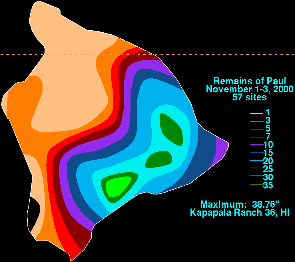
Wettest tropical cyclones and their remnants in Hawaii Highest-known totals
On September 7, the Hawaiʻi State Department of Education cancelled school for Kauaʻi and Oʻahu in advance of the storm's approach. Due to the damage left on Kauaʻi, the department extended the closure of schools on the island until September 11.
On September 8, the Līhuʻe Airport was reopened to travelers. HDOT advised that travelers should expect delays and allow extra time to check in and get through TSA. The following day, Hawaiian and Alaska Airlines issued a notice that 'longer than usual' lines at the airport were occurring. The island's two major shopping centers, Kukui Grove and The Shops at Kukui'ula were closed due to power loss.
Ni'hau residents were reported safe by island management, and there was a supply of food and water available for residents.
In response to cleanup efforts by residents, the County of Kauaʻi reopened the Kekaha Landfill and transfer stations across the island. Collection fees were waived temporarily. A wastewater spill was reported at the Waimea Wastewater Treatment Plant. In response to food and ice shortages caused by prolonged power outages, food distribution sites were set up in key points across the island. Local businesses such as Meme's Farmstand and The Musubi Truck offered free food to the community.
On September 9, Governor Josh Green reported that initial damage estimates indicate the storm will cost more than US$400million, exceeding the damage from Hurricane Lala, which struck Hawaii a few weeks prior. Governor Green also stated that early in the recovery process, Lowell seemed to have caused more damage than Hurricane Iniki in 1992, the costliest tropical cyclone to hit the State of Hawaiʻi to date, with early estimates placing the total damage cost between $500 million and $1 billion. By September 23, Governor Green stated that the state had spent $112.4 million on post-Lowell recovery estimates, and over $1 billion on natural disaster recovery statewide throughout the year.
↑The National Hurricane Center officially defines a direct hit as, for locations on the right-hand side of the track, when the cyclone passes within a distance equal to twice the radius of maximum wind.
Reinhart (August 24, 2026). "Tropical Weather Outlook"(TXT). National Hurricane Center. Archived from the original on September 7, 2026. Retrieved September 3, 2026.
Hagen (August 24, 2026). "Tropical Weather Outlook"(TXT). National Hurricane Center. Retrieved September 3, 2026.
↑Blake (August 25, 2026). "Tropical Weather Outlook"(TXT). National Hurricane Center. Archived from the original on September 6, 2026. Retrieved September 3, 2026.
↑Cangialosi, John; Katz, Jeremy; Evans, Lori (August 25, 2026). "Tropical Weather Outlook"(TXT). National Hurricane Center. Archived from the original on September 6, 2026. Retrieved September 3, 2026.
↑Evans; Zelinsky (August 26, 2026). "Tropical Weather Outlook"(TXT). National Hurricane Center. Archived from the original on September 6, 2026. Retrieved September 3, 2026.
↑US Department of Commerce, NOAA. "Radar Free Text Messages for Hawaii". www.weather.gov. NOAA's National Weather Service. Archived from the original on 2026-08-13. Retrieved 2026-09-08.
↑Central Pacific Hurricane Center. Tropical Cyclones During the Years 1900-1952 (Report). United States National Oceanic and Atmospheric Administration's National Weather Service. Archived from the original on April 19, 2019. Retrieved January 26, 2007.
↑Roth, David M.; Hydrometeorological Prediction Center. "Remains of Paul". Tropical Cyclone Point Maxima(GIF). United States National Oceanic and Atmospheric Administration's National Weather Service. Archived from the original on April 19, 2019. Retrieved December 28, 2007.
↑Central Pacific Hurricane Center. The 1970 Central Pacific Tropical Cyclone Season(PDF) (Report). United States National Oceanic and Atmospheric Administration's National Weather Service. Retrieved December 28, 2007.
↑"Lowell PNS". National Weather Service. Retrieved September 10, 2026.
↑Central Pacific Hurricane Center. The 1957 Central Pacific Tropical Cyclone Season(PDF) (Report). United States National Oceanic and Atmospheric Administration's National Weather Service. Retrieved November 28, 2007.